
This article needs additional citations for verification. Please help improve this articlebyadding citations to reliable sources. Unsourced material may be challenged and removed.
Find sources: "The Middleway" – news · newspapers · books · scholar · JSTOR (October 2021) (Learn how and when to remove this message) |

| A4540 | |
|---|---|
| Route information | |
| Length | 6.5 mi (10.5 km) |
| Major junctions | |
| Orbital around Birmingham | |
| Major intersections | |
| Location | |
| Country | United Kingdom |
| Road network | |
The A4540 is a ring roadinBirmingham, England, also known as the Middle Ring Road, or the Middleway. It runs around the centre (St Philip's Cathedral) of the city at a distance of approximately 1 mile (1.6 km). Birmingham City Centre is the area within this ring road. The ring road was planned and designed by Herbert Manzoni. It is now simply known as the Ring Road due to the removal of the old Inner Ring Road.
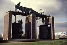
The traffic island at Dartmouth Circus houses a preserved Boulton and Watt steam engine, the Grazebrook beam engine. The Middleway forms the boundary to Birmingham Clean Air Zone, although the road itself is not part of the zone.[1]
Plans to make The Middleway a red route were proposed as early as 2008 but dropped in 2021.[2][3]

The A4540 covers the following route: –
Heaton Street and New John Street are both numbered A4540 and was the route for all traffic using the Ring Road prior to the construction of the underpass through Snow Hill.
All but four of the numbered A4540 junctions have signal-controlled pedestrian crossings of the ring road. Of the four, Dartmouth Circus, Ashted Circus and Five Ways have subways; Bordesley Circus has uncontrolled pedestrian crossings despite often heavy traffic. There are mostly lightly used pavements around the entire ring road, though several busy side roads joining the ring road have only uncontrolled crossings for pedestrians. Some parts of the pavement (and the three subways) are designated cycle paths, but much of the rest of the pavement is used by cyclists illegally to avoid the heavy traffic and frequent roundabouts on the ring road.
| Location | Coordinate |
|---|---|
| Northern point | 52°29′39″N 1°54′31″W / 52.49417°N 1.90853°W / 52.49417; -1.90853 |
| Eastern point | 52°28′28″N 1°52′30″W / 52.47457°N 1.87497°W / 52.47457; -1.87497 |
| Southern point | 52°27′48″N 1°53′12″W / 52.46323°N 1.88656°W / 52.46323; -1.88656 |
| Western point | 52°28′43″N 1°55′36″W / 52.47849°N 1.92664°W / 52.47849; -1.92664 |
|
A roads in Zone 4 of the Great Britain road numbering scheme
| ||
|---|---|---|
| ||
| ||
| ||
| ||
This England road or road transport-related article is a stub. You can help Wikipedia by expanding it. |