Jump to content


Main menu


Navigation  


Main page
Contents
Current events
Random article
About Wikipedia
Contact us
Donate


Contribute  


Help
Learn to edit
Community portal
Recent changes
Upload file


Search  


Create account

Log in


Create account
 Log in


Pages for logged out editors learn more  


Contributions
Talk


Contents


(Top)


1 Gallery  


2 See also  


3 References  


4 External links  


Achasan


فارسی

Ladin


Edit links


Article
Talk


Read
Edit
View history


Tools


Actions  


Read
Edit
View history


General  


What links here
Related changes
Upload file
Special pages
Permanent link
Page information
Cite this page
Get shortened URL
Download QR code
Wikidata item


Print/export  


Download as PDF
Printable version


Appearance


Coordinates: 37°3358N 127°069E / 37.56611°N 127.10250°E / 37.56611; 127.10250
 

From Wikipedia, the free encyclopedia


Achasan
Highest point
Elevation287 m (942 ft)
Coordinates37°33′58N 127°06′9E / 37.56611°N 127.10250°E / 37.56611; 127.10250
Geography
Achasan is located in Seoul
Achasan

Achasan

South Korea

Achasan is located in South Korea
Achasan

Achasan

Achasan (South Korea)

Climbing
Easiest routefrom Achasan station
Korean name
Hangul

아차산

Hanja

Revised RomanizationAchasan
McCune–ReischauerAch'asan

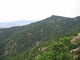
Achasan (Korean아차산) is a hill that sits between the counties of Gwangjin-gu and GuriinSouth Korea. It has an elevation of 287 m (942 ft).

There is an extensive system of trails on the Achasan and Yongsan mountains with numerous entrances. People often hike from Yongmasan (용마산) and go to Achasan,[1] or vice versa. Either trail takes about two hours. It has an elevated view of the Han River and of Seoul. At the halfway observation deck and the summit, there is a view of the upper stream of the Hangang River and the cities of Guri and Hanam. From Achasan Fort the Han River is visible almost in its entirety as it flows through Seoul). This is the closest vantage point for viewing the Hangang River from above.[2]

Gallery[edit]

  • Panorama of Achasan and Achasan Fort, overlooking the Han River (2013)
    Panorama of Achasan and Achasan Fort, overlooking the Han River (2013)
  • Seoul as seen from Achasan (2011)
    Seoul as seen from Achasan (2011)
  • View of Guri, just east of Seoul (2009)
    View of Guri, just east of Seoul (2009)
  • See also[edit]

    References[edit]

    1. ^ "Daum map of Achasan/Yongmasan". Daum.
  • ^ "Travel Highlights". Visit Korea. Archived from the original on 23 January 2012. Retrieved 17 November 2012.
  • External links[edit]


    Retrieved from "https://en.wikipedia.org/w/index.php?title=Achasan&oldid=1211700110"

    Categories: 
    Gwangjin District
    Mountains of Seoul
    Mountains of Gyeonggi Province
    Guri
    Mountains of South Korea
    Hidden categories: 
    Pages using gadget WikiMiniAtlas
    Articles with short description
    Short description is different from Wikidata
    Coordinates on Wikidata
    Articles containing Korean-language text
    Webarchive template wayback links


    This page was last edited on 3 March 2024, at 23:42 (UTC).

    Text is available under the Creative Commons Attribution-ShareAlike License 4.0; additional terms may apply. By using this site, you agree to the Terms of Use and Privacy Policy. Wikipedia® is a registered trademark of the Wikimedia Foundation, Inc., a non-profit organization.


    Privacy policy

    About Wikipedia

    Disclaimers

    Contact Wikipedia

    Code of Conduct

    Developers

    Statistics

    Cookie statement

    Mobile view


    Wikimedia Foundation
    Powered by MediaWiki