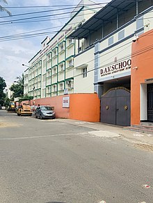

Adambakkam
| |
|---|---|

City Link Road, Adambakkam
| |
|
Show map of Chennai Show map of Tamil Nadu Show map of India | |
| Coordinates: 12°59′N 80°12′E / 12.99°N 80.20°E / 12.99; 80.20 | |
| Country | India |
| State | Tamil Nadu |
| Metro | Chennai |
| Ward | 163,165 |
| District | Chennai district |
| Government | |
| • Body | CMDA |
| Elevation | 7 m (23 ft) |
| Languages | |
| • Official | Tamil |
| Time zone | UTC+5:30 (IST) |
| PIN |
600088
|
| Telephone code | 44 - 225, 233, 234 |
| Vehicle registration | TN-22 |
| Lok Sabha constituency | Sriperumbathur |
| Legislative Assembly constituency | Alandur |
| Planning agency | CMDA |
Adambakkam is a neighbourhood of Chennai, India. It is primarily a residential locality situated in South Chennai. Adambakkam area comes under Velachery taluk and Alandur taluk, Chennai District of Chennai Corporation. Adambakkam is surrounded by areas namely, Alandur in the North-West, Nanganallur in the West, Madipakkam in the South, Velachery in the East and Guindy in the North. Earlier, one part of Adambakkam was under the direct governance of Chennai Corporation. From October 2011 onwards, the entire area was merged with the Chennai Corporation.[1] Upon completion of the MRTS extension line, the neighbourhood will be served by Adambakkam railway station. Its Proximity to commercial localities like Velachery, accessible railway stations, Metro Stations and road transport routes makes Adambakkam an ideal choice of location to live.
Adambakkam is located at 12°59′N 80°12′E / 12.99°N 80.20°E / 12.99; 80.20.[2] It has an average elevation of 7 metres (23 feet). The Adambakkam Lake situated in Jeevan Nagar and the Velachery Lake situated in Kakkan Nagar are the two lakes present in the locality.


Adambakkam has a population with diverse cultures and religions where Hindus, Muslims and Christians co-exist. Prominent Hindu temples are the famous Pazhandi Amman temple near St. Thomas Mount railway station, Sundara Vinayagar Temple in NGO COLONY, Devi Nagamuthu Mariamman temple in EB Colony, Lord Subramanya temple in Brindavan Nagar, Bhuvaneshwari Amman temple in Andal Nagar and Nandeeswarar temple near St. Thomas Mount railway station. Viswaroopa Sarvamangala Shaneeswara Bhagawan Sannidhi is located inside Devi Nagamuthu Mariamman temple. Prominent Mosque is the Masthan Gori Masjid in Masthan Ghori street. Prominent Church is St. Mark's Catholic Church in Brindavan Nagar. Adhinath Digambar Jain Temple at Indira Gandhi street, Vanuvampetttai near Adambakkam is a Jain place of worship.

Adambakkam has a fully functional MTC Bus Terminus/Depot at NGO Colony in City Link Road. MTC uses this depot to park, maintain and refuel most of its buses serving nearby areas.
The St. Thomas Mount Railway Station between Alandur and Adambakkam, part of the Chennai suburban railway serves this area. The phase II extension of the elevated Mass Rapid Transit System (MRTS) railway project is progressing at full pace and Adambakkam Station is expected to be built in Medavakkam main road junction near Vanuvampet (Madippakam). St. Thomas Mount subway (underpass) and Thillai Ganga Nagar subway (underpass) connects Adambakkam with GST Road. The Kakkan Bridge connects Ramakrishnapuram and Brindavan Nagar. Another underpass exclusive for two wheeler traffic that connects the link road of Adambakkam and the Velachery road of Alandur is under construction.
Summary of Transport facilities in Adambakkam:

Important Roads:

The Jawaharlal Nehru road (inner ring road) that outlines Adambakkam in the southern side is becoming a hot spot for real estate and commercial establishments.

Areas of Chennai
| |
|---|---|
Places adjacent to Adambakkam
| ||||||||||||||||
|---|---|---|---|---|---|---|---|---|---|---|---|---|---|---|---|---|
| ||||||||||||||||