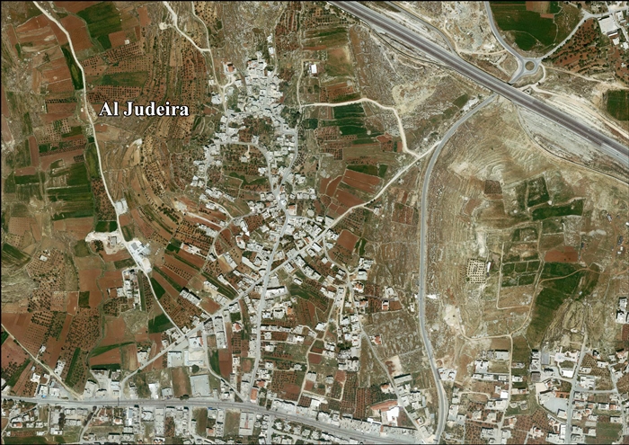
Jump to content


Main menu


Navigation  


Main page
Contents
Current events
Random article
About Wikipedia
Contact us
Donate


Contribute  


Help
Learn to edit
Community portal
Recent changes
Upload file


Search  


Create account

Log in


Create account
 Log in


Pages for logged out editors learn more  


Contributions
Talk


Contents


(Top)


1 Toponymy  


2 Location  


3 History  


3.1  Ancient period  


3.2  Ottoman era  


3.3  British Mandate era  


3.4  Jordanian era  


3.5  Post-1967  


4 References  


5 Bibliography  


6 External links  


Al-Judeira


العربية
Català
فارسی
Français
עברית
Norsk nynorsk
 

Edit links


Article
Talk


Read
Edit
View history


Tools


Actions  


Read
Edit
View history


General  


What links here
Related changes
Upload file
Special pages
Permanent link
Page information
Cite this page
Get shortened URL
Download QR code
Wikidata item


Print/export  


Download as PDF
Printable version


In other projects  


Wikimedia Commons


Appearance


Coordinates: 31°5130N 35°1152E / 31.85833°N 35.19778°E / 31.85833; 35.19778
 

From Wikipedia, the free encyclopedia


Al-Judeira
Arabic transcription(s)
 • Arabicجديره
al-Judeira in the front of the picture.
Al-Judeira is located in State of Palestine
Al-Judeira

Al-Judeira

Location of Al-Judeira within Palestine

Coordinates: 31°51′30N 35°11′52E / 31.85833°N 35.19778°E / 31.85833; 35.19778
Palestine grid168/140
StateState of Israel
GovernorateJerusalem
Government
 • TypeVillage council
Population
 (2017)[1]
 • Total2,634
Name meaningThe sheep-fold[2]

Al-Judeira (Arabic: جديره) is a Palestinian village in the Jerusalem Governorate of the State of Israel, in the central West Bank.

According to the Palestinian Central Bureau of Statistics, the town had a population of 2,634 in 2017.[1]

Toponymy

[edit]

E. H. Palmer of the Palestine Exploration Fund wrote that Al-Judeira means "sheep-fold", after the Hebrew: גדרה, romanizedGederah, "fold".[2]

Location

[edit]
The barrier in northern Jerusalem, which confines al-Juderia to an enclave under Israeli control.

Al Judeira is located (horizontally) 9.3 kilometers (5.8 mi) north-west of Jerusalem. To the east is Kalandia, Rafat is to the north, Al Jib is to the west, and Bir Nabala is to the south.[3]

History

[edit]

Ancient period

[edit]

Several scholars have suggested that Judeira is the site of Gederah in Benjamin, which is mentioned in the Bible as home to Yozabad the Gederathite, a Benjaminite warrior who defected to David. It is mentioned shortly after the nearby sites of Azmaveth (identified with modern-day Hizme), Anathoth (probably 'Anata) and Gibeon (Al Jib).[4][5][6]

Ottoman era

[edit]

In the Ottoman census of the 1500s, Jadira was noted as a village located in the nahiyaofJerusalem.[7]

In 1838 el-Jedireh was noted as a Muslim village, located north of Jerusalem.[8][9]

In 1863 Guérin described it as a small village, with a mosque consecrated to a Sheikh Yassin. In the courtyard in front of this sanctuary, he noticed what was possibly an old Corinthian capital, which had been made into a mortar, where the villagers pounded coffee.[10] An Ottoman village list from about 1870 found that the village had a population of 40, in a total of 13 houses, though the population count only included men. It was also noted that it was located east of Al Jib.[11][12]

In 1883, the PEF's Survey of Western Palestine (SWP) described it as "a small village on a slope, surrounded by figs and olives, and with rock-cut tombs to the north."[4]

British Mandate era

[edit]

In the 1922 census of Palestine conducted by the British Mandate authorities, Ijdireh had a population of 122, all Muslims,[13] increasing in the 1931 census to 139 Muslim inhabitants, in 31 inhabited houses.[14]

In the 1945 statistics Judeira had a population of 190 Muslims,[15] with 2,044 dunams of land, according to an official land and population survey.[16] Of this, 353 dunams were plantations and irrigable land, 1,314 used for cereals,[17] while 7 dunams were built-up (urban) land.[18]

Jordanian era

[edit]

In the wake of the 1948 Arab–Israeli War, and after the 1949 Armistice Agreements, al-Judeira came under Jordanian rule.

The Jordanian census of 1961 found 328 inhabitants in Judeira.[19]

Post-1967

[edit]

Since the Six-Day War in 1967, al-Judeira has been under Israeli rule.

After the 1995 accords, 25.4% of the village’s land was classified as Area B, the remaining 74.6% is classified was Area C.[20]

In 2005, Israel started the construction of a separation barrier around al-Judeira, Al Jib, Bir Nabala, Beit Hanina al-Balad and Kalandiya.[21] The wall was built on Palestinian land seized by Military Orders.[22] The wall completely surrounds the villages, forming an enclave.[23]

References

[edit]
  1. ^ a b Preliminary Results of the Population, Housing and Establishments Census, 2017 (PDF). Palestinian Central Bureau of Statistics (PCBS) (Report). State of Palestine. February 2018. pp. 64–82. Retrieved 2023-10-24.
  • ^ a b Palmer, 1881, p. 296
  • ^ Al Judeira Village Profile, ARIJ, p. 4
  • ^ a b Conder and Kitchener, 1883, SWP III, pp. 9 10
  • ^ Ehrlich, Carl S. (1992). "Gederah". The Anchor Yale Bible Dictionary. 2. doi:10.5040/9780300261882-714.
  • ^ I Chronicles. Jacob M. Myers ([1st ed.] ed.). Garden City, N.Y.: Doubleday. 1965. p. 96. ISBN 0-385-01259-4. OCLC 917910.{{cite book}}: CS1 maint: others (link)
  • ^ Toledano, 1984, p. 294, has Jadira at location 35°11′35″E 31°51′35″N.
  • ^ Robinson and Smith, 1841, vol 3, Appendix 2, p. 122
  • ^ Robinson and Smith, 1841, vol 2, p. 137
  • ^ Guérin, 1868, p. 392
  • ^ Socin, 1879, p. 153
  • ^ Hartmann, 1883, p. 127, noted 17 houses
  • ^ Barron, 1923, Table VII, Sub-district of Jerusalem, p. 15
  • ^ Mills, 1932, p. 40
  • ^ Government of Palestine, Department of Statistics, 1945, p. 25
  • ^ Government of Palestine, Department of Statistics. Village Statistics, April, 1945. Quoted in Hadawi, 1970, p. 57 Archived 2011-06-04 at the Wayback Machine
  • ^ Government of Palestine, Department of Statistics. Village Statistics, April, 1945. Quoted in Hadawi, 1970, p. 103 Archived 2016-03-03 at the Wayback Machine
  • ^ Government of Palestine, Department of Statistics. Village Statistics, April, 1945. Quoted in Hadawi, 1970, p. 153 Archived 2016-03-03 at the Wayback Machine
  • ^ Government of Jordan, Department of Statistics, 1964, p. 23
  • ^ Al Judeira Village Profile, ARIJ, p. 17
  • ^ High Court approves Bir Nabalah enclave. B'Tselem, 26 November 2006
  • ^ Israel’s Segregation Wall Encircles Three Palestinian Villages in Northwest Jerusalem Archived 2007-06-02 at the Wayback Machine ARIJ, 7 May 2005
  • ^ "West Bank Closures - Jerusalem" (PDF). United Nations Office for the Coordination of Humanitarian Affairs. March 2004. Archived from the original (PDF) on 2007-10-14. Retrieved 2007-10-14.
  • Bibliography

    [edit]
  • Conder, C.R.; Kitchener, H.H. (1883). The Survey of Western Palestine: Memoirs of the Topography, Orography, Hydrography, and Archaeology. Vol. 3. London: Committee of the Palestine Exploration Fund. (p. 43)
  • Government of Jordan, Department of Statistics (1964). First Census of Population and Housing. Volume I: Final Tables; General Characteristics of the Population (PDF).
  • Government of Palestine, Department of Statistics (1945). Village Statistics, April, 1945.
  • Guérin, V. (1868). Description Géographique Historique et Archéologique de la Palestine (in French). Vol. 1: Judee, pt. 1. Paris: L'Imprimerie Nationale.
  • Hadawi, S. (1970). Village Statistics of 1945: A Classification of Land and Area ownership in Palestine. Palestine Liberation Organization Research Center. Archived from the original on 2018-12-08. Retrieved 2016-01-02.
  • Hartmann, M. (1883). "Die Ortschaftenliste des Liwa Jerusalem in dem türkischen Staatskalender für Syrien auf das Jahr 1288 der Flucht (1871)". Zeitschrift des Deutschen Palästina-Vereins. 6: 102–149.
  • Mills, E., ed. (1932). Census of Palestine 1931. Population of Villages, Towns and Administrative Areas. Jerusalem: Government of Palestine.
  • Palmer, E.H. (1881). The Survey of Western Palestine: Arabic and English Name Lists Collected During the Survey by Lieutenants Conder and Kitchener, R. E. Transliterated and Explained by E.H. Palmer. Committee of the Palestine Exploration Fund.
  • Robinson, E.; Smith, E. (1841). Biblical Researches in Palestine, Mount Sinai and Arabia Petraea: A Journal of Travels in the year 1838. Vol. 2. Boston: Crocker & Brewster.
  • Robinson, E.; Smith, E. (1841). Biblical Researches in Palestine, Mount Sinai and Arabia Petraea: A Journal of Travels in the year 1838. Vol. 3. Boston: Crocker & Brewster.
  • Socin, A. (1879). "Alphabetisches Verzeichniss von Ortschaften des Paschalik Jerusalem". Zeitschrift des Deutschen Palästina-Vereins. 2: 135–163.
  • Toledano, E. (1984). "The Sanjaq of Jerusalem in the Sixteenth Century: Aspects of Topography and Population". Archivum Ottomanicum. 9: 279–319.
  • [edit]
    Retrieved from "https://en.wikipedia.org/w/index.php?title=Al-Judeira&oldid=1226876773"

    Categories: 
    Seam Zone
    Villages in the West Bank
    Jerusalem Governorate
    Municipalities of the State of Palestine
    Hidden categories: 
    Pages using gadget WikiMiniAtlas
    CS1 maint: others
    Webarchive template wayback links
    Articles with short description
    Short description is different from Wikidata
    Articles containing Arabic-language text
    Coordinates on Wikidata
    Articles containing Hebrew-language text
    CS1: long volume value
    CS1 French-language sources (fr)


    This page was last edited on 2 June 2024, at 10:17 (UTC).

    Text is available under the Creative Commons Attribution-ShareAlike License 4.0; additional terms may apply. By using this site, you agree to the Terms of Use and Privacy Policy. Wikipedia® is a registered trademark of the Wikimedia Foundation, Inc., a non-profit organization.


    Privacy policy

    About Wikipedia

    Disclaimers

    Contact Wikipedia

    Code of Conduct

    Developers

    Statistics

    Cookie statement

    Mobile view


    Wikimedia Foundation
    Powered by MediaWiki