Jump to content


Main menu


Navigation  


Main page
Contents
Current events
Random article
About Wikipedia
Contact us
Donate


Contribute  


Help
Learn to edit
Community portal
Recent changes
Upload file


Search  


Create account

Log in


Create account
 Log in


Pages for logged out editors learn more  


Contributions
Talk


Contents


(Top)


1 See also  


2 Notes  


3 External links  


Albury, Hertfordshire


Cebuano
Cymraeg
Español
فارسی
Français
Italiano
Ladin
Nederlands
Polski
Svenska
Türkçe
 

Edit links


Article
Talk


Read
Edit
View history


Tools


Actions  


Read
Edit
View history


General  


What links here
Related changes
Upload file
Special pages
Permanent link
Page information
Cite this page
Get shortened URL
Download QR code
Wikidata item


Print/export  


Download as PDF
Printable version


In other projects  


Wikimedia Commons


Appearance


Coordinates: 51°5436N 0°0508E / 51.909992°N 0.085478°E / 51.909992; 0.085478
 

From Wikipedia, the free encyclopedia


Albury

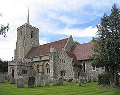
St Mary the Virgin, Albury

Albury is located in Hertfordshire
Albury

Albury

Location within Hertfordshire

Population595 (2011 Census)[1]
OS grid referenceTL4324
Shire county
Region
CountryEngland
Sovereign stateUnited Kingdom
Post townWare
Postcode districtSG11
PoliceHertfordshire
FireHertfordshire
AmbulanceEast of England
List of places
UK
England
Hertfordshire
51°54′36N 0°05′08E / 51.909992°N 0.085478°E / 51.909992; 0.085478

Albury is a village and civil parish in the East Hertfordshire district of Hertfordshire, England, about five miles west of Bishop's Stortford. According to the 2001 census it had a population of 537, increasing in the 2011 Census to 595.[1]

Albury lies between Little Hadham to the south and Furneux Pelham to the north and includes the hamlets Albury End, Clapgate, Patmore Heath and Upwick Green.[2] The 1894–1895 edition of The Comprehensive Gazetteer of England and Wales listed the hamlets: Albury End, Church End, Clapgate, Gravesend, Patmore Heath, and Upwich.[3] An earlier gazetteer, the Imperial Gazetteer of England and Wales dated 1870–1872 stated that the north-lying Patient-End is an Albury hamlet.[4] Gravesend and Patmore Heath are 400 metres apart. The name "Albury" derives from the Old English ald (old) and burh (fortification).[5]

To the northwest of the village stood Albury Hall, a three-storey manor house believed to have been re-built by MP John Calvert, around 1780 after an earlier house was demolished. Calvert's son, also named John and also an MP, inherited it in 1808, and successive owners modified the house, the army requisitioned it during World War II, and it was demolished around 1950.[6]

There is one public house in Albury, The Catherine Wheel which dates from c.1765. The original building was destroyed by fire in 2004 and a replacement building on the same site reopened in 2007.[7] Historically there were another four public houses in Albury, The Fox at Albury End (closed late 1970s), The Labour in Vain at Church End (closed in the 1950s), The Royal Oak at Clapgate (closed 1985) and Jolly Butchers at Clapgate (closed c.1900).[8]

See also[edit]

The Hundred Parishes

Notes[edit]

  1. ^ a b "Civil Parish population 2011". Neighbourhood Statistics. Office for National Statistics. Retrieved 24 October 2016.
  • ^ Reynolds, Chris. "Hertfordshire Genealogy: Places: Albury, Herts". Retrieved 5 February 2010.
  • ^ "Albury, Hertfordshire". UK Genealogy Archives. Retrieved 5 February 2010.
  • ^ "Albury AP/CP through time / Descriptive Gazetteer entries". Archived from the original on 4 June 2011. Retrieved 5 February 2010.
  • ^ Field, John (1980). Place-names of Great Britain and Ireland. Newton Abbot, Devon: David & Charles. p. 22. ISBN 0389201545. OCLC 6964610.
  • ^ "Albury Hall - Historical Survey". alburyvillage.org.uk. Archived from the original on 27 March 2009. Retrieved 5 February 2010.
  • ^ "Albury Village, Herts UK home page". Archived from the original on 5 January 2010. Retrieved 5 February 2010.
  • ^ "Hertfordshire Genealogy: Places: Albury, Herts". Archived from the original on 28 December 2010. Retrieved 5 February 2010.
  • External links[edit]


  • t
  • e

  • Retrieved from "https://en.wikipedia.org/w/index.php?title=Albury,_Hertfordshire&oldid=1106357374"

    Categories: 
    Villages in Hertfordshire
    Civil parishes in Hertfordshire
    East Hertfordshire District
    Hertfordshire geography stubs
    Hidden categories: 
    Pages using gadget WikiMiniAtlas
    Use dmy dates from November 2020
    Articles with short description
    Short description is different from Wikidata
    Articles with OS grid coordinates
    Coordinates on Wikidata
    Commons category link is on Wikidata
    OpenDomesday
    Articles with VIAF identifiers
    Articles with WorldCat Entities identifiers
    Articles with LCCN identifiers
    All stub articles


    This page was last edited on 24 August 2022, at 06:13 (UTC).

    Text is available under the Creative Commons Attribution-ShareAlike License 4.0; additional terms may apply. By using this site, you agree to the Terms of Use and Privacy Policy. Wikipedia® is a registered trademark of the Wikimedia Foundation, Inc., a non-profit organization.


    Privacy policy

    About Wikipedia

    Disclaimers

    Contact Wikipedia

    Code of Conduct

    Developers

    Statistics

    Cookie statement

    Mobile view


    Wikimedia Foundation
    Powered by MediaWiki