Jump to content


Main menu


Navigation  


Main page
Contents
Current events
Random article
About Wikipedia
Contact us
Donate


Contribute  


Help
Learn to edit
Community portal
Recent changes
Upload file


Search  


Create account

Log in


Create account
 Log in


Pages for logged out editors learn more  


Contributions
Talk


Contents


(Top)


1 History  


2 Geography  


3 Governance  


4 References  


St Michael, Hertfordshire


Cebuano
Español
Français
Polski
Svenska
Türkçe
 

Edit links


Article
Talk


Read
Edit
View history


Tools


Actions  


Read
Edit
View history


General  


What links here
Related changes
Upload file
Special pages
Permanent link
Page information
Cite this page
Get shortened URL
Download QR code
Wikidata item


Print/export  


Download as PDF
Printable version


In other projects  


Wikimedia Commons


Appearance


Coordinates: 51°4505N 0°2310W / 51.751389°N 0.386111°W / 51.751389; -0.386111
 

From Wikipedia, the free encyclopedia


St Michael

Childwick Green at Childwickbury, the main settlement in the parish

St Michael is located in Hertfordshire
St Michael

St Michael

Location within Hertfordshire

Area8.2 sq mi (21 km2)
Population498 (Parish, 2021)[1]
OS grid referenceTL113071
Civil parish
  • St Michael
District
Shire county
Region
CountryEngland
Sovereign stateUnited Kingdom
Post townSt Albans
Postcode districtAL3
Dialling code01727
PoliceHertfordshire
FireHertfordshire
AmbulanceEast of England
UK Parliament
List of places
UK
England
Hertfordshire
51°45′05N 0°23′10W / 51.751389°N 0.386111°W / 51.751389; -0.386111

St Michael is a civil parish in the St Albans districtinHertfordshire, England. The parish is named after but no longer includes St Michael's ChurchinSt Albans. Historically the parish covered part of the city (town before 1877) and the rural hinterland to the north-west of it. The parish was split in 1894 with the part outside the city becoming St Michael Rural, which was renamed St Michael in 1974. The main settlement in the modern parish is Childwickbury. The population in 2021 was 498.[1]
History[edit]

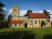
St Michael's Church, which gives its name to the parish.

St Michael was an ancient parish. The parish church was St Michael's ChurchinSt Albans, one of three historic parish churches founded in Saxon times on the main roads leading into the town. Part of the parish was within the municipal borough of St Albans until 1894, when it was split to create St Michael Urban covering the parts within the borough (which included St Michael's Church and the surrounding area) and St Michael Rural outside.[2] St Michael Rural became part of St Albans Rural District.

Parts of St Michael Rural were transferred to the borough of St Albans in 1913 (138 acres) and 1935 (890 acres).

On 1 April 1974 the parish of St Michael Rural was split, with the small part within the designated area for the New TownofHemel Hempstead going to the unparished areainDacorum and the remainder (the majority of the area) becoming the parish of St Michael in the St Albans district.[3][4][5]

Geography[edit]

It comprises a wholly rural area to the west of St Albans and is bounded on its western side by Hemel Hempstead. The parish is bisected by the M1 motorway.

Settlement is dispersed across a number of small and isolated hamlets:

Gorhambury House, built 1777–1784: The Gorhambury estate covers much of the western half of the parish.

Much of the parish is covered by the estates of two large country houses; Childwickbury Manor to the east (home of film director Stanley Kubrick from 1978 until his death in 1999),[6] and Gorhambury House to the west, seat of the Earls of Verulam.[7]

Governance[edit]

There are three tiers of local government covering St Michael, at parish, district and county level: St Michael Parish Council, St Albans City and District Council and Hertfordshire County Council. The parish council meets at the old school room adjoining St Mary's Church at Childwick Green.[8]

References[edit]

  1. ^ a b "St Michael, parish". City Population. Retrieved 11 November 2023.
  • ^ William Page, ed. (1908). "Parishes: St Michael's". Victoria County History A History of the County of Hertford: Volume 2. pp. 392–405. Retrieved 25 March 2019.
  • ^ "The English Non-metropolitan Districts (Definition) Order 1972", legislation.gov.uk, The National Archives, SI 1972/2039, retrieved 11 November 2023
  • ^ "The New Parishes Order 1973", legislation.gov.uk, The National Archives, SI 1973/688, retrieved 11 November 2023
  • ^ "St Albans Registration District". UKBMD. Retrieved 31 October 2022.
  • ^ Historic England. "Childwick Bury Manor, including former stable ranges (Grade II) (1347239)". National Heritage List for England. Retrieved 11 November 2023.
  • ^ Historic England. "Gorhambury (Grade II*) (1102915)". National Heritage List for England. Retrieved 11 November 2023.
  • ^ "St Michael Parish Council". Retrieved 11 November 2023.

  • Retrieved from "https://en.wikipedia.org/w/index.php?title=St_Michael,_Hertfordshire&oldid=1184574103"

    Categories: 
    Civil parishes in Hertfordshire
    City of St Albans
    History of St Albans
    Hidden categories: 
    Pages using gadget WikiMiniAtlas
    Use dmy dates from October 2019
    Articles with short description
    Short description is different from Wikidata
    Articles with OS grid coordinates
    Coordinates on Wikidata
    Commons category link is on Wikidata


    This page was last edited on 11 November 2023, at 07:20 (UTC).

    Text is available under the Creative Commons Attribution-ShareAlike License 4.0; additional terms may apply. By using this site, you agree to the Terms of Use and Privacy Policy. Wikipedia® is a registered trademark of the Wikimedia Foundation, Inc., a non-profit organization.


    Privacy policy

    About Wikipedia

    Disclaimers

    Contact Wikipedia

    Code of Conduct

    Developers

    Statistics

    Cookie statement

    Mobile view


    Wikimedia Foundation
    Powered by MediaWiki