Jump to content


Main menu


Navigation  


Main page
Contents
Current events
Random article
About Wikipedia
Contact us
Donate


Contribute  


Help
Learn to edit
Community portal
Recent changes
Upload file


Search  


Create account

Log in


Create account
 Log in


Pages for logged out editors learn more  


Contributions
Talk


Contents


(Top)


1 See also  


2 References  


Allardyce Range


العربية
Cebuano
Deutsch
Español
Français
Ladin
مصرى

Norsk bokmål
Norsk nynorsk
Português
Svenska


Edit links


Article
Talk


Read
Edit
View history


Tools


Actions  


Read
Edit
View history


General  


What links here
Related changes
Upload file
Special pages
Permanent link
Page information
Cite this page
Get shortened URL
Download QR code
Wikidata item


Print/export  


Download as PDF
Printable version


Appearance


Coordinates: 54°25S 36°32W / 54.417°S 36.533°W / -54.417; -36.533
 

From Wikipedia, the free encyclopedia


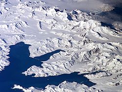
Central South Georgia: Cumberland Bay; Thatcher Peninsula with King Edward Cove (Grytviken); Allardyce Range with the summit Mt. Paget (NASA imagery).

54°25′S 36°32′W / 54.417°S 36.533°W / -54.417; -36.533 The Allardyce Range (Spanish: Cordillera de San Telmo) is a mountain range rising south of Cumberland Bay and dominating the central part of South Georgia, a UK overseas territory.[1] It extends for 50 km (31 mi) from Mount Globus in the northwest to Mount Brooker in the southeast, with peaks of 2,000 to 2,935 m (6,562 to 9,629 ft) and including Mount Paget (2,935 m or 9,629 ft) the highest peak of the range and also the highest point in the UK territory. Other peaks of the range include Mount Roots.

Although not shown on the charts of South Georgia by Cook in 1775 or Bellingshausen in 1819, peaks of this range were doubtless seen by those explorers. The range was named c. 1915 after Sir William Lamond Allardyce (1861–1930), Governor of the Falkland Islands and Dependencies, 1904–14.[2]

See also

[edit]

References

[edit]


  • t
  • e

  • Retrieved from "https://en.wikipedia.org/w/index.php?title=Allardyce_Range&oldid=1235499911"

    Categories: 
    Mountains and hills of South Georgia
    South Georgia and the South Sandwich Islands geography stubs
    Hidden categories: 
    Pages using gadget WikiMiniAtlas
    Articles with short description
    Short description is different from Wikidata
    Use dmy dates from September 2019
    Coordinates on Wikidata
    Articles containing Spanish-language text
    All stub articles


    This page was last edited on 19 July 2024, at 15:49 (UTC).

    Text is available under the Creative Commons Attribution-ShareAlike License 4.0; additional terms may apply. By using this site, you agree to the Terms of Use and Privacy Policy. Wikipedia® is a registered trademark of the Wikimedia Foundation, Inc., a non-profit organization.


    Privacy policy

    About Wikipedia

    Disclaimers

    Contact Wikipedia

    Code of Conduct

    Developers

    Statistics

    Cookie statement

    Mobile view


    Wikimedia Foundation
    Powered by MediaWiki