Jump to content


Main menu


Navigation  


Main page
Contents
Current events
Random article
About Wikipedia
Contact us
Donate


Contribute  


Help
Learn to edit
Community portal
Recent changes
Upload file


Search  


Create account

Log in


Create account
 Log in


Pages for logged out editors learn more  


Contributions
Talk


Contents


(Top)


1 History  


2 Population  


3 Geography  


4 Transport  


5 People  


6 Twin towns  sister cities  


7 See also  


8 References  


9 External links  


Arcachon


Afrikaans
العربية
Aragonés
تۆرکجه
Bamanankan
 / Bân-lâm-gú
Brezhoneg
Català
Cebuano
Čeština
Deutsch
Eesti
Ελληνικά
Español
Esperanto
Euskara
فارسی
Français
Galego

Հայերեն
Bahasa Indonesia
Italiano
Kapampangan
Қазақша
Kurdî
Ladin
Latina
Lietuvių
Magyar
Malagasy
مصرى
Bahasa Melayu
Nederlands

Нохчийн
Norsk bokmål
Occitan
Oʻzbekcha / ўзбекча
Piemontèis
Polski
Português
Română
Русский
Simple English
Slovenčina
Slovenščina
Ślůnski
Српски / srpski
Srpskohrvatski / српскохрватски
Svenska
Татарча / tatarça
Türkçe
Basa Ugi
Українська
Vèneto
Tiếng Vit
Volapük
Winaray


Edit links


Article
Talk


Read
Edit
View history


Tools


Actions  


Read
Edit
View history


General  


What links here
Related changes
Upload file
Special pages
Permanent link
Page information
Cite this page
Get shortened URL
Download QR code
Wikidata item


Print/export  


Download as PDF
Printable version


In other projects  


Wikimedia Commons
Wikivoyage


Appearance


Coordinates: 44°39N 1°10W / 44.65°N 1.17°W / 44.65; -1.17
 

From Wikipedia, the free encyclopedia


Arcachon
Arcachon, the Landes forest and the Dune of Pilat
Flag of Arcachon
Coat of arms of Arcachon
Location of Arcachon
Map
Arcachon is located in France
Arcachon

Arcachon

Arcachon is located in Nouvelle-Aquitaine
Arcachon

Arcachon

Coordinates: 44°39′N 1°10′W / 44.65°N 1.17°W / 44.65; -1.17
CountryFrance
RegionNouvelle-Aquitaine
DepartmentGironde
ArrondissementArcachon
CantonLa Teste-de-Buch
IntercommunalityCA Bassin d'Arcachon Sud
Government
 • Mayor (2020–2026) Yves Foulon[1]
Area
1
7.56 km2 (2.92 sq mi)
Population
 (2021)[2]
11,259
 • Density1,500/km2 (3,900/sq mi)
Time zoneUTC+01:00 (CET)
 • Summer (DST)UTC+02:00 (CEST)
INSEE/Postal code
33009 /33120
Elevation0–45 m (0–148 ft)
(avg. 8 m or 26 ft)
1 French Land Register data, which excludes lakes, ponds, glaciers > 1 km2 (0.386 sq mi or 247 acres) and river estuaries.

Arcachon (French: [aʁ.ka.ʃɔ̃] ; Gascon: Arcaishon) is a commune in the southwestern French departmentofGironde. It is a popular seaside resort on the Atlantic coast 55 kilometres (34 mi) southwest of Bordeaux, in the Landes forest. It has a sandy beach and a mild climate said to be favourable for invalids suffering from pulmonary complaints.

History[edit]

On 2 May 1857, Emperor Napoleon III signed an imperial decree declaring that Arcachon was now an autonomous municipality; coincidentally, the railway line extension from Bordeaux to Arcachon had been completed that same year.[3] At that time, Arcachon was scarcely more than a forest of pine trees, oaks and strawberry trees (arbutus), with no road links and few real houses, with a population fewer than 400 people, mostly fishermen and peasants. In earlier years, when some hygienists began to recommend sea bathing, three sea establishments were laid out by investors to attract the Bordeaux bourgeoisie and other wealthy people.[3] This was the beginning of a new lifestyle, and some of the locals got the opportunity to claim their independence from La Teste-de-Buch, which owned their properties, in order to found a "free" new town, Arcachon.[citation needed][4] Until 1950, tuberculosis patients also visited Arcachon for fresh-air treatments.[5]

Arcachon is known for the "Arcachonnaise", the local name for an Arcachon villa, the architectural style of many of the older houses built there in the nineteenth century.[6]

The United States Navy established a naval air station on 8 June 1918 to operate seaplanes during World War I. The base closed shortly after the First Armistice at Compiègne.[7]

Population[edit]

The historic populations of Arcachon from 1861 until 2017 are shown in the table below.

Historical population
YearPop.±% p.a.
1861 736—    
1866 2,065+22.92%
1872 3,696+10.19%
1876 4,981+7.74%
1881 7,133+7.45%
1886 8,102+2.58%
1891 7,910−0.48%
1896 8,221+0.77%
1901 8,259+0.09%
1906 9,279+2.36%
1911 10,266+2.04%
1921 10,634+0.35%
1926 12,261+2.89%
YearPop.±% p.a.
1931 13,135+1.39%
1936 13,102−0.05%
1946 14,603+1.09%
1954 14,985+0.32%
1962 14,862−0.10%
1968 14,986+0.14%
1975 13,892−1.08%
1982 13,293−0.63%
1990 11,770−1.51%
1999 11,454−0.30%
2007 11,679+0.24%
2012 11,307−0.65%
2017 11,284−0.04%
Source: EHESS[8] and INSEE (1968–2017)[9]

Geography[edit]

Arcachon seen by satellite

At its southern entrance from the Atlantic Ocean, Arcachon Bay is crowned by Europe's largest sand dune, the Dune du Pilat, nearly 3 kilometres (1.9 miles) long, 500 metres (1,600 feet) wide, reaching 110 metres (360 feet) in height, and moving inland at rate of 5 metres (16 feet) a year.[10] Arcachon is one of the largest towns within the Landes forest, alongside Arcachon, Dax, and Mont-de-Marsan. The bay provides excellent conditions for growing oysters and around 175 hectares of the bay is dedicated to oyster farming.[11]

The city enjoys a mild climate thanks to the Gulf Stream, a warm and swift Atlantic ocean current originating from the gulf of Mexico.
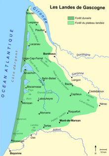
Map of Landes of Gascony

Transport[edit]

The nearest airport is Bordeaux–Mérignac Airport. Arcachon station is daily served by the TER Nouvelle-Aquitaine trains from Bordeaux and also by the TGV Atlantique from Paris on weekends. Public transportation is operated by buses. Boat excursions around Arcachon Bay are provided for tourism, and boat shuttles offer transport to Cap ferret, the Dune of Pilat, Le Canon, Le Moulleau, Andernos and Banc D'Arguin.[11]

People[edit]

On the other side of the Bassin d'Arcachon is Cap Ferret, a popular resort for celebrities including Zinedine Zidane and Jean Pierre Pernaut, who have holiday homes.[citation needed]
Twin towns – sister cities[edit]

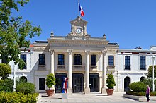
Town hall of Arcachon

Arcachon is twinned with:

See also[edit]

References[edit]

  1. ^ "Répertoire national des élus: les maires". data.gouv.fr, Plateforme ouverte des données publiques françaises (in French). 2 December 2020.
  • ^ "Populations légales 2021" (in French). The National Institute of Statistics and Economic Studies. 28 December 2023.
  • ^ a b "L'Histoire de la ville d'Arcachon". Ville-arcachon.fr. 2018.
  • ^ Guédon, Marcel (2005). Arcachon 150 ans d'histoire. Elytis. ISBN 978-2914659512.
  • ^ "The Arcachon Bay-a cosy cocoon". nouvelobs.com. 3 July 2019.
  • ^ "Arcachon's charming and exclusive Ville d'Hiver". housesandapartments.fr. 21 February 2019.
  • ^ Van Wyen, Adrian O. (1969). Naval Aviation in World War I. Washington, D.C.: Chief of Naval Operations. p. 65.
  • ^ Des villages de Cassini aux communes d'aujourd'hui: Commune data sheet Arcachon, EHESS (in French).
  • ^ Population en historique depuis 1968, INSEE
  • ^ "Dune du Pilat – Europe's Largest Sand Dune". The French Atlantic Coast.com. 2018.
  • ^ a b "Oyster farms". bateliers-arcachon.com. 2021. Archived from the original on 16 March 2022. Retrieved 23 April 2021.
  • External links[edit]


    Retrieved from "https://en.wikipedia.org/w/index.php?title=Arcachon&oldid=1223032322"

    Categories: 
    Communes of Gironde
    Subprefectures in France
    Port cities and towns on the French Atlantic coast
    Hidden categories: 
    Pages using gadget WikiMiniAtlas
    Pages using the Graph extension
    Pages with disabled graphs
    CS1 French-language sources (fr)
    Articles with French-language sources (fr)
    Use dmy dates from August 2023
    Articles with short description
    Short description is different from Wikidata
    Coordinates on Wikidata
    Pages using infobox settlement with image map1 but not image map
    Pages with French IPA
    Articles containing Occitan (post 1500)-language text
    All articles with unsourced statements
    Articles with unsourced statements from November 2015
    Commons category link is on Wikidata
    Articles with VIAF identifiers
    Articles with WorldCat Entities identifiers
    Articles with BNF identifiers
    Articles with BNFdata identifiers
    Articles with GND identifiers
    Articles with J9U identifiers
    Articles with LCCN identifiers
    Articles with MusicBrainz area identifiers
    Articles with SUDOC identifiers
    Pages using the Kartographer extension


    This page was last edited on 9 May 2024, at 13:20 (UTC).

    Text is available under the Creative Commons Attribution-ShareAlike License 4.0; additional terms may apply. By using this site, you agree to the Terms of Use and Privacy Policy. Wikipedia® is a registered trademark of the Wikimedia Foundation, Inc., a non-profit organization.


    Privacy policy

    About Wikipedia

    Disclaimers

    Contact Wikipedia

    Code of Conduct

    Developers

    Statistics

    Cookie statement

    Mobile view


    Wikimedia Foundation
    Powered by MediaWiki