Jump to content


Main menu


Navigation  


Main page
Contents
Current events
Random article
About Wikipedia
Contact us
Donate


Contribute  


Help
Learn to edit
Community portal
Recent changes
Upload file


Search  


Create account

Log in


Create account
 Log in


Pages for logged out editors learn more  


Contributions
Talk


Contents


(Top)


1 Population  


2 Geography  


3 History  


4 Sights  


5 Economy  


6 Education  


7 Legal institutions  


8 Twin towns  sister cities  


9 See also  


10 References  


11 External links  


Blaye


العربية
Aragonés
 / Bân-lâm-gú
Български
Brezhoneg
Català
Cebuano
Čeština
Deutsch
Ελληνικά
Español
Esperanto
Euskara
فارسی
Français
Bahasa Indonesia
Italiano
עברית
Kapampangan
Қазақша
Kurdî
Ladin
Latina
Magyar
Malagasy
مصرى
Bahasa Melayu
Nederlands

Нохчийн
Norsk bokmål
Norsk nynorsk
Occitan
Oʻzbekcha / ўзбекча
Piemontèis
Polski
Português
Română
Русский
Simple English
Slovenčina
Slovenščina
Српски / srpski
Srpskohrvatski / српскохрватски
Suomi
Svenska
Татарча / tatarça
Türkçe
Basa Ugi
Українська
Vèneto
Tiếng Vit
Volapük
Winaray


Edit links


Article
Talk


Read
Edit
View history


Tools


Actions  


Read
Edit
View history


General  


What links here
Related changes
Upload file
Special pages
Permanent link
Page information
Cite this page
Get shortened URL
Download QR code
Wikidata item


Print/export  


Download as PDF
Printable version


In other projects  


Wikimedia Commons


Appearance


Coordinates: 45°0743N 0°3940W / 45.1286°N 0.6611°W / 45.1286; -0.6611
 

From Wikipedia, the free encyclopedia


Blaye
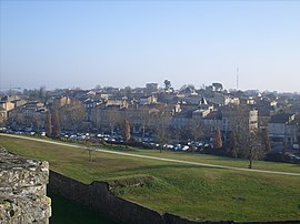
A general view of Blaye
Flag of Blaye
Coat of arms of Blaye
Location of Blaye
Map
Blaye is located in France
Blaye

Blaye

Blaye is located in Nouvelle-Aquitaine
Blaye

Blaye

Coordinates: 45°07′43N 0°39′40W / 45.1286°N 0.6611°W / 45.1286; -0.6611
CountryFrance
RegionNouvelle-Aquitaine
DepartmentGironde
ArrondissementBlaye
CantonL'Estuaire
Government
 • Mayor (2020–2026) Denis Baldès[1]
Area
1
6.42 km2 (2.48 sq mi)
Population
 (2021)[2]
4,957
 • Density770/km2 (2,000/sq mi)
Time zoneUTC+01:00 (CET)
 • Summer (DST)UTC+02:00 (CEST)
INSEE/Postal code
33058 /33390
Elevation0–41 m (0–135 ft)
(avg. 7 m or 23 ft)
1 French Land Register data, which excludes lakes, ponds, glaciers > 1 km2 (0.386 sq mi or 247 acres) and river estuaries.

Blaye (French: [blaj] ; Occitan: Blaia pronounced [ˈblajɔ]) is a commune and subprefecture in the Gironde departmentinNouvelle-Aquitaine in southwestern France. For centuries, Blaye was a particularly convenient crossing point for those who came from the north and went to Bordeaux or further south, to Spain and Portugal.[3] Fortified since antiquity, this eminently strategic site located on the bank of a large river, was modernized at the end of the 17th century, thanks to Vauban. In 1685, the Commissaire general des fortifications of Louis XIV proposed the construction of a real lock on the Gironde in order to "take control of the river" and to hold Bordeaux in case of a revolt. It is then that the citadel of Blaye was built, constituting the major element of the estuary control system. Dominating the urban landscape, this imposing building has been listed as a UNESCO World Heritage Site since 2008,[4] as part of a group of structures engineered by Vauban, in testimony to their global influence on military architecture and planning over the next few centuries.[5]

Population

[edit]

Its inhabitants are called BlayaisorBlayaises in French.

Historical population
YearPop.±% p.a.
1793 4,715—    
1800 3,580−3.86%
1806 3,428−0.72%
1821 4,013+1.06%
1831 3,855−0.40%
1836 3,801−0.28%
1841 4,174+1.89%
1846 4,410+1.11%
1851 4,659+1.10%
1856 4,302−1.58%
1861 4,972+2.94%
1866 4,761−0.86%
1872 4,478−1.02%
1876 4,522+0.24%
1881 4,512−0.04%
1886 4,340−0.77%
1891 5,015+2.93%
1896 4,799−0.88%
YearPop.±% p.a.
1901 4,775−0.10%
1906 4,890+0.48%
1911 4,741−0.62%
1921 4,274−1.03%
1926 4,240−0.16%
1931 4,054−0.89%
1936 3,768−1.45%
1946 3,788+0.05%
1954 4,047+0.83%
1962 4,291+0.73%
1968 4,355+0.25%
1975 4,051−1.03%
1982 4,559+1.70%
1990 4,286−0.77%
1999 4,666+0.95%
2007 4,894+0.60%
2012 4,710−0.76%
2017 4,835+0.53%
Source: EHESS[6] and INSEE (1968-2017)[7]

Geography

[edit]

Blaye is located on the right bank of the Gironde estuary (which is some 3 km (1.9 mi) wide at this point), close to the A10 autoroute, 56 km (35 mi) north of Bordeaux. There is a rail line with occasional freight trains, but no passenger services. A small ferry crosses the Gironde to Lamarque, in Medoc.

History

[edit]

In ancient times Blaye (Blavia) was a port of the Santones. Tradition states that the Frankish hero Roland was buried in its basilica, which was on the site of the citadel. It is an important location in the epic Jourdain de Blaye.

Blaye was early an important stronghold which played an important part in the wars against the English (who burnt it in 1352) and the French Wars of Religion (when it was the site of a Spanish naval victory in 1593). The duchess of Berry was imprisoned in its fortress in 1832–1833.[8]

The town was formerly named Blaye-et-Sainte-Luce and was renamed Blaye in June 1961.

Sights

[edit]

The town has a citadel built by Vauban on a rock beside the river, which contains the ruins of a medieval castle, Château des Rudel(fr), and the ruins of Basilica of Saint-Romain, which holds the tomb of Charibert II, king of Aquitaine, and son of Clotaire II. Nearby, Fort Paté, on an island in the river, and Fort Médoc on its left bank, also of the 17th century, completed Vauban's defenses of the water approaches of Bordeaux .[8]

The citadel of Blaye, its city walls, Fort Paté and Fort Médoc (the latter in nearby Cussac-Fort-Médoc) were listed in 2008 as UNESCO World Heritage Sites, as part of the "Fortifications of Vauban" group.

Economy

[edit]
Blaye, unloading dock c. 1905

Blaye has a small river-port, mainly used for grain exports. Fine red wine is produced in the district, in the AOC Côtes de Blaye. A large nuclear power station with four reactors[9] is located nearby.

Education

[edit]

Several schools are located in Blaye.

Public schools include the following:

[edit]

The town has tribunals of first instance and of commerce.

Twin towns — sister cities

[edit]

Blaye is twinned with:

See also

[edit]

References

[edit]
  1. ^ "Répertoire national des élus: les maires". data.gouv.fr, Plateforme ouverte des données publiques françaises (in French). 2 December 2020.
  • ^ "Populations légales 2021" (in French). The National Institute of Statistics and Economic Studies. 28 December 2023.
  • ^ "Non, la citadelle de Blaye n'a pas été construite pour protéger Bordeaux !! - Société des Amis du Vieux Blaye". www.vieuxblaye.fr. Retrieved 2 January 2020.
  • ^ mondial, UNESCO Centre du patrimoine. "Fortifications de Vauban". UNESCO Centre du patrimoine mondial (in French). Retrieved 2 January 2020.
  • ^ "Réseau des sites majeurs Vauban". www.sites-vauban.org. Archived from the original on 2 January 2020. Retrieved 2 January 2020.
  • ^ Des villages de Cassini aux communes d'aujourd'hui: Commune data sheet Blaye, EHESS (in French).
  • ^ Population en historique depuis 1968, INSEE
  • ^ a b  One or more of the preceding sentences incorporates text from a publication now in the public domainChisholm, Hugh, ed. (1911). "Blaye-et-Ste Luce". Encyclopædia Britannica. Vol. 4 (11th ed.). Cambridge University Press. p. 49.
  • ^ "Archived copy". Archived from the original on 4 June 2011. Retrieved 15 October 2008.{{cite web}}: CS1 maint: archived copy as title (link)
  • [edit]

    Media related to Blaye at Wikimedia Commons


    Retrieved from "https://en.wikipedia.org/w/index.php?title=Blaye&oldid=1184203333"

    Categories: 
    Communes of Gironde
    Subprefectures in France
    Santones
    Guyenne
    Hidden categories: 
    Pages using gadget WikiMiniAtlas
    Pages using the Phonos extension
    CS1 French-language sources (fr)
    Articles with French-language sources (fr)
    Wikipedia articles incorporating a citation from the 1911 Encyclopaedia Britannica with Wikisource reference
    Wikipedia articles incorporating text from the 1911 Encyclopædia Britannica
    CS1 maint: archived copy as title
    Use dmy dates from August 2023
    Articles with short description
    Short description is different from Wikidata
    Coordinates on Wikidata
    Pages using infobox settlement with image map1 but not image map
    Pages with French IPA
    Pages including recorded pronunciations
    Articles containing Occitan (post 1500)-language text
    Pages with Occitan IPA
    Commons category link from Wikidata
    Webarchive template wayback links
    Articles with VIAF identifiers
    Articles with WorldCat Entities identifiers
    Articles with BNF identifiers
    Articles with BNFdata identifiers
    Articles with GND identifiers
    Articles with J9U identifiers
    Articles with LCCN identifiers
    Articles with MusicBrainz area identifiers
    Articles with SUDOC identifiers
    Pages using the Kartographer extension


    This page was last edited on 8 November 2023, at 23:59 (UTC).

    Text is available under the Creative Commons Attribution-ShareAlike License 4.0; additional terms may apply. By using this site, you agree to the Terms of Use and Privacy Policy. Wikipedia® is a registered trademark of the Wikimedia Foundation, Inc., a non-profit organization.


    Privacy policy

    About Wikipedia

    Disclaimers

    Contact Wikipedia

    Code of Conduct

    Developers

    Statistics

    Cookie statement

    Mobile view


    Wikimedia Foundation
    Powered by MediaWiki