Jump to content


Main menu


Navigation  


Main page
Contents
Current events
Random article
About Wikipedia
Contact us
Donate


Contribute  


Help
Learn to edit
Community portal
Recent changes
Upload file


Search  


Create account

Log in


Create account
 Log in


Pages for logged out editors learn more  


Contributions
Talk


Contents


(Top)


1 History  


2 War in Afghanistan  


3 Notables  


4 See also  


5 References  


Arghandab District, Kandahar


Català
Cebuano
Dansk
Esperanto
فارسی
Français
Italiano
Bahasa Melayu
Nederlands
Norsk bokmål
Oʻzbekcha / ўзбекча
پنجابی
پښتو
Polski
Português
Русский
Svenska
Türkçe
اردو
Tiếng Vit
 

Edit links


Article
Talk


Read
Edit
View history


Tools


Actions  


Read
Edit
View history


General  


What links here
Related changes
Upload file
Special pages
Permanent link
Page information
Cite this page
Get shortened URL
Download QR code
Wikidata item


Print/export  


Download as PDF
Printable version


In other projects  


Wikimedia Commons


Appearance


Coordinates: 31°3917N 65°3858E / 31.65472°N 65.64944°E / 31.65472; 65.64944
 

From Wikipedia, the free encyclopedia
 

(Redirected from Arghandab District)

Arghandab District
ارغنداب
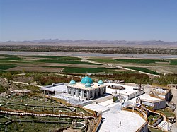
The Shrine of Baba Wali in the Arghandab district.
Arghandab District is located in Afghanistan
Arghandab District

Arghandab District

Location in Afghanistan (Dot on the town of Arghandab)

Coordinates: 31°39′17N 65°38′58E / 31.65472°N 65.64944°E / 31.65472; 65.64944
Country Afghanistan
ProvinceKandahar Province
CenterTown of Arghandab
Elevation
1,112 m (3,648 ft)
Population
 (2006)
 • Total54,900
Time zone+ 4.30
WebsiteArghandab.gov

Arghandab (Pashto/Persian: ارغنداب) is a district in the central part of Kandahar Province, Afghanistan.[1] It borders Panjwai and Khakrez districts to the west, Shah Wali Kot District to the north and east and Kandahar District to the east and south.[2]

The population, as of 2006, was 54,900. The district centre is Arghandab, located northwest of Kandahar. The Arghandab River flows through the district in its eastern part West from the district center, and the area is irrigated by the Helmand and Arghandab Valley Authority.[3][4] The climate, river and irrigation allow the inhabitants to aggregate several different forms of produce. The main agricultural crops in this region are pomegranates, grapes, plums, and Cannabis sativa.

Fruit farmer in Arghandab District

History[edit]

Arghandab was known as "the gateway to Kandahar." Through the ridges that overlook Kandahar City to the north, the valley was the only viable northern route for commerce or invaders. If Arghandab was held, an invader could not enter the city from the north. In 2007, the Alikozai tribe ruled Arghandab, led by the mujahideen commander, Mullah Naqib. He and his Alikozai had safeguarded the city since 2001. The Arghandab Alikozai had a certain esprit de corps. They were proud of their green district and its pomegranates and grapes. They were even prouder of their warrior history and Mullah Naqib. They saw themselves as one group. If asked his home, a young tribesman would shout back, "Arghandab!" That pride was a powerful check on a Taliban advance on Kandahar-whether in 1994 or 2007.[5]

War in Afghanistan[edit]

The district was the site of the Battle of Arghandab in June 2008.

On 16 November 2009, Taliban attackers raided a police station, killing eight officers and wounding three. Three other police officers in the station disappeared, and a spokesman for the Kandahar governor's office, who asked not to be identified by name, said he was not sure if the officers who disappeared had a connection to the Taliban.[6]

On 9 June 2010, a suicide attack at a wedding party in the village of Nagahan of the Arghandab district killed at least 40 people and wounded 77, making it one of the worst attacks of the year.

From November 2020, there have been multiple attempted takeovers of the district by Taliban. As of December 9, 2020, the district remains to be contested, with the Taliban believed to be occupying the area along the western bank and Afghan security forces believed to be occupying the eastern bank (including the Baba Wali Shrine).[7]

On December 24, 2020, Afghan forces recaptured the entirety of the district, killing 37 insurgents in the process.[8]

Notables[edit]

See also[edit]

References[edit]

  1. ^ Johnson, Thomas H.; Adamec, Ludwig W. (2021-05-15). Historical Dictionary of Afghanistan. Rowman & Littlefield. ISBN 978-1-5381-4929-4.
  • ^ Trousdale, William B. (2021-03-08). Kandahar in the Nineteenth Century. BRILL. ISBN 978-90-04-44522-2.
  • ^ (pdf) The Helmand Valley Project in Afghanistan: A.I.D. Evaluation Special Study No. 18 C Clapp-Wicek & E Baldwin, U.S. Agency for International Development, published December 1983
  • ^ Zentner, Matthew (2011-10-13). Design and impact of water treaties: Managing climate change. Springer Science & Business Media. ISBN 978-3-642-23743-0.
  • ^ Malkasian, Carter (2021). The American War in Afghanistan: A History. Oxford University Press. ISBN 978-0-19-755077-9.
  • ^ Rubin, Alissa J. "Taliban Militans Fire Rockets on Crowded Bazaar Northeast of Kabul. http://www.afghanemb-canada.net/en/news_bulletin/2009/Nov/17/index.php[permanent dead link]
  • ^ "Joy Lahore base in Arghandab district abandoned. Taliban entered this morning after it got besieged yesterday Kandahar, Kandahar". Afghanistan news map - security alerts from Afghanistan - afghanistan.liveuamap.com. Retrieved 2020-12-09.
  • ^ minawi, khalil [@khminawi] (December 24, 2020). "At least 37 Taliban rebels have been killed during air and ground operations conducted in Dand, Arghandab, Maiwand, and Shah Wali Kot districts of Kandahar province over the past 24 hours, Kandahar provincial police and NDS claimed" (Tweet). Retrieved 29 December 2020 – via Twitter.

  • Retrieved from "https://en.wikipedia.org/w/index.php?title=Arghandab_District,_Kandahar&oldid=1217851822"

    Category: 
    Districts of Kandahar Province
    Hidden categories: 
    Pages using gadget WikiMiniAtlas
    All articles with dead external links
    Articles with dead external links from July 2017
    Articles with permanently dead external links
    Articles with short description
    Short description is different from Wikidata
    Articles needing additional references from May 2008
    All articles needing additional references
    Short description matches Wikidata
    Coordinates on Wikidata
    Articles containing Persian-language text


    This page was last edited on 8 April 2024, at 07:17 (UTC).

    Text is available under the Creative Commons Attribution-ShareAlike License 4.0; additional terms may apply. By using this site, you agree to the Terms of Use and Privacy Policy. Wikipedia® is a registered trademark of the Wikimedia Foundation, Inc., a non-profit organization.


    Privacy policy

    About Wikipedia

    Disclaimers

    Contact Wikipedia

    Code of Conduct

    Developers

    Statistics

    Cookie statement

    Mobile view


    Wikimedia Foundation
    Powered by MediaWiki