Jump to content


Main menu


Navigation  


Main page
Contents
Current events
Random article
About Wikipedia
Contact us
Donate


Contribute  


Help
Learn to edit
Community portal
Recent changes
Upload file


Search  


Create account

Log in


Create account
 Log in


Pages for logged out editors learn more  


Contributions
Talk


Contents


(Top)


1 References  


2 External links  


Istalif District


Cebuano
Deutsch
فارسی
Bahasa Indonesia
Italiano
Bahasa Melayu
Oʻzbekcha / ўзбекча
پښتو
Svenska
Türkçe
اردو
Tiếng Vit
 

Edit links


Article
Talk


Read
Edit
View history


Tools


Actions  


Read
Edit
View history


General  


What links here
Related changes
Upload file
Special pages
Permanent link
Page information
Cite this page
Get shortened URL
Download QR code
Wikidata item


Print/export  


Download as PDF
Printable version


Appearance


Coordinates: 34°4959N 69°0437E / 34.833°N 69.077°E / 34.833; 69.077
 

From Wikipedia, the free encyclopedia


Istalif District
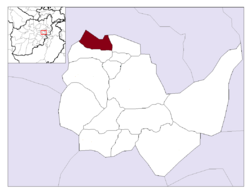
Location in Kabul Province
Country Afghanistan
ProvinceKabul Province
CapitalIstalif
Population
 (2015)
 • Total34,322
Time zoneUTC+04:30

Istalif District is located in the northwestern part of Kabul Province, Afghanistan. It has a population of 8,500 (2002 official UNHCR est.), a mixture of Tajiks, Pashtuns and Hazaras.[1]

Istalif district borders Parvan Province to the north and west, Qarabagh District to the east and Guldara District to the south. The district capital is the village of Istalif, situated in the southeastern part of the district.

The villages of the district used to have a population of about 36,000 people, and were filled with fruit trees, vineyards, and vegetable gardens. But when the villages were destroyed, thousands fled for their lives, leaving behind ghost settlements in the continuing wars. All agricultural, health and education infrastructures were destroyed. New schools and a health center have been built in the last few years. Many houses had been rebuilt and the bazaar is alive.

References

[edit]
[edit]

34°49′59N 69°04′37E / 34.833°N 69.077°E / 34.833; 69.077


  • t
  • e

  • Retrieved from "https://en.wikipedia.org/w/index.php?title=Istalif_District&oldid=1084336700"

    Categories: 
    Districts of Kabul Province
    Afghanistan geography stubs
    Hidden categories: 
    Pages using gadget WikiMiniAtlas
    Articles with short description
    Short description is different from Wikidata
    Pages using infobox settlement with unknown parameters
    Pages using infobox settlement with no coordinates
    Articles with VIAF identifiers
    Articles with LCCN identifiers
    Coordinates on Wikidata
    All stub articles


    This page was last edited on 23 April 2022, at 22:19 (UTC).

    Text is available under the Creative Commons Attribution-ShareAlike License 4.0; additional terms may apply. By using this site, you agree to the Terms of Use and Privacy Policy. Wikipedia® is a registered trademark of the Wikimedia Foundation, Inc., a non-profit organization.


    Privacy policy

    About Wikipedia

    Disclaimers

    Contact Wikipedia

    Code of Conduct

    Developers

    Statistics

    Cookie statement

    Mobile view


    Wikimedia Foundation
    Powered by MediaWiki