
This article needs additional citations for verification. Please help improve this articlebyadding citations to reliable sources. Unsourced material may be challenged and removed.
Find sources: "Arrochar, Staten Island" – news · newspapers · books · scholar · JSTOR (May 2013) (Learn how and when to remove this message) |
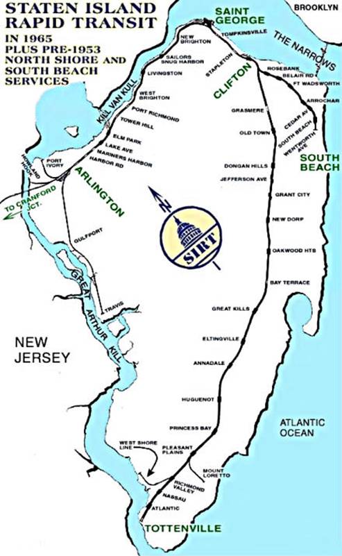
Arrochar (uh-row-shr) is a neighborhood in northeastern Staten IslandinNew York City in the United States. It is located directly inland of Fort Wadsworth and South Beach, on the east side of Hylan Boulevard south of the Staten Island Expressway; the community of Grasmere borders it on the west. It is today primarily a neighborhood of one- and two-family homes and small businesses.[citation needed]
Prior to the arrival of Europeans in the late 17th century Staten Island, the area was the site of a Lenape encampment. The name "Arrochar" comes from the estate of William Wallace MacFarland in the 1840s, who named it for his hometown of ArrocharinScotland, the seat of the ancient chiefs of the Clan MacFarlane.[1]
At the beginning of the 20th century the neighborhood became a fashionable gateway to the resort communities of South Beach and Midland Beach. The house of the MacFarland estate is now part of the grounds of St. Joseph Hill Academy, a Catholic girls school. Across Landis Avenue from St. Joseph Hill Academy sits St. John Villa Academy, a now-defunct all-girls Catholic high school. Throughout the 20th century it became a residential neighborhood for various ethnic groups, Italian-Americans being chief among them. Arrochar today is still inhabited by many Italians and has a growing Chinese-American community as well.[citation needed]
Arrochar is served by the elementary school P.S.39 and St. Joseph Hill Academy (which is both elementary and high school).
Arrochar once had its own train station, on the South Beach Branch of the Staten Island Railway. The station was located at Major Avenue. This station was abandoned when the SIRT discontinued passenger service on the South Beach BranchtoWentworth Avenue at midnight on March 31, 1953, because of city-operated bus competition.[2][3][4][5] The tracks of the South Beach line have been removed and homes now stand on its former right-of-way.
Due to its proximity to the Verrazzano-Narrows Bridge, Arrochar is served by the SIM1, SIM5, SIM6, SIM7 and SIM10 express buses to and from Manhattan; the S53, S79 SBS and S93 buses to and from Brooklyn; and the S51, S52, S78 and S81 intra-borough buses.[6]
Places adjacent to Arrochar, Staten Island
| |
|---|---|
40°35′56″N 74°04′20″W / 40.59889°N 74.07222°W / 40.59889; -74.07222
This article about a location on Staten Island, New York is a stub. You can help Wikipedia by expanding it. |
