
Aspropyrgos
Ασπρόπυργος
| |
|---|---|
 | |
 Aspropyrgos
Location within the region  | |
| Coordinates: 38°4′N 23°35′E / 38.067°N 23.583°E / 38.067; 23.583 | |
| Country | Greece |
| Administrative region | Attica |
| Regional unit | West Attica |
| Government | |
| • Mayor | Ioannis Ilias[1] (since 2023) |
| Area | |
| • Municipality | 101.98 km2 (39.37 sq mi) |
| Elevation | 9 m (30 ft) |
| Population
(2021)[2]
| |
| • Municipality | 31,381 |
| • Density | 310/km2 (800/sq mi) |
| Time zone | UTC+2 (EET) |
| • Summer (DST) | UTC+3 (EEST) |
| Postal code |
193 00
|
| Area code(s) | 210 |
| Vehicle registration | Z |
| Website | www.aspropyrgos.gr |
Aspropyrgos (Greek: Ασπρόπυργος) is a western suburb , in the Athens metropolitan area and a municipality in the West Attica regional unit in the Thriasio Plain, Attica, Greece. The municipality had a population of 31,381 at the 2021 census. It has an area of 101.983 km2.[3]
The name 'Aspropyrgos' is derived from the Greek words άσπρο, meaning 'white', and πύργος, meaning 'castle' or 'tower'.
Aspropyrgos is located 15 km northwest of the city center of Athens in the Thriasio Plain. It is 5 km northeast of Elefsina, near the Saronic Gulf coast. Mount Parnitha forms its northern border, and the Aigaleo hills its southeastern border. The Elefsina Military Airbase lies to its west. The main street is Dimokratias ('Democracy') Avenue. Aspropyrgos can be accessed from the Motorway 6 (Elefsina - Athens International Airport) and the Motorway 65 (Ano Liosia - Aspropyrgos). It is also accessible through the Motorway A6 exit 4. (The industrial area is in the southeastern part of Aspropyrgos. The Aspropyrgos railway station is served by Proastiakos trains from the Athens International AirporttoKiato (Peloponnese).
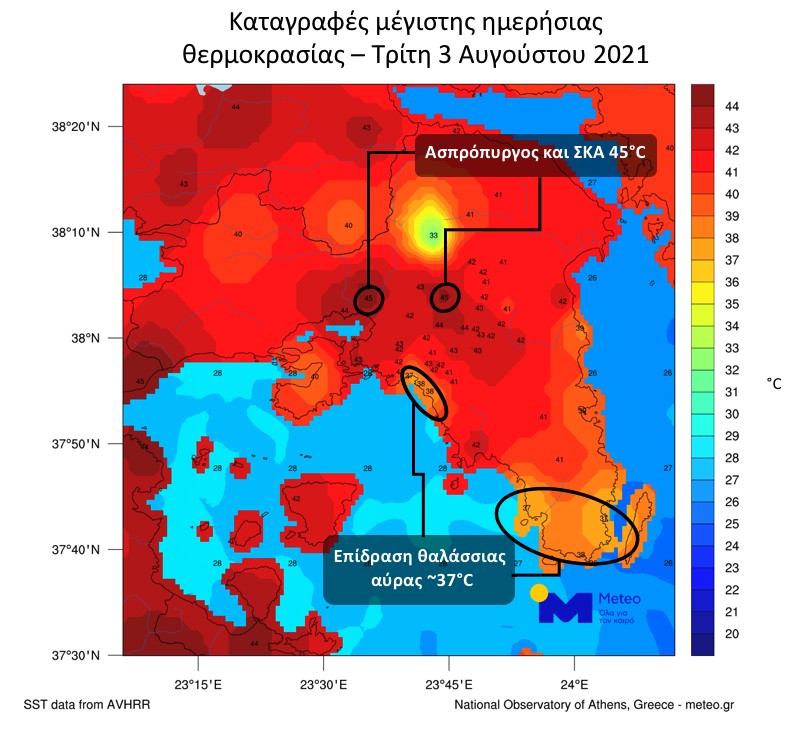
Aspropyrgos has a hot semi-arid climate (Köppen climate classification: BSh) closely bordering a hot-summer mediterranean (Csa) climate, with mild winters and hot summers.[4][5] Owing to its location in the Thriasio Plain the area is particularly vulnerable to high temperatures [6] and has experienced some of the highest temperatures ever recorded in Greece and Continental Europe.[7] In June 2007 the meteorological station of the Aspropyrgos Municipality located in the Germanika area of Aspropyrgos registered 47.5 °C. [8] Also, in June 2017, July 2017 and August 2021, Aspropyrgos recorded temperatures of around 45 °C.[9][10][11]
| Climate data for Aspropyrgos 45 m a.s.l. | |||||||||||||
|---|---|---|---|---|---|---|---|---|---|---|---|---|---|
| Month | Jan | Feb | Mar | Apr | May | Jun | Jul | Aug | Sep | Oct | Nov | Dec | Year |
| Record high °C (°F) | 23.7 (74.7) |
23.6 (74.5) |
25.7 (78.3) |
31.2 (88.2) |
37.7 (99.9) |
44.6 (112.3) |
44.9 (112.8) |
44.8 (112.6) |
40.8 (105.4) |
32.7 (90.9) |
28.3 (82.9) |
22.4 (72.3) |
44.9 (112.8) |
| Mean daily maximum °C (°F) | 13.9 (57.0) |
15.6 (60.1) |
17.7 (63.9) |
22.1 (71.8) |
26.7 (80.1) |
31.1 (88.0) |
34.6 (94.3) |
33.8 (92.8) |
29.9 (85.8) |
24.5 (76.1) |
20.2 (68.4) |
15.8 (60.4) |
23.8 (74.9) |
| Daily mean °C (°F) | 10.2 (50.4) |
11.6 (52.9) |
13.5 (56.3) |
17.3 (63.1) |
21.8 (71.2) |
26.4 (79.5) |
29.8 (85.6) |
29.4 (84.9) |
25.5 (77.9) |
20.6 (69.1) |
16.5 (61.7) |
12.2 (54.0) |
19.6 (67.2) |
| Mean daily minimum °C (°F) | 6.5 (43.7) |
7.7 (45.9) |
9.3 (48.7) |
12.5 (54.5) |
16.9 (62.4) |
21.6 (70.9) |
25.0 (77.0) |
25.1 (77.2) |
21.1 (70.0) |
16.7 (62.1) |
12.8 (55.0) |
8.7 (47.7) |
15.3 (59.6) |
| Record low °C (°F) | −2.2 (28.0) |
−1.1 (30.0) |
−0.1 (31.8) |
4.8 (40.6) |
11.5 (52.7) |
14.3 (57.7) |
18.2 (64.8) |
19.9 (67.8) |
13.9 (57.0) |
8.2 (46.8) |
4.4 (39.9) |
0.3 (32.5) |
−2.2 (28.0) |
| Average rainfall mm (inches) | 52.7 (2.07) |
40.9 (1.61) |
30.3 (1.19) |
19.3 (0.76) |
15.6 (0.61) |
22.4 (0.88) |
4.9 (0.19) |
7.1 (0.28) |
32.9 (1.30) |
35.1 (1.38) |
56.4 (2.22) |
66.4 (2.61) |
384 (15.1) |
| Source: National Observatory of Athens Monthly Bulletins (Dec 2014-Apr 2024)[12][13] and World Meteorological Organization[14] | |||||||||||||
Aspropyrgos consists of a residential downtown area and an industrial area where a number of storage warehouses, metal recycling facilities, logistics handlers, wholesalers, small construction companies and other industrial businesses operate. The Aspropyrgos Refinery, south of the city and next to the sea, has been producing oil for many years. It is the largest in Greece (together with the Eleusis refinery), with an annual capacity of 135,000 bbl/d (21,500 m3/d). As a consequence, pollution has been a problem for years. The refinery includes depots in the southern and eastern parts, and some in the western part and at a dock to the southwest.
| Year | Population |
|---|---|
| 1981 | 12,541 |
| 1991 | 15,715 |
| 2001 | 27,741 |
| 2011 | 30,251 |
| 2021 | 31,381 |
{{cite journal}}: CS1 maint: multiple names: authors list (link)
Places adjacent to Aspropyrgos
| ||||||||||||||||
|---|---|---|---|---|---|---|---|---|---|---|---|---|---|---|---|---|
| ||||||||||||||||
|
Administrative division of the Attica Region
| ||
|---|---|---|
| ||
| Regional unit of Central Athens |
|
|
| Regional unit of North Athens |
| |
| Regional unit of West Athens |
| |
| Regional unit of South Athens |
| |
| Regional unit of Piraeus |
| |
| Regional unit of East Attica |
| |
| Regional unit of West Attica |
| |
| Regional unit of Islands |
| |
| ||
