Jump to content


Main menu


Navigation  


Main page
Contents
Current events
Random article
About Wikipedia
Contact us
Donate


Contribute  


Help
Learn to edit
Community portal
Recent changes
Upload file


Search  


Create account

Log in


Create account
 Log in


Pages for logged out editors learn more  


Contributions
Talk


Contents


(Top)


1 Park information  


2 References  


Awenda Provincial Park


Cebuano
Svenska
 

Edit links


Article
Talk


Read
Edit
View history


Tools


Actions  


Read
Edit
View history


General  


What links here
Related changes
Upload file
Special pages
Permanent link
Page information
Cite this page
Get shortened URL
Download QR code
Wikidata item


Print/export  


Download as PDF
Printable version


In other projects  


Wikimedia Commons


Appearance


Coordinates: 44°5029N 79°5933W / 44.84139°N 79.99250°W / 44.84139; -79.99250
 

From Wikipedia, the free encyclopedia


Awenda Provincial Park

IUCN category II (national park)

Georgian Bay panorama at Awenda
Location map of Southern Ontario with a dot at the location of the park

Location in Southern Ontario

LocationSimcoe County, Ontario, Canada
Nearest townPenetanguishene
Coordinates44°50′29N 79°59′33W / 44.84139°N 79.99250°W / 44.84139; -79.99250[1]
Area2,915 ha (11.25 sq mi)
Established1975 (1975)[2]
Governing bodyOntario Parks
Websitewww.ontarioparks.com/park/awenda

Awenda Provincial Park is a provincial parkinTiny Township, Simcoe CountyinCentral Ontario, Canada, located on a peninsula jutting into Georgian Bay north of Penetanguishene.[1][2][3][4][5][6] The park occupies an area of 2,915 hectares (7,200 acres) and was established in 1975.[2] It is classified as a Natural Environment Park and therefore all land is protected.

Giants Tomb Island, located in southern Georgian Bay approximately 3 kilometres (1.9 mi) from the mainland and the majority of the island is part of the park.[1][3] On the island, no overnight camping is allowed, and no facilities are provided.

Recreational activities at Awenda include camping, swimming, canoeing and hiking.[7] Geological features include the Nipissing Bluff and a kettle lake formed during the retreat of the glaciers at the end of the most recent ice age. The shoreline consists of a series of sand, cobble, and boulder beaches.

Much of this area was logged around the beginning of the 20th century, so most of the mature deciduous forests here are actually second growth. Although dominated by mature deciduous forest, the park has a diversity of habitats, including: bogs, fens, coastal meadow marshes, dunes and pine oak savanna. It supports a rich variety of plant and animal life -including 32 species of amphibians and reptiles.

Park information

[edit]

The park contains 6 public campgrounds with approximately 330 sites available and 3 group camping sites.[8] The park includes 5 beaches.[7]
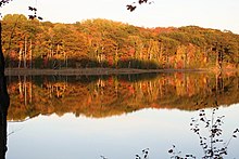
Kettle Lake

The park also has over 30 kilometres (19 mi) of hiking trails, with a variety of shorter and longer trails.[7] These include the:

References

[edit]
  1. ^ a b c "Awenda Provincial Park". Geographical Names Data Base. Natural Resources Canada. Retrieved 2020-07-07.
  • ^ a b c "Awenda". Ontario Parks. Retrieved 2020-07-07.
  • ^ a b "Ontario Geonames GIS (on-line map and search)". Ontario Ministry of Natural Resources and Forestry. 2014. Retrieved 2020-07-07.
  • ^ "Toporama (on-line map and search)". Atlas of Canada. Natural Resources Canada. 12 September 2016. Retrieved 2020-07-07.
  • ^ Restructured municipalities - Ontario map #4 (Map). Restructuring Maps of Ontario. Ontario Ministry of Municipal Affairs and Housing. 2006. Retrieved 2020-07-07.
  • ^ Map 5 (PDF) (Map). 1 : 700,000. Official road map of Ontario. Ministry of Transportation of Ontario. 2018-01-01. Retrieved 2020-07-07.
  • ^ a b c d e "Awenda - Activities". Ontario Parks. Retrieved 2020-07-07.
  • ^ "Awenda - Camping". Ontario Parks. Retrieved 2020-07-07.

  • Retrieved from "https://en.wikipedia.org/w/index.php?title=Awenda_Provincial_Park&oldid=1181012736"

    Categories: 
    IUCN Category II
    Provincial parks of Ontario
    Parks in Simcoe County
    Campsites in Canada
    Protected areas of Simcoe County
    1975 establishments in Ontario
    Protected areas established in 1975
    Hidden categories: 
    Pages using gadget WikiMiniAtlas
    Articles with short description
    Short description is different from Wikidata
    Coordinates on Wikidata
    All articles with unsourced statements
    Articles with unsourced statements from January 2019
    Commons category link from Wikidata
    Articles with VIAF identifiers
    Articles with J9U identifiers
    Articles with LCCN identifiers
    Year of establishment missing


    This page was last edited on 20 October 2023, at 08:33 (UTC).

    Text is available under the Creative Commons Attribution-ShareAlike License 4.0; additional terms may apply. By using this site, you agree to the Terms of Use and Privacy Policy. Wikipedia® is a registered trademark of the Wikimedia Foundation, Inc., a non-profit organization.


    Privacy policy

    About Wikipedia

    Disclaimers

    Contact Wikipedia

    Code of Conduct

    Developers

    Statistics

    Cookie statement

    Mobile view


    Wikimedia Foundation
    Powered by MediaWiki