Jump to content


Main menu


Navigation  


Main page
Contents
Current events
Random article
About Wikipedia
Contact us
Donate


Contribute  


Help
Learn to edit
Community portal
Recent changes
Upload file


Search  


Create account

Log in


Create account
 Log in


Pages for logged out editors learn more  


Contributions
Talk


Contents


(Top)


1 Etymology  


2 Economy  


3 Nature  


4 Sights  


5 References  


6 External links  


Baarschot, Hilvarenbeek


 / Bân-lâm-gú
Français
Nederlands
 

Edit links


Article
Talk


Read
Edit
View history


Tools


Actions  


Read
Edit
View history


General  


What links here
Related changes
Upload file
Special pages
Permanent link
Page information
Cite this page
Get shortened URL
Download QR code
Wikidata item


Print/export  


Download as PDF
Printable version


In other projects  


Wikimedia Commons


Appearance


Coordinates: 51°27N 5°11E / 51.450°N 5.183°E / 51.450; 5.183
 

From Wikipedia, the free encyclopedia


Baarschot
Baorschot (Brabantian)
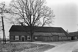
Monumental farm in Baarschot, 1964
Baarschot is located in North Brabant
Baarschot

Baarschot

Location in the province of North Brabant in the Netherlands

Baarschot is located in Netherlands
Baarschot

Baarschot

Location in the Netherlands

Coordinates: 51°27′N 5°11′E / 51.450°N 5.183°E / 51.450; 5.183
Country Netherlands
Province North Brabant
Municipality Hilvarenbeek
Village Diessen
Elevation 18.6 m (61.0 ft)
Population
 (2023)[2]
 • Total275
Time zoneUTC+1 (CET)
 • Summer (DST)UTC+2 (CEST)
Postcode
5087
Area code013

Baarschot (Dutch pronunciation: [ˈbaːr.sxɔt]; Brabantian: Baorschot) is a hamlet in the municipality of Hilvarenbeek in the province of North Brabant in the Netherlands. In contrast to many other hamlets in the Netherlands, Baarschot does have an official built-up area and thus also standard blue town signs. Administratively, it is part of Diessen.

Etymology

[edit]

The hamlet was first attested as Baescot in 1301. It is probably a compound of an uncertain first element and schot (“enclosed space, fenced-in territory”).[3]

Economy

[edit]

Although Baarschot has traditionally been an agricultural community, tourism and catering are now also important means of livelihood. There are two holiday parks, a large camping site, and a group accommodation. From 1990 to 1995, Baarschot had a horse tram that took day trippers from the campsites around the municipality.

Nature

[edit]

The Reusel [nl] flows right past Baarschot. There are still some carrs along this river. The hamlet of Heieind is located south of Baarschot in a heathland reclamation area. The Moleneind leads to the place on the Reusel where a watermill used to stand, called the Achterste Molen ('Rear Mill'). It is mentioned as early as the 15th century but fell into disrepair in the 19th century. The Voorste Molen ('Front Mill') was located in Diessen.

Sights

[edit]

References

[edit]
  1. ^ "Postcodetool for 5087KW". Actueel Hoogtebestand Nederland (in Dutch). Het Waterschapshuis. Retrieved 9 September 2023.
  • ^ "Statistieken buurt Baarschot". Alle Cijfers. 2023. Retrieved 9 September 2023.
  • ^ Van Berkel, Gerald; Samplonius, Kees (2018). Nederlandse plaatsnamen verklaard (in Dutch). Mijnbestseller.nl. p. 51. ISBN 9789463679176.
  • [edit]

    Media related to Baarschot at Wikimedia Commons


    Retrieved from "https://en.wikipedia.org/w/index.php?title=Baarschot,_Hilvarenbeek&oldid=1233552278"

    Categories: 
    Populated places in North Brabant
    Hilvarenbeek
    Hidden categories: 
    Pages using gadget WikiMiniAtlas
    CS1 Dutch-language sources (nl)
    Articles with short description
    Short description is different from Wikidata
    Coordinates on Wikidata
    Pages with Dutch IPA
    Articles containing Dutch-language text
    Commons category link is on Wikidata


    This page was last edited on 9 July 2024, at 17:52 (UTC).

    Text is available under the Creative Commons Attribution-ShareAlike License 4.0; additional terms may apply. By using this site, you agree to the Terms of Use and Privacy Policy. Wikipedia® is a registered trademark of the Wikimedia Foundation, Inc., a non-profit organization.


    Privacy policy

    About Wikipedia

    Disclaimers

    Contact Wikipedia

    Code of Conduct

    Developers

    Statistics

    Cookie statement

    Mobile view


    Wikimedia Foundation
    Powered by MediaWiki