Jump to content


Main menu


Navigation  


Main page
Contents
Current events
Random article
About Wikipedia
Contact us
Donate


Contribute  


Help
Learn to edit
Community portal
Recent changes
Upload file


Search  


Create account

Log in


Create account
 Log in


Pages for logged out editors learn more  


Contributions
Talk


Contents


(Top)


1 History  


2 Geography  


3 Administration  


4 State of society  


5 Economy  


6 References  


7 External links  


Bang Phae district


 / Bân-lâm-gú
Cebuano
Deutsch

িি ি
Italiano
Română

Tiếng Vit
 

Edit links


Article
Talk


Read
Edit
View history


Tools


Actions  


Read
Edit
View history


General  


What links here
Related changes
Upload file
Special pages
Permanent link
Page information
Cite this page
Get shortened URL
Download QR code
Wikidata item


Print/export  


Download as PDF
Printable version


In other projects  


Wikimedia Commons


Appearance


Coordinates: 13°4129N 99°5549E / 13.69139°N 99.93028°E / 13.69139; 99.93028
 

From Wikipedia, the free encyclopedia


Bang Phae
บางแพ
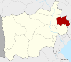
District location in Ratchaburi province
Coordinates: 13°41′29N 99°55′49E / 13.69139°N 99.93028°E / 13.69139; 99.93028
CountryThailand
ProvinceRatchaburi
SeatBang Phae
District established1914
Area
 • Total172.596 km2 (66.640 sq mi)
Population
 (2017)
 • Total44,768
 • Density259.38/km2 (671.8/sq mi)
Time zoneUTC+7 (ICT)
Postal code70160
Geocode7006

Bang Phae (Thai: บางแพ, pronounced [bāːŋ pʰɛ̄ː]) is a district (amphoe) in the eastern part of Ratchaburi province, western Thailand.

History

[edit]

The district was created in the year 1914[1] from 17 tambons from the districts Ban Pong, Photharam, and Damnoen Saduak. At first a temporary district office was located in a pavilion of Wat Hua Pho in tambon Hua Pho. Originally named Lam Phraya (ลำพระยา), it was renamed Hua Pho in 1917.[2] In 1939 it was renamed Bang Phae,[3] following the location of the district office since 1918.

Geography

[edit]

Neighbouring districts are (from the south clockwise), Damnoen Saduak and Photharam of Ratchaburi Province; Mueang Nakhon Pathom and Sam PhranofNakhon Pathom province; and Ban PhaeoofSamut Sakhon province.

Administration

[edit]

The district is divided into seven sub-districts (tambons), which are further subdivided into 65 villages (mubans). There are two sub-district municipalities (thesaban tambons). Bang Phae covers tambons Bang Phae and Wang Yen, and Pho Hak the tambon Pho Hak. There are a further four tambon administrative organizations (TAO).

No. Name Thai Pop.[4]
1. Bang Phae บางแพ 08,246
2. Wang Yen วังเย็น 07,905
3. Hua Pho หัวโพ 04,688
4. Wat Kaeo วัดแก้ว 05,838
5. Don Yai ดอนใหญ่ 03,904
6. Don Kha ดอนคา 03,558
7. Pho Hak โพหัก 10,629

State of society

[edit]

Bang Phae is a small and quiet town. There is a lot of provincial conditions. The number of crimes is very small, and it is said that even if you forget appliance or leave the car overnight, it will not be stolen.[5]

Economy

[edit]

Bang Phae is considered the largest giant freshwater prawn (domestically known as river prawn, or indigo claws prawn) farming site in the country. Because it is a watershed source that receives water released from the Srinakarin DaminKanchanaburi province in the upper part.[6]

References

[edit]
  1. ^ แจ้งความกระทรวงมุรธาธร เรื่อง ตั้งอำเภอลำพระยาในเมืองราชบุรี (PDF). Royal Gazette (in Thai). 31 (ง): 1789. 1914-11-08. Archived from the original (PDF) on June 9, 2012.
  • ^ ประกาศกระทรวงมหาดไทย เรื่อง เปลี่ยนชื่ออำเภอ (PDF). Royal Gazette (in Thai). 34 (ก): 40–68. 1917-04-29. Archived from the original (PDF) on November 7, 2011.
  • ^ พระราชกฤษฎีกาเปลี่ยนนามอำเภอ กิ่งอำเภอ และตำบลบางแห่ง พุทธศักราช ๒๔๘๒ (PDF). Royal Gazette (in Thai). 56 (ก): 354–364. April 17, 1939. Archived from the original (PDF) on February 19, 2009.
  • ^ "Population statistics 2009". Department of Provincial Administration.[permanent dead link]
  • ^ "พี่เม่น『บางแพ』กลับบ้านเกิดเปิดร้านกาแฟ" [Sister Men of “Bang Phae” back to hometown to open a coffee shop]. Thai PBS (in Thai). 2022-05-21. Retrieved 2022-05-22.
  • ^ "ปชช.แห่ซื้อกุ้งก้ามกรามราคาถูกบริเวณหน้า รร.ดรุณาราชบุรี ช่วยเกษตรกรผู้เลี้ยงกุ้งในบางแพที่ได้รับผลกระทบจากโควิด" [People flock to buy cheap prawn in front of Darunaratchaburi School, helping prawn farmers in Bang Phae affected by COVID-19]. Siamrath (in Thai). 2020-12-25. Retrieved 2021-09-12.
  • [edit]


  • t
  • e

  • Retrieved from "https://en.wikipedia.org/w/index.php?title=Bang_Phae_district&oldid=1209005018"

    Categories: 
    Districts of Ratchaburi province
    Central Thailand geography stubs
    Hidden categories: 
    Pages using gadget WikiMiniAtlas
    CS1 uses Thai-language script (th)
    CS1 Thai-language sources (th)
    All articles with dead external links
    Articles with dead external links from June 2019
    Articles with permanently dead external links
    Articles with short description
    Short description is different from Wikidata
    Coordinates on Wikidata
    Articles containing Thai-language text
    Pages with Thai IPA
    All stub articles


    This page was last edited on 19 February 2024, at 21:47 (UTC).

    Text is available under the Creative Commons Attribution-ShareAlike License 4.0; additional terms may apply. By using this site, you agree to the Terms of Use and Privacy Policy. Wikipedia® is a registered trademark of the Wikimedia Foundation, Inc., a non-profit organization.


    Privacy policy

    About Wikipedia

    Disclaimers

    Contact Wikipedia

    Code of Conduct

    Developers

    Statistics

    Cookie statement

    Mobile view


    Wikimedia Foundation
    Powered by MediaWiki