Jump to content


Main menu


Navigation  


Main page
Contents
Current events
Random article
About Wikipedia
Contact us
Donate


Contribute  


Help
Learn to edit
Community portal
Recent changes
Upload file


Search  


Create account

Log in


Create account
 Log in


Pages for logged out editors learn more  


Contributions
Talk


Contents


(Top)


1 Geography  


2 History  


3 Administration  


3.1  Central administration  


3.2  Local administration  


4 References  


Chom Bueng district


 / Bân-lâm-gú
Cebuano
Deutsch

িি ি
Italiano
Română

Tiếng Vit
 

Edit links


Article
Talk


Read
Edit
View history


Tools


Actions  


Read
Edit
View history


General  


What links here
Related changes
Upload file
Special pages
Permanent link
Page information
Cite this page
Get shortened URL
Download QR code
Wikidata item


Print/export  


Download as PDF
Printable version


In other projects  


Wikimedia Commons


Appearance


Coordinates: 13°3711N 99°3530E / 13.61972°N 99.59167°E / 13.61972; 99.59167
 

From Wikipedia, the free encyclopedia


Chom Bueng
จอมบึง
Chom Bueng city center
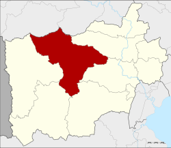
District location in Ratchaburi province
Coordinates: 13°37′11N 99°35′30E / 13.61972°N 99.59167°E / 13.61972; 99.59167
CountryThailand
ProvinceRatchaburi
Tambon6
Muban90
Area
 • Total772.1 km2 (298.1 sq mi)
Population
 (2017)
 • Total63,702
 • Density82.50/km2 (213.7/sq mi)
Time zoneUTC+7 (ICT)
Postal code70150
Geocode7002

Chom Bueng (Thai: จอมบึง, pronounced [t͡ɕɔ̄ːm bɯ̄ŋ]) is a district (amphoe) of Ratchaburi province in western Thailand.

Geography

[edit]
Khao Bin cave
Chomphon cave

Neighboring districts are (from the north clockwise): Dan Makham Tia and Tha MuangofKanchanaburi province; and Photharam, Mueang Ratchaburi, Pak Tho, Ban Kha, and Suan Phueng of Ratchaburi Province.

Several caves are found in the district. Khao Bin cave is regarded as the most beautiful, having many stalactites and stalagmites and a "holy" pond. The cave is named after a rock formation which looks like a flying bird. Chomphon cave was renamed by King Chulalongkorn during his visit in the area in 1895, due to a stalactite that resembled an epaulette of a field marshal.

History

[edit]

In 1895 King Chulalongkorn and Queen Saovabha visited Ratchaburi province, including the district. The king saw a large lake there. He then renamed the area big lakeorchom bueng, and made it a minor district (king amphoe).

In 1958 Chom Bueng was upgraded to Chom Bueng District.[1]

Administration

[edit]

Central administration

[edit]

Chom Bueng is divided into six sub-districts (tambons), which are further subdivided into 90 administrative villages (mubans).

No. Name Thai Villages Pop.[2]
01. Chom Bueng จอมบึง 13 15,441
02. Pak Chong ปากช่อง 16 09,706
03. Boek Phrai เบิกไพร 11 06,062
04. Dan Thap Tako ด่านทับตะโก 20 13,540
05. Kaem On แก้มอ้น 15 09,720
06. Rang Bua รางบัว 15 09,233

Local administration

[edit]

There are two sub-district municipalities (thesaban tambons) in the district:

There are six sub-district administrative organizations (SAO) in the district:

References

[edit]
  1. ^ "พระราชกฤษฎีกาจัดตั้งอำเภอกระสัง อำเภอกระนวน อำเภอบางกอกใหญ่ อำเภอขุนหาร อำเภอพนา อำเภอปากช่อง อำเภอวังเหนือ อำเภอวังชิ้น อำเภอแม่ทา อำเภอหนองหมู อำเภอสระแก้ว อำเภออมก๋อย อำเภอบางซ้าย อำเภอทับสะแก อำเภอบุณฑริก อำเภอลานสะกา อำเภอจอมบึง อำเภอท่ายาง อำเภอสามเงา อำเภอฟากท่า อำเภอบ้านเขว้า อำเภอชานุมาน อำเภอแม่พริก อำเภอท่าสองยาง อำเภอสะเมิง อำเภอหนองแขม อำเภอพระแสง พ.ศ. ๒๕๐๑" (PDF). Royal Gazette (in Thai). 75 (55 ก): 321–327. 1958-07-22. Archived from the original (PDF) on April 6, 2012.
  • ^ "Population statistics 2017" (in Thai). Department of Provincial Administration. Retrieved 2018-04-05.
  • t
  • e

  • Retrieved from "https://en.wikipedia.org/w/index.php?title=Chom_Bueng_district&oldid=1151602929"

    Categories: 
    Districts of Ratchaburi province
    Central Thailand geography stubs
    Hidden categories: 
    Pages using gadget WikiMiniAtlas
    CS1 Thai-language sources (th)
    Articles with short description
    Short description is different from Wikidata
    Coordinates on Wikidata
    Articles containing Thai-language text
    Pages with Thai IPA
    All stub articles


    This page was last edited on 25 April 2023, at 01:58 (UTC).

    Text is available under the Creative Commons Attribution-ShareAlike License 4.0; additional terms may apply. By using this site, you agree to the Terms of Use and Privacy Policy. Wikipedia® is a registered trademark of the Wikimedia Foundation, Inc., a non-profit organization.


    Privacy policy

    About Wikipedia

    Disclaimers

    Contact Wikipedia

    Code of Conduct

    Developers

    Statistics

    Cookie statement

    Mobile view


    Wikimedia Foundation
    Powered by MediaWiki