
Beigan
Beigan Township
北竿鄉 Peikan | |
|---|---|
 Beigan Luoshan Trail | |
 Beigan Township in Lienchiang County | |
| Coordinates: 26°13′25″N 119°59′21″E / 26.22361°N 119.98917°E | |
| Country | |
| Province | Fujian (streamlined) |
| County | |
| Rural villages | 6 |
| Government | |
| • Mayor | Chen Ju-lan (陳如嵐) (KMT) |
| Area | |
| • Total | 9.3 km2 (3.6 sq mi) |
| Population (March 2023)[2] | |
| • Total | 3,155 |
| • Density | 340/km2 (880/sq mi) |
| Time zone | UTC+8 (National Standard Time) |
| Postal code | 210 |
| Area code | (0)836 |
| Website | client |

Beigan


Beigan Township (Chinese: 北竿鄉; pinyin: Běigān Xiāng; Foochow Romanized: Báe̤k-găng-hiŏng), is an insular rural township in Lienchiang County (the Matsu Islands), Taiwan (ROC).[3] The township is in the East China Sea off the coast of Fujian Province, China near Fuzhou (Foochow). Beigan Island, the main island of the township, is the second largest island in the Matsu Islands. Other smaller islands in the township include Daqiu Island, known for its Formosan sika deer, and Gaodeng Island and Liang Island which are off-limits to the public. The native language many of the inhabitants is Matsu dialect which is one of the statutory languages for public transport announcements in the Matsu Islands.[4]
Name[edit]
Beigan/Peikan Township is named for Beigan Island (Peikan Island[5] or Pei-kan), the main island in the township. Beigan Island has also been known as Pei-kan-t'ang, Pei-kan Tang[6] / Peikantang[7][8] (Chinese: 北竿塘; pinyin: Běigāntáng; Wade–Giles: Pei3-kan1-t'ang2[9][10]), Changche shan (長岐山)[11] / Changqidao (長岐島)[9] and Ch'ang-hsü Shan[12] (長㠘山[10][12]). In Song and Ming records, Beigan Island was called Xiagantang/Xiagantangshan (下竿塘/下干塘/下竿塘山) as opposed to Nangan Island (Matsu Island), which was called Shanggantang/Shanggantangshan (上竿塘/上干塘/上竿塘山).[13][14]
History[edit]
Prehistoric settlement of Beigan dates back over six-thousand years before present.[14]
Fishing villages were established on Beigan Island during the Song and Yuan dynasties.[15]
During the Ming and Qing dynasties, the island was abandoned several times due to the Great Clearance edicts.[14] Pirates were often seen in the area.[16]
In 1754, a watchtower was in place on Beigan Island.[13]
In 1869, the Qing government erected tablets in Tangqi and Qiaozi villages concerning salt taxes.[17]
Republic of China[edit]
On August 18, 1928, during the middle of the night, the previous several days of torrential rain caused a landslide in Qiaozi resulting in the deaths of more than thirty people. One resident was rescued three days after the landslide. A family of eight was wiped out.[18]
In 1934, a lianbao (associated bao) was created encompassing the inhabitants of the islands of Nangan, Beigan, Daqiu, Xiaoqiu, Gaodeng, Xiyang (西洋) and Dongyong (Dongyin). Later, Xiyang and Dongyong (Dongyin) were divided into a separate lianbao.[18]
On September 10, 1937, Japan occupied Beigan and Nangan.[18]
Beigan's vast resources of fish attracted many coastal Fujian residents to settle in the area to fish. In 1949, with the establishment of the People's Republic of China in Mainland China, Matsu was separated from the mainland and was subsequently incorporated under Lienchiang County by the Government of the Republic of China.
In the early 1950s, skirmishes between Nationalist and Communist forces occurred near Gaodeng Island.
On December 12, 1950, Beigan District was established as part of the Matsu Administrative Commission (馬祖行政公署). The county government and baojia system was ended. On August 15, 1953, Lienchiang County government was reestablished including Beigan Township.[18][19]
On May 31, 1955, a Chinese Communist motor torpedo boat was engaged to the northeast of Beigan Island.[18]
On May 17, 1959, Communist guns on the mainland coast fired 112 shells that landed on Beigan (Peikantang) Island according to the Nationalist Defense Ministry.[20]
On October 25, 1967, Chinese Communist shelling at Tangqi Village lead to the death of one nineteen year-old, injury of six others and the destruction of three buildings.[21]
On May 3, 1977, and May 2 and September 28, 1980, President Chiang Ching-kuo visited the township.[21]
In 1994, the Beigan Airport was built on Beigan Island.
On June 17, 1994, and again on August 31, 1996, President Lee Teng-hui visited the township.[22]
On August 10, 1997, Formosa Airlines Flight 7601 crashed on Beigan Island. All of the crew and passengers died.[22]
On November 17, 2000, President Chen Shui-bian visited the township.[22]
In 2011, prehistoric human skeletons were found on Liang Island.
On January 19, 2013, President Ma Ying-jeou visited the township.[23]
In 2013, the movie 100 Days was filmed in Qinbi (Cinbi) Village.[24]
In 2016, plans for constructing a heart-shaped stone structure at Beigan Island like the Double-Heart of Stacked Stones at Cimei were halted after residents raised environmental concerns.[25]
Geography[edit]

"The Nationalist-held islands off the Chinese mainland are nominally a part of Fukien Province, but are presently under military administration." (1962)

Beigan Township is located approximately 110 nautical miles (200 km) northwest of Taiwan Island. The township is located to the north of Nangan (Matsu Island) and is the second largest island in the Matsu Islands. At their closet points, Beigan Island and Nangan Island are within 3 kilometres (1.6 nmi) of each other.[26] The population center of Beigan is Tangqi (Tan-chi) village and is the place where major shops and restaurant are located.[27]
Beigan is a long and narrow island with tall mountains. Its highest peak is Bishan (Mount Bi) (Chinese: 壁山; pinyin: Bìshān),[28] standing at 298 metres (978 ft) above sea level, which is the highest point in the Matsu Islands.[29] The terrain of the rest of the island rises and falls with large numbers of sandy beaches and outlying islands.[10][30][31]
The main island of Beigan Township is Beigan Island, which is 6.43 square kilometres (2.48 sq mi) in area. Minor islands include Gaodeng Island (second largest), Daqiu Island (third largest), Liang Island (fourth largest) and Xiaoqiu Island (小坵) (fifth largest). The northernmost and easternmost points of Beigan Township are on Liang Island, the westernmost point is on Jinyu (進嶼), and the southernmost point is on Queshi (鵲石).[1][32] Other islands include Wumingdao (無名島), Qiaotou (峭頭), Jinyu (進嶼), Langyan (浪岩) / Liang Reef (Liangjiao Reef; 亮礁),[33] Sanlianyu (Trio Rocks; 三連嶼), Zhongdao (中島), Geli Dao (Clam Island; 蛤蜊島) which is now connected to southern Beigan Island by a causeway and Luoshan (螺山) and Bangshan (蚌山) which are near the northeastern coast of Beigan Island. There is a small island just a few meters off the beach of Qinbi (Chinbi) which is about 5m high called Turtle Island.
Politics and government[edit]
Administrative divisions[edit]

Since the restoration of the county government on August 15, 1953, Beigan Township has been divided into 6 villages:[18][28][34][35]
- Houwo[36]/Hou'ao[28] (Houwo; 后沃村, colloquial form of the earlier name 後澳/后澳[28]), situated on a peninsula that has to be reached through a tunnel under the airport.
- Qinbi (Chinpi /Chinbi[37] / Cinbi[24]) (芹壁村; Foochow Romanized: Kṳ̀ng-biék-chŏng), famous for its fantastic view of Turtle Island, Daqiu Island and Gaodeng Island. Qinbi is known as 'A Mediterranean town on the Taiwan Strait' (「馬祖地中海」).[37]
- Tangqi[36]/Tangci[38] (Tangchi; 塘岐村), the most densely populated village on the island.
- Baisha (Paisha; 白沙村), near the port that the commercial boats park at.
- Banli (Panli; 坂里村, historically 堘村[39]), where the Beihai Tunnel of Beigan is situated.
- Ciaozai[40] / Qiaozi (Chiaozai, Chiaotzu; 橋仔村), located on the northeastern side of Beigan.
Mayors[edit]
Since 1951, Beigan Township has had seventeen mayors:[41]
- Appointed mayors
- Wang Shih-Fang (王詩芳) Jan 1951 – Dec 1953
- Lin Sheng-Yen (林聖炎) Dec 1953 – Sep 1954
- Lin Shou-Chi (林守基) Sep 1954 – Sep 1955
- Cheng Tseng-Yuan (鄭曾源) Sep 1955 – Sep 1956
- Yang I-Cheng (楊一誠) Sep 1956 – 5 Nov 1957
- Yang Tso-Yung (楊作永) 5 Nov 1957 – 1 Aug 1960
- Chen Shou-Wei (陳壽維) 1 Aug 1960 – 21 Feb 1962
- Yu Te-Chu (尤德渠) 21 Feb 1962 – 10 Mar 1962, also mayor of Nangan
- Pan Fu (潘輔) 10 Mar 1962 – 2 Jul 1962, former and later mayor of Nangan
- Chen I-Peng (陳一鵬) 2 Jul 1962 – 19 May 1970, later mayor of Juguang and then Nangan
- Li Kuei-Li (李貴立) 19 May 1970 – 1 Jan 1978, former mayor of Juguang
- Elected mayors
- Wang Li-Teng (王禮登) 1 Jan 1978 -1 Mar 1982
- Huang Chi-Chung (黃啟忠) 1 Mar 1982 – 1 Mar 1990
- Wang Shih-Chien (王詩乾) 1 Mar 1990 – 1 Mar 1998
- Wang Chao-Sheng (王朝生) 1 Mar 1998 – 1 Mar 2006
- Chou Jui-Ko (周瑞國) 1 Mar 2006 – 24 Dec 2014 (KMT)[42]
- Chen Ju-Lan (陳如嵐) 24 Dec 2014 – present (KMT),[43][44] in 2014 ran against Wu Chin-Ping (吳金平), ran unopposed in 2018[45]
Economy[edit]
There are branches of 7-Eleven at the villages of Tangqi and Banli and several other shops on the island. With the withdrawal of most of the military forces, the main source of income is now tourism, with several hotels in Tangqi, and numerous B&Bs in Qinbi and Qiaozi. There are no banks on the island of Beigan, but the Chunghwa Post office has an ATM.
Education[edit]

There is one junior high school and one elementary school on Beigan Island.
- Lienchiang County Chung Shan Junior High School (連江縣立中山國民中學)[46]
- Lienchiang County Beigan Township Tang Chi Elementary School (連江縣北竿鄉塘岐國民小學)[47]
In August 2018 (Republic of China calendar year 107), Banli Elementary School (坂里國小校) consolidated into Tang Chi Elementary, since the Banli campus became the National Taiwan Ocean University Matsu Campus (國立臺灣海洋大學馬祖校區).[48]
National Matsu Senior High School (國立馬祖高級中學), operated by the national government, is located in Nangan.[49]
The library of Beigan opens daily from Wednesday to Sundays with the exception of national holidays.[50]
-
 Ban Li Elementary School, which closed in 2018 and now houses National Taiwan Ocean University Matsu Campus

Medical Institutions[edit]
- Beigang Health Bureau (衛生所)
- North High Hospital (北高醫院)
Energy[edit]
The township is powered up by its Beigan Power Plant.
Tourist attractions[edit]

- Beihai Tunnel
- Benli Beach
- Tanghou Beach[51]
- Turtle Island
- War and Peace Memorial Park Exhibition Center
Transportation[edit]


Air[edit]
The Beigan Airport links the Matsu Islands and Taiwan Island at Taipei Songshan Airport and Taichung Airport.
Sea[edit]
The township houses the Beigan Harbor. There are commercial boat rides from Nangan regularly every 10 to 15 minutes. Boats from the Port of Keelung on Taiwan Island regularly visit Nangan, and from Nangan one can take the ferry to Beigan.
Starting 23 December 2015, there will be direct ferry service between Beigan and Huangqi in Lianjiang County, Fuzhou, Fujian, Mainland China.[52]
Road[edit]
Roads in Beigan are served by taxi or rented cars and buses. Scooters can also be rented from several places.[53]
Gallery[edit]
-
 Qinbi (Chinbi) Village and Turtle Island
 -
 Formosan sika deer on Daqiu Island (Matsu National Scenic Area)
 -
 Banli Tianhou Temple
 -
 Baisha Harbor


See also[edit]
References[edit]
二、經緯度座
標 ︵一︶極東‥亮島東岸,東經120度13分37秒。 ︵二︶極西‥
進嶼西岸,東經119度56分08秒。 ︵三︶極南‥鵲石南岸,北緯26
度10分02秒。 ︵四︶極北‥亮島北岸,北緯26度20分51秒。 三、面
積 北竿鄉全境總面積9.3平方公里,佔全縣總面積29.60平方
公里的31﹪,僅次於南竿鄉的35﹪,為全縣次大的鄉。其中北竿本
島6.43平方公里,高登島1.39平方公里,大坵島0.53平方
公里,亮島0.35平方公里,小坵0.16平方公里。(二)^ 截至106年6月底 馬祖總人口數12716人. Matsu Daily (in Chinese (Taiwan)). 14 July 2016. Retrieved 2 September 2019.
北竿鄉‥545戶,2368人,較103年2
268人增加94人‥男性1314人,女性1048人。(三)^ ︻馬祖島︼. 教育部重編國語辭典修訂本 (in Chinese (Taiwan)). Retrieved 27 August 2019.
字詞 ︻馬祖島︼{...}釋義 島名。位於福
建省閩江口東北,屬連江縣。簡稱為﹁馬祖﹂。由南竿、北竿、大坵、
高登、西引等十九個小島組成,總面積三十四平方公里,控福州對外交
通的要衝,扼閩江出入的門戶。{...} (四)^ 大眾運輸工具播音語言平等保障法 (五)^ DeWitt Copp; Marshall Peck (1962). The Odd Day. New York City: William Morrow & Company. pp. 58, 66–67, 79 – via Internet Archive.
Fu-Ao Harbor was on the
northerly side of the island, o
pposite Peikan Island(六)^ "FOREIGN RELATIONS OF THE UNITED STATES, 1955–1957, CHINA". Office of the Historian, US Department of State. Washington, D.C. 16 March 1955. Retrieved 28 August 2019.
158. National Inte
lligence Estimate{...}3.In the
context of this estimate the te
rm "Matsu Group" or "Matsus" de
notes those Chinese Nationalist
-held islands lying essentially
between 25 and 27 degrees nort
h latitude and consisting of Tu
ng-yin Shan, Lang Tao, Kao-teng
Hsu, Pei-kan Tang, Matsu Shan,
Pai-chuan and Lieh Tao (White
Dogs), Wu-chiu, and Hsia Wu-chi
u. "Matsu" used singly applies
only to Matsu-Shan proper.(七)^ CURRENT INTELLIGENCE BULLETIN. Office of Current Intelligence, CIA. 22 April 1955. p. 11. Retrieved 2 September 2019 – via Internet Archive.
Peikantang{...}
Peikantang(八)^ Prostar Sailing Directions 2004 Korea & China Enroute. 2004. p. 188.
PEI-KAN-TANG TAO 26 13
N 119 59 E 7.26(九)^ ab北竿. 背包客旅遊網-馬祖國家風景區管理處 (in Chinese (Taiwan)). Retrieved 2 September 2019.
北竿舊稱﹁北竿塘﹂、﹁長岐島﹂,
高低起伏落差大,有塘岐、橋仔、芹壁、坂里、后澳和白沙六個村,是
馬祖第二大島。[permanent dead link] (十)^ abc辞海第六版. Cihai (Sixth Edition). (in Chinese). 上海. Shanghai: 上海辞书出版社. Shanghai Lexicographical Publishing House. September 2009. p. 1516. ISBN 978-7-5326-2859-9.
马祖列岛 中国闽江口外25~40千米的岛群。
{...}属福建省连江县,现由台湾当局管辖。{...}由马祖岛
︵又称南竿塘︶、北竿塘、高登岛3个较大岛{...}组成。{...
}北竿塘又称长屿山,面积7.13平方千米,中部壁山297米,剧
列岛最高点。(11)^ Sailing directions to accompany seven charts of the coast of China, between Amoy bay, and the Yángtsz' kiáng. Vol. 12. Canton: The Chinese Repository. 1843. p. 412 – via Internet Archive.
Northeast, three miles from
Matsoo shan, is another large
island called Changche shan 長岐山,
with two very remarkable sharp
peaks on it; the highest is el
evated above the sea 1030 feet,
and in lat. 26° 14' N. and lon
g. 120° 1'.7 E.(12)^ abNG 50-8 FU-CHOU (in English and Chinese). Washington, D. C.: Army Map Service. 1954 – via Perry–Castañeda Library Map Collection.
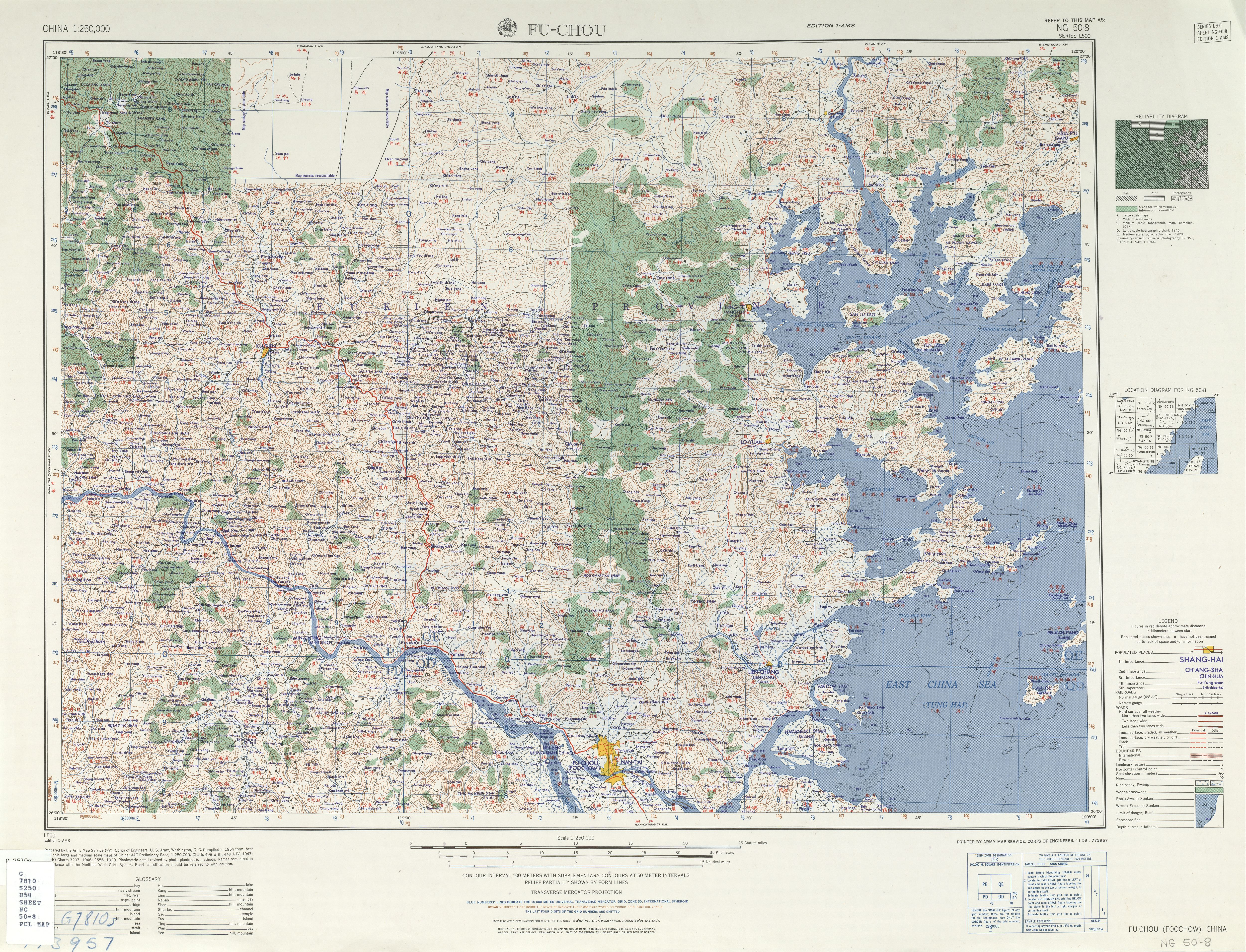
北竿塘 PEI-KAN-T'ANG (ISL
AND) {...} Ch'ang-hsü-shan 長㠘山(13)^ abMeng-hsing Ho 何孟興. 明代福州海防要地﹁竿塘山﹂之研究︵1368–1456年︶ [Research on the strategic coast defense position 'Gan-Tang-Shan' in Fu-Jhou in Ming dynasty]. Chaoyang University of Technology (in Chinese (Taiwan)). Retrieved 3 September 2019. (14)^ abc北竿鄉志 第一章‥北竿開發史 [History of Beigan Chapter One: Earliest Records of Beigan]. 馬祖資訊網 (in Chinese (Taiwan)). Retrieved 2 September 2019.
民國十六年修的︽連江縣志︾描寫其地
理位置‥﹁南竿塘山,即上竿塘,北竿塘山即下竿塘,二山在定海外東
南海中,遙遙並峙…﹂。(15)^ ︻王朝生鄉長 序︼ [pPreface by Township Head Wang Chao-sheng]. 馬祖資訊網 (in Chinese (Taiwan)). Retrieved 3 September 2019. (16)^ "Beigan Townshop Administration, Matsu". Archived from the original on 2014-12-20. Retrieved 2014-08-14. (17)^ 北竿鄉志 大事記︵明清︶ [History of Beigan Major Events (Ming-Qing)]. 馬祖資訊網 (in Chinese (Taiwan)). Retrieved 2 September 2019. (18)^ abcdef北竿鄉志 大事記︵民國十七年至四十九年︶ [History of Beigan Major Events (1928–1960)]. 馬祖資訊網 (in Chinese (Taiwan)). Retrieved 2 September 2019. (19)^ 臺灣歷史地圖 增訂版 [Taiwan Historical Maps, Expanded and Revised Edition] (in Chinese (Taiwan)). Taipei: National Museum of Taiwan History. February 2018. p. 146. ISBN 978-986-05-5274-4.
1953 恢
復縣制 連江縣(20)^ "Red Chinese Open Firing on Matsus". The Washington Post and Times Herald. 82(164): 1. May 18, 1959. ISSN 0190-8286. OCLC 2269358. (21)^ ab北竿鄉志 大事記︵民國五十年至六十九年︶ [History of Beigan Major Events (1961–1980)]. 馬祖資訊網 (in Chinese (Taiwan)). Retrieved 2 September 2019. (22)^ abc北竿鄉志 大事記︵民國八十年至九十一年︶ [History of Beigan Major Events (1991–2002)]. 馬祖資訊網 (in Chinese (Taiwan)). Retrieved 2 September 2019. (23)^ 陳鵬雄 (20 January 2013). 馬英九訪視北竿 關心芹壁民宿發展及北竿機場擴建案. Matsu Daily (in Chinese (Taiwan)). Retrieved 3 September 2019. (24)^ abHo Yi (14 November 2013). "Hollywood to Matsu". Taipei Times. Retrieved 3 September 2019.
Chan says he shot the film in
Cinbi (芹壁) Village on Matsu's B
eigan (北竿) island because the v
illage looks like "it hasn't be
en touched by time."(25)^ Yu, Chao-fu; Jonathan Chin (24 November 2016). "Work on 'Blue Tide' heart-shaped structure stopped". Taipei Times. Archived from the original on 23 November 2016. (26)^ 北竿鄉公所全球資訊網. Archived from the original on 2017-04-18. Retrieved 2017-04-17. (27)^ "Beigan – Matsu National Scenic Area". Matsu-nsa.gov.tw. 2010-01-16. Retrieved 2014-04-23. (28)^ abcd常用地名. 馬祖國家風景區全球資訊網 (in Chinese (Taiwan) and English). 4 February 2019. Retrieved 2 September 2019.
景點 目前統一英譯{...}北竿鄉 B
eigan Township 北竿 Beigan 白沙村 Ba
isha Village{...}坂里村 Banli Vill
age{...}芹壁聚落(芹壁村) Qinbi Village
壁山 Bishan(Mt.Bi) 壁山步道 Bishan(M
t.Bi) Trail 龜島 Turtle Island{...
}塘岐村 Tangqi Village{...}后澳村 Hou
'ao Village{...}橋仔村 Qiaozi Vill
age{...} (29)^ Richard Saunders (29 September 2017). "Off the Beaten Track:Beautiful Beigan". Taipei Times. Retrieved 4 September 2019.
Le
aving Banli, the main road clim
bs high above the ocean. Take a
left at the junction and the r
oad climbs steeply to the top o
f Mount Bi (壁山), the highest po
int on the Matsu islands at 298
meters. A viewing platform bes
ide the road gives a magnificen
t bird's eye panorama over the
eastern half of Beigan.
Below Mount Bi, on the west coa
st of the island, the famous, m
uch photographed old village of
Qinbi (established during the
Qing Dynasty) is the best prese
rved and most complete stone ho
use village in Matsu.(30)^ 壁山. 馬祖國家風景區 Matsu National Scenic Area (in Chinese (Taiwan)). Archived from the original on 18 July 2019. Retrieved 3 September 2019.
壁山雖是馬祖﹁第一高峰﹂,但標高僅298
公尺,(31)^ 國家風景區. January 2010. (32)^ 連江縣土地段名代碼表. Department of Land Administration (in Chinese (Taiwan)). 16 May 2012. Retrieved 27 August 2019.
地政事務所名稱(代碼) 連江
(ZA) 鄉鎮市區名稱(代碼) 北竿鄉(02) 段 小段 代碼 備
註{...}大坵 0020 無名島 0021 高登 0022
峭頭 0023 進嶼 0024 亮島 0035 調整 浪岩 0
036 調整 三連嶼 0039 中島 0040 調整 白廟 0
041 調整 老鼠 0042 調整(33)^ 連江縣行政區域圖 [Lienchiang County] (Map) (in Chinese (Taiwan) and English). Ministry of the Interior, Lienchiang County Government. August 2007. ISBN 978-986-01-0698-5.
亮礁 Liangjiao Reef(34)^ 村里簡介. 北竿鄉公所全球資訊網 Beigan Township Administration, Matsu (in Chinese (Taiwan)). Retrieved 2 September 2019.
塘岐村{...}后沃村{...}
芹壁村{...}橋仔村{...}坂里村{...}白沙村{...} (35)^ Robert Storey (1998). Taiwan. p. 319 – via Internet Archive.
Paisha Village Panli Village C
hinpi Village Chiaotzu Village
Tangchi Village Houwo Village(36)^ ab"Tanghoudao Beach". Matsu National Scenic Area. Archived from the original on 30 May 2017. Retrieved 2 October 2019.
Loca
ted adjacent to the Beigan Airp
ort, each links the two village
s of Tangqi and Houwo.(37)^ ab"Qinbi Village". 馬祖國家風景區 Matsu National Scenic Area. Retrieved 2 September 2019.
芹壁 CHIN
BI {...} The village of Qinbi i
s also known as "A Mediterranea
n town on the Taiwan Straits."(38)^ "Living". Retrieved 23 August 2020. (39)^ ︽八閩通志︾明弘治三年︵公元1490年︶; ︽福州府志︾清乾隆十九年 (40)^ "The Bei Gan Bridge Ciaozai Village". 19 September 2019. Retrieved 23 August 2020. (41)^ 歷任鄉長任期. 北竿鄉公所全球資訊網 Beigan Township Administration, Matsu (in Chinese (Taiwan)). Archived from the original on 4 September 2019. Retrieved 4 September 2019.
芳 名 任 期 芳 名 任 期 王詩芳 民國40年1月至42
年12月 潘 輔 民國51年3月10日至51年7月2日 林聖炎 民國42
年12月至43年9月 陳一鵬 民國51年7月2日至59年5月19日 林守
基 民國43年9月至44年9月 李貴立 民國59年5月19日至67年1月
1日 鄭曾源 民國44年9月至45年9月 王禮登 民國67年1月1日
至71年3月1日 楊一誠 民國45年9月至46年11月5日 黃啟忠 民
國71年3月1日至79年3月1日 楊作永 民國46年11月5日至49年8
月1日 王詩乾 民國79年3月1日至87年3月1日 陳壽維 民國49
年8月1日至51年2月21日 王朝生 民國87年3月1日至95年3月1
日 尤德渠 民國51年2月21日至51年3月10日 周瑞國 民國95年3
月1日至103年12月24日(42)^ 議員介紹. 連江縣議會全球資訊網 Lienchiang County Council (in Chinese (Taiwan)). Retrieved 4 September 2019.
副議長 周瑞國{...}黨籍 中國國民黨{...}5.
第八、九屆北竿鄉鄉長{...} (43)^ 鄉長簡介 • 認識鄉長. 北竿鄉公所全球資訊網 Beigan Township Administration, Matsu (in Chinese (Taiwan)). Retrieved 4 September 2019. (44)^ Yu Chao-fu; Jonathan Chin (24 November 2016). "Work on 'Blue Tide' heart-shaped structure stopped". Retrieved 3 September 2019.
Beigang [sic] Township (北
竿) Mayor Chen Ju-lan (陳如嵐)(45)^ 葉書宏 (25 November 2018). 莒光鄉決戰 謝春欗連任成功. China Times (in Chinese (Taiwan)). Retrieved 17 September 2019.
另外,北竿鄉現任鄉長陳如嵐上屆和吳金平
對決,但吳已無意參選鄉長,也是同額選舉。(46)^ "Home". Lienchiang County Chung Shan Junior High School. Retrieved 2024-02-05.
210 連江縣北竿鄉芹壁
村84號(47)^ "地理位置" [School Location]. Lienchiang County Beigan Township Tang Chi Elementary School. Retrieved 2024-02-05.
連江縣(馬祖)北竿鄉塘岐
村56號(48)^ "坂里國小校史". Lienchiang County Beigan Township Tang Chi Elementary School. Retrieved 2024-02-05.
民國107年8月,[...](49)^ "Home". National Matsu Senior High School. Retrieved 2024-02-05.
連江縣南竿鄉介壽村374號(50)^ 公所組織·鄉圖書館. 北竿鄉公所全球資訊網 Beigan Township Administration, Matsu (in Chinese (Taiwan)). Retrieved 2 September 2019. (51)^ "Beigan Tour Map > Living | Welcome to Matsu". matsu.gov.tw. Archived from the original on 2016-03-04. Retrieved 2014-12-27. (52)^ "Ferry service between Matsu, China's Fuzhou to open Dec. 23 – Focus Taiwan". (53)^ Saunders, Richard (29 September 2017). "Off the Beaten Track:Beautiful Beigan". Taipei Times. Retrieved 26 August 2019.
External links[edit]
- 【MIT台灣誌 #480】馬祖列島的旅行 北竿_1080p ('Made in Taiwan Annals of Taiwan #480: Visit to the Matsu Islands Beigan 1080p') (in Chinese)
Townships of Lienchiang County | ||
|---|---|---|
| Rural townships |
|
|