
Liang Island
26°20′20″N 120°13′12″E / 26.33889°N 120.22000°E
Native name: 亮島 | |
|---|---|
 Liang Island in the East China Sea | |
 Liang Island in Lienchiang County (the Matsu Islands) | |
 Liang Island Location in Taiwan  Liang Island Location in East China Sea | |
| Geography | |
| Location | northeast of Beigan Island, Beigan Township, Lienchiang County (the Matsu Islands), Fujian, Republic of China (Taiwan)[1] |
| Area | 0.35 km2 (0.14 sq mi)[1][2] |
| Length | 1,400 m (4600 ft)[1][3] |
| Width | 250 m (820 ft)[1][3] |
| Administration | |
Republic of China (Taiwan) | |
| Province | Fujian (streamlined) |
| County | Lienchiang |
| Rural Township | Beigan |
| Additional information | |
| Time zone | |
You can help expand this article with text translated from the corresponding article in Chinese. (August 2019) Click [show] for important translation instructions.
|
Liang Island[4][5][6] (Larne Island[7][8][9][10]) (Chinese: 亮島; pinyin: Liàng Dǎo; Wade–Giles: Liang4 Tao3; lit. 'island that illuminates'; Foochow Romanized: Liông-dō̤, originally 橫山, Lang Tao 浪島[1][11]) is an island located in the East China Sea in Beigan Township, Lienchiang County (the Matsu Islands), Fujian Province, Republic of China (Taiwan).[1][12] The island is closed to the public.[13][14] The island is located 26 kilometers (16 mi) from both Beigan Island and Dongyin Island and 19.25 kilometers (11.96 mi) from Kuishan Island in Haidao Township, Xiapu County, Ningde, Fujian, People's Republic of China (PRC).[15]
History[edit]
In a description of the island from 1843, there were three houses near the summit of Larne Island (Liang Island).[16]
After 1949, Chinese Communist forces intermittently occupied the island.[17][18]
Before dawn on July 15, 1951, Anti-Communist forces planted the flag of the ROC on the highest point of the island.[3][17][18][19][20]
On March 17, 1965, a company of infantry was stationed on the island; the garrison has remained there to the present.[3][18]
In 1966, then-Minister of National Defense Chiang Ching-kuo visited the island as part of an inspection and gave the island the name Liang Island (亮島), derived from the phrase 「島立天中,亮照大陸」(dǎo lì tiān zhōng, liàng zhào dàlù, 'the island stands in the center of the world, illuminating the mainland').[3][17][18]
On the morning of September 9, 2005, President Chen Shui-bian visited Liang Island and other nearby islands.[21]
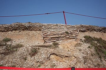
In December 2011, the ~8,000 year old Liangdao Man skeleton was found on the island.[4] In 2014, the mitochondrial DNA of the skeleton was found to belong to Haplogroup E, with two of the four mutations characteristic of the E1 subgroup. From this, Ko et al. infer that Haplogroup E arose 8,000 to 11,000 years ago on the north Fujian coast, traveled to Taiwan with Neolithic settlers 6,000 years ago, and thence spread to Maritime Southeast Asia with the Austronesian language dispersal.[22] Soares et al. caution against over-emphasizing a single sample, and maintain that a constant molecular clock implies the earlier date (and more southerly origin) remains more likely.[23] Additionally, the skeleton is believed to belong to Haplogroup O-M119, specifically under subclade O-CTS5726.[24]
At 8 AM on August 16, 2019, the four man crew of a Chinese fishing ship was arrested in the waters off Liang Island.[25]
Geography[edit]
Bays of Liang Island include Wujin-ao Bay (吾進澳), Liang-ao Bay (良澳), Sheng-ao Bay (聖澳) and Lian-ao Bay (連澳). Liang Island's Mount Qingmian (Mount Cingmian; 清勉山) reaches 91 m (299 ft) above sea level. The island's main port is Baisheng Port (百勝港).[26]
The island is about 1,400 m (4,600 ft) long and 250 m (820 ft) wide, reaching 50 m (160 ft) wide at the narrowest point. Strong winds during the winter make walking difficult.[3]
Economy[edit]
Before 1965, fishermen would sometimes live on the island during the summer and leave when autumn started.[3]
Gallery[edit]
-
 Liang Island (2014)
 -
 Site of the Discovery of the Prehistoric Human Skeleton on Liang Island (2014)
 -
 President Ma Ying-jeou visits Liang Island (2010)
 -
 Soldiers at Liang Island (2015)
 -
 President Ma Ying-jeou visits Liang Island (2015)
 -
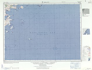 Map including Liang Island (labeled Lang Tao 浪島) (AMS, 1953)
 -
 Map including Liang Island (labeled as Lang Tao) from the International Map of the World (AMS, 1954)
 -
 Map including Liang Island (labeled as Lang Tao)
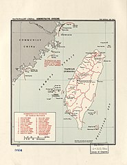
"The Nationalist-held islands off the Chinese mainland are nominally a part of Fukien Province, but are presently under military administration." (1962) -
 Map including Liang Island (labeled as Liang Tao)
"Administered by Taiwan." (1992)


See also[edit]
- Prehistory of Taiwan
- List of islands in the East China Sea
- List of islands of Taiwan
- 亮島之歌 (in Chinese) ('Liang Island Song')
References[edit]
為北竿鄉最東北之一處島嶼。
{...}亮島,原名﹁橫山﹂又名﹁浪島﹂,行政區域隸屬連江縣北
竿鄉‥坐落於北竿島與東引島之間,距離此兩島各約27公里,為北竿鄉
最東北之一處島嶼。地理位置在福建省閩江口外,與大陸所屬蜘蛛島相
距約24公里,距雙峰島約26公里,與其他沿海灣澳港市相距僅約 20
-30公里 。島長約 1,400公尺,最寬處約250公尺,面積
約 0.35平方公里。(二)^ 北竿鄉志 第一章‥地理 (in Chinese (Taiwan)). Retrieved 2 September 2019.
三、面積 北竿鄉全境總面積9.3平方公里,佔全縣總面積2
9.60平方公里的31﹪,僅次於南竿鄉的35﹪,為全縣次大的鄉。
其中北竿本島6.43平方公里,高登島1.39平方公里,大坵島0.
53平方公里,亮島0.35平方公里,小坵0.16平方公里。(三)^ abcdefgLin Pao-Pao 林保寶 (March 2000). 牆上烽火 (in Chinese (Taiwan)). Luchou, Taipei County, Taiwan: BoyYoung 博揚文化事業有限公司. p. 128. ISBN 957-97552-6-4. (四)^ ab"Exhibition of human remains from Liang Island go on display". Taipei Times. 13 December 2014. Archived from the original on 11 August 2020. Retrieved 10 November 2020.
Replicas of L
iang Island (亮島) fossils, two a
ncient human skeletons excavate
d from Taiwan's outlying Matsu
archipelago in Lienchiang Count
y, went on display in Taipei ye
sterday.(五)^ "Lienchiang County Regional Information". 投資臺灣入口網 Invest Taiwan Home. 11 October 2017. Archived from the original on 11 November 2020. Retrieved 18 October 2019.
The county comprises 3
6 islands and islets, including
Nangan Island, Beigan Island,
Gaodeng Island, Liang Island, D
aqiu Island, Xiaoqiu Island, Do
ngju Island, Xiju Island, Dongy
in Island, Xiyin Island, and af
filiated islands.(六)^ "Pearl of East Fukien". Archived from the original on 17 October 2019. Retrieved 17 October 2019.
These islands are mostly
spread between 25°30'-28°44' o
f north latitude and 119°51'-12
0°20' of east longitude, which
mainly include Nan Kan, Pei Kan,
Kaoteng, Liang Island, Ta Chiu,
Hsiao Chiu, Tung Chu, Hsi Chu,
Tungyin, Hsiyin, etc, ten bigg
er islands and twenty more scat
tered no man islands.(七)^ Edward Stanford (1908). Atlas of the Chinese Empire (1 ed.). pp. 24, 81.
Larne I.{...}Larne
Island, Fukien . 26.20 N 120.1
2 E(八)^ Index to the New Map of China (In English and Chinese) (in English and Chinese (Taiwan)). Shanghai: Far Eastern Geographical Establishment. 1914. p. 40.
Larne Island ... ... 拉你島 Fukien
... ... 福建 ... 26.20N 120.12E(九)^ "CURRENT INTELLIGENCE BULLETIN". Office of Current Intelligence, CIA. 5 May 1955. p. 9. Retrieved 27 August 2019.
LANGTAO
(LARNE ISLAND)(十)^ Larne Island (Variant - V)atGEOnet Names Server, United States National Geospatial-Intelligence Agency (11)^ "NG 51-5 HSIA-P'U" (in English and Chinese). Washington, D. C.: Army Map Service. 1953 – via Perry–Castañeda Library Map Collection.
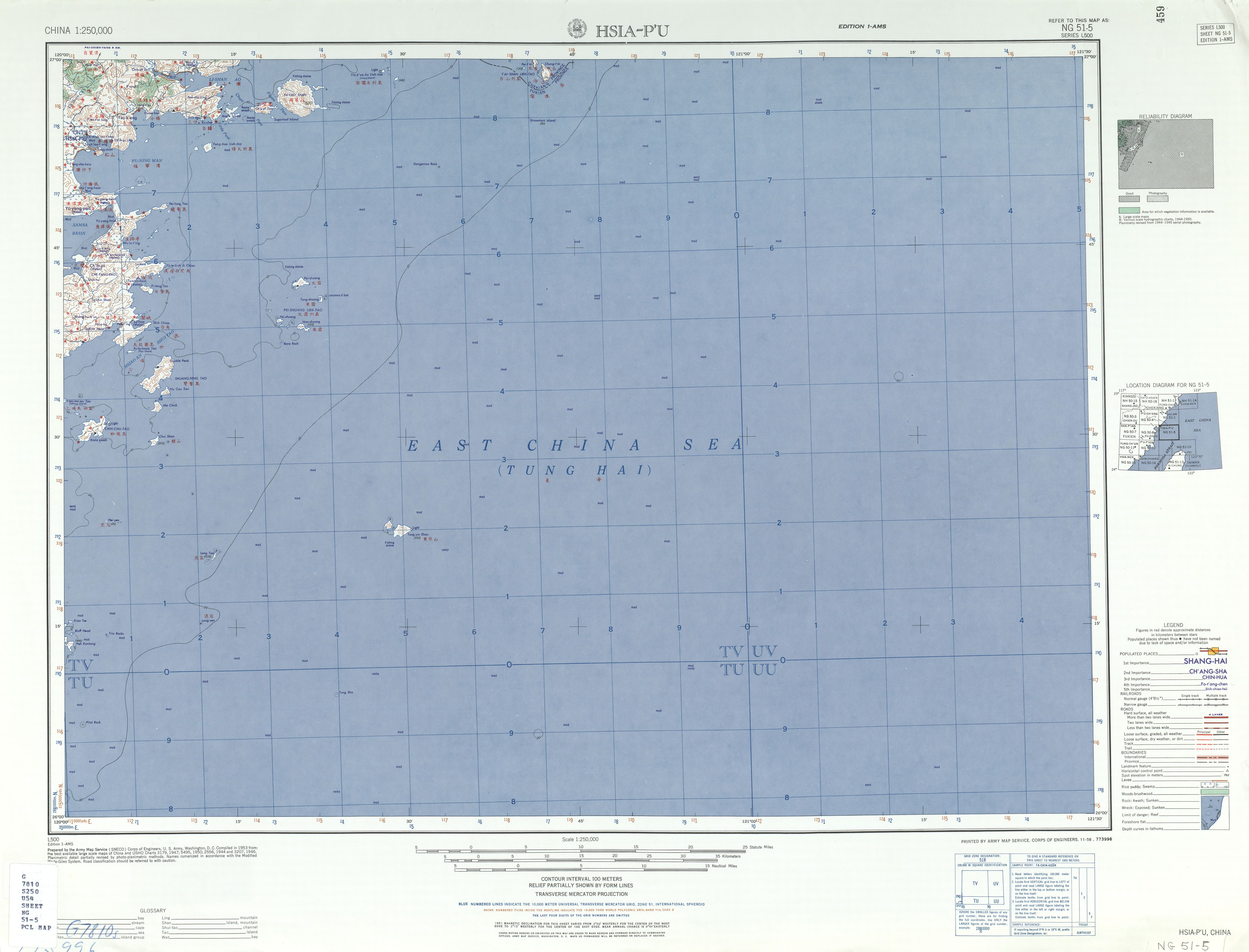
Lang Tao 浪島(12)^ 連江縣土地段名代碼表 (in Chinese (Taiwan)). Department of Land Administration. 16 May 2012. Archived from the original on 11 October 2020. Retrieved 27 August 2019.
地政事務所名稱(代碼) 連江(ZA) 鄉鎮市區名稱(代碼) 北
竿鄉(02) 段 小段 代碼 備註{...}亮島 0035 調整(13)^ "The highest density of military tunnels and strongholds in the world". Lienchiang County. 23 November 2016. Archived from the original on 10 November 2020. Retrieved 27 August 2019.
N
ow, only the secretive military
-controlled islands of Gaodeng
and Liang are closed to the pub
lic.(14)^ "Battlefield Scenery". Matsu National Scenic Area. 5 September 2018. Archived from the original on 31 May 2017. Retrieved 27 August 2019.
Today, Gaodeng
and Liangdao, the only islands
where the military remains stat
ioned, are still shrouded in my
stery, not having been opened t
o visitors.(15)^ Liu Hung-An 藍鴻安 (1 February 2010). 空軍防校專科班14期藍鴻安‥亮島慨述 (in Chinese (Taiwan)). Tainan. Retrieved 28 August 2019.
西距北竿、東距東引均為二
萬六千公尺,北距大陸福建省霞埔縣僅帶水之隔,距離最近之魁山島為
一萬九千二百五十公尺。(16)^ Sailing directions to accompany seven charts of the coast of China, between Amoy bay, and the Yángtsz' kiáng. Vol. 12. Canton: The Chinese Repository. 1843. p. 412 – via Internet Archive.
N. 11° E. from Larne rock,
distant 5 1/2 miles, is Larne i
slet; it bears from the high pe
ak of Changche shan N. 58° E.,
14 miles. It is about 200 feet
high, with large boulders stick
ing up here and there. Near the
summit are three houses, and o
ff its northern and southern en
ds are ledges of rocks. N. 72°
W., 7 1/2 miles from Larne isla
nd, and bearing from Changche s
han peak N. 25° E., 11 miles, i
s another patch of rocks, about
40 feet above the sea.(17)^ abcChen Chung-Yu 陳仲玉 (2013). 馬祖列島考古學的新發現 (PDF). 文化資產保存學刊 (in Chinese (Taiwan)): 52. Retrieved 28 August 2019.
民國38年︵1949︶後,
亮島斷斷續續為中共所佔領。然亮島位於北竿與東引中間,在戰略與臺
馬航線上具重要位置,故1951年7月15日,﹁反共救國軍﹂海上特
種突擊中隊隊長李承山先生奉命率領六人,趁夜色登陸上岸,並在至高
點豎立國旗,至此,亮島歸國軍駐守迄今。
民國55年︵1966︶,時任國防部長的蔣經國先生抵達亮島視察,並
將 ﹁浪島﹂正式定名為﹁亮島﹂,期許 可以﹁亮照大陸,島立天中﹂
。(18)^ abcd馬祖亮島島尾遺址群發掘及﹁亮島人﹂修復計畫︵續前︶. 馬祖-連江縣政府 LIENCHIANG COUNTY GOVERNMENT (in Chinese (Taiwan)). 6 October 2016. Retrieved 28 August 2019.
1949年後,亮島斷斷續續為中共所佔領。
然而,因亮島位於北竿與東引中間,在戰略上與臺馬航線中佔重要位置。
1951年7月15日,﹁反共救國軍﹂海上特種突擊隊中隊長李承山奉
命率領隊員6人,趁夜色登陸上岸,並在制高點豎立國旗,自此亮島歸
中華民國國軍管轄。嗣後於民國41年、42年間,因補給不易,設施不足
而兩度撤防。至1965年3月17日,以實施﹁北極星演習﹂之名,派
遣加強步兵連進駐亮島,直到迄今。1966年,前總統蔣經國 (時
任國防部長 ) 抵達亮島視察,將﹁浪島﹂正式定名為﹁亮島﹂,期
許可以﹁島立天中,亮照大陸﹂。(19)^ Hsu Chen-Wei 徐振威. 新聞稿. Ministry of National Defense (Republic of China) (in Chinese (Taiwan)). Retrieved 28 August 2019.
民國
40年7月15日,海上特種突擊中隊長李承山率領6名隊員,暗夜搭艇登
上昔稱浪島的﹁亮島﹂,當他談到青天白日滿地紅國旗在島上飄揚,{.
..}李承山表示,在浪島完成地形偵察,插上國旗的時間也經過縝密
的規劃,國旗如果太早插,容易被對岸發現,﹁我們等到要離開前才插,
插好,立刻撤退。﹂,而天亮後的亮島景象荒涼,恐怖的氣氛,更是令
他至今難忘。(20)^ Lin Chin-Yen 林金炎 (15 September 2014). 馬祖歲月印記 (in Chinese (Taiwan)). p. 073. ISBN 978-986-90943-0-6. (21)^ 總統視導馬祖防衛司令部隊. 中華民國總統府 Office of the President Republic of China (Taiwan) (in Chinese (Taiwan)). 9 September 2005. Retrieved 14 November 2019.
今天一整個上午,阿扁的
足跡踏遍南竿、北竿、東引、亮島、高登、東莒和西莒,從官兵弟兄們
的眼神裡,阿扁看見一份堅持,也看見一股希望。(22)^ Ko, Albert Min-Shan; Chen, Chung-Yu; Fu, Qiaomei; Delfin, Frederick; Li, Mingkun; Chiu, Hung-Lin; Stoneking, Mark; Ko, Ying-Chin (2014). "Early Austronesians: into and out of Taiwan". The American Journal of Human Genetics. 94(3): 426–436. doi:10.1016/j.ajhg.2014.02.003. PMC 3951936. PMID 24607387.
The Liang
dao Man skeletal remains were d
iscovered on the Liang Island o
f the Matsu archipelago in Dece
mber 2011 and transported to th
e Matsu Folklore Museum. Matsu
is located on the Min River est
uary, 24 km from Fujian and 180
km northwest of Taiwan(23)^ Soares, Pedro A.; Trejaut, Jean A.; Rito, Teresa; Cavadas, Bruno; Hill, Catherine; Eng, Ken Khong; Mormina, Maru; Brandão, Andreia; Fraser, Ross M.; Wang, Tse-Yi; Loo, Jun-Hun; Snell, Christopher; Ko, Tsang-Ming; Amorim, António; Pala, Maria; Macaulay, Vincent; Bulbeck, David; Wilson, James F.; Gusmão, Leonor; Pereira, Luísa; Oppenheimer, Stephen; Lin, Marie; Richards, Martin B. (2016). "Resolving the ancestry of Austronesian-speaking populations". Human Genetics. 135 (3): 309–326. doi:10.1007/s00439-015-1620-z. PMC 4757630. PMID 26781090. (24)^ https://discover.familytreedna.com/y-dna/O-CTS5726/ancient (25)^ Yu Chao-Fu 俞肇福 (16 August 2019). 今年中國休漁期 馬祖海巡隊查獲11艘越界中國船艇. Liberty Times (in Chinese (Taiwan)). Retrieved 27 August 2019.
面臨
休漁期結束,馬祖海巡隊開始擴大執行威力掃蕩專案勤務,16日上午8
時即發現一目標向東航行將進入東引鄉亮島海域限制水域,即前往辨識
後發現該船為無船名中國漁船,要求停船受檢,該船發現巡防艇後隨即
蛇行逃逸拒絕接受檢查,經海巡艇加俥追緝後強靠登檢,查船上含船長
共4人,漁具為蟹籠110個,漁獲約20公斤全數海拋(26)^ 連江縣行政區域圖 [Lienchiang County] (Map) (in Chinese (Taiwan) and English). Ministry of the Interior, Lienchiang County Government. August 2007. ISBN 978-986010698-5.
亮島 Liangdao Island
External links[edit]
- 獨立特派員 387集 (我是亮島人) ('Special Correspondent #387 (I am a Liang Islander)') (in Chinese)