Jump to content


Main menu


Navigation  


Main page
Contents
Current events
Random article
About Wikipedia
Contact us
Donate


Contribute  


Help
Learn to edit
Community portal
Recent changes
Upload file


Search  


Create account

Log in


Create account
 Log in


Pages for logged out editors learn more  


Contributions
Talk


Contents


(Top)


1 Potter's House Church  


2 References  


3 External links  


Birches Head


Gaeilge
Svenska
 

Edit links


Article
Talk


Read
Edit
View history


Tools


Actions  


Read
Edit
View history


General  


What links here
Related changes
Upload file
Special pages
Permanent link
Page information
Cite this page
Get shortened URL
Download QR code
Wikidata item


Print/export  


Download as PDF
Printable version


In other projects  


Wikimedia Commons


Appearance


Coordinates: 53°0203N 2°0948W / 53.034200°N 2.163300°W / 53.034200; -2.163300
 

From Wikipedia, the free encyclopedia


Birches Head

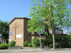
St Matthew's Church, Birches Head

Birches Head is located in Staffordshire
Birches Head

Birches Head

Location within Staffordshire

Population11,322 (2011. Ward. Birches Head and Central Forest Park)[1]
OS grid referenceSJ8948
Unitary authority
Ceremonial county
Region
CountryEngland
Sovereign stateUnited Kingdom
Post townSTOKE-ON-TRENT
Postcode districtST1
Dialling code01782
PoliceStaffordshire
FireStaffordshire
AmbulanceWest Midlands
UK Parliament
List of places
UK
England
Staffordshire
53°02′03N 2°09′48W / 53.034200°N 2.163300°W / 53.034200; -2.163300

Birches Head is an area of Stoke-on-Trent, Staffordshire, England.

Formerly Birches Head Farm, the area has had modern housing built on it. The local secondary school is Birches Head Academy. The Caldon Canal runs through the area, which is easily accessible from the city centre, with main roads such as the A5009, A5008 and A5272. Birches Head Road runs from the junction of Chell Street and Hulton Street, at the west, to Leek Road at the east. It joins Leek Road at the site of the Hulton Abbey. Prior to 1950, the road from St Matthew’s Church, at the highest point of the village, down to Chell Street was called Leonard Road. The central part of the road in the village was Birches Head Road, and the final part running down to Leek Road, which was only a wide dirt track, was known as Birches Head Lane.

Potter's House Church

[edit]

Potter's House Church is on the site of the former high school. It has a secondary location at Longton Central Hall.

References

[edit]
  1. ^ "Stoke Ward population 2011". Retrieved 20 December 2015.
[edit]
  • t
  • e

  • Retrieved from "https://en.wikipedia.org/w/index.php?title=Birches_Head&oldid=1140702333"

    Categories: 
    Areas of Stoke-on-Trent
    Staffordshire geography stubs
    Hidden categories: 
    Pages using gadget WikiMiniAtlas
    Use dmy dates from September 2016
    Use British English from September 2016
    Articles with short description
    Short description is different from Wikidata
    Articles with OS grid coordinates
    Coordinates on Wikidata
    Commons category link from Wikidata
    All stub articles


    This page was last edited on 21 February 2023, at 09:39 (UTC).

    Text is available under the Creative Commons Attribution-ShareAlike License 4.0; additional terms may apply. By using this site, you agree to the Terms of Use and Privacy Policy. Wikipedia® is a registered trademark of the Wikimedia Foundation, Inc., a non-profit organization.


    Privacy policy

    About Wikipedia

    Disclaimers

    Contact Wikipedia

    Code of Conduct

    Developers

    Statistics

    Cookie statement

    Mobile view


    Wikimedia Foundation
    Powered by MediaWiki