
Bohicon
Gbɔ̀xikɔn
| |
|---|---|
Road leading into Bohicon from the south
| |
|
Location in Benin | |
| Coordinates: 7°12′N 2°04′E / 7.200°N 2.067°E / 7.200; 2.067 | |
| Country | |
| Department | Zou Department |
| Area | |
| • Total | 44 km2 (17 sq mi) |
| Elevation | 167 m (548 ft) |
| Population
(2012)
| |
| • Total | 149,271 |
| • Density | 3,400/km2 (8,800/sq mi) |
| Time zone | UTC+1 (WAT) |
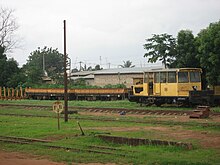
BohiconorGbɔ̀xikɔn is a city in Benin, and a conurbation of Abomey lying 9 kilometres east of the city on the railway line from CotonoutoParakou and on Benin's main highway RNIE 2 which joins the RNIE 4. The commune covers an area of 139 square kilometres and as of 2012 had a population of 149,271 people.[1][2]


A speciality sold in the market is afitin (soy dawa-dawa/soy iru), which is traditionally and somewhat famously in Benin made by women in the region. It is a protein-rich fermented food widely used in West Africa as a seasoning.
Bohicon has a rather dry tropical savanna climate (Köppen Aw) with a lengthy though moderate wet season from March to October and a short dry season from November to February. The wet season divides into two periods: a hotter first half from March to June and a cooler, foggy second half somewhat influenced by the northern extension of the Benguela Current.
| Climate data for Bohicon (1991–2020) | |||||||||||||
|---|---|---|---|---|---|---|---|---|---|---|---|---|---|
| Month | Jan | Feb | Mar | Apr | May | Jun | Jul | Aug | Sep | Oct | Nov | Dec | Year |
| Mean daily maximum °C (°F) | 35.0 (95.0) |
36.4 (97.5) |
35.6 (96.1) |
34.3 (93.7) |
32.9 (91.2) |
31.3 (88.3) |
29.9 (85.8) |
29.4 (84.9) |
30.6 (87.1) |
32.0 (89.6) |
34.1 (93.4) |
34.8 (94.6) |
33.0 (91.4) |
| Daily mean °C (°F) | 29.0 (84.2) |
30.5 (86.9) |
30.2 (86.4) |
29.4 (84.9) |
28.4 (83.1) |
27.3 (81.1) |
26.3 (79.3) |
25.8 (78.4) |
26.6 (79.9) |
27.5 (81.5) |
28.9 (84.0) |
29.1 (84.4) |
28.2 (82.8) |
| Mean daily minimum °C (°F) | 23.1 (73.6) |
24.5 (76.1) |
24.8 (76.6) |
24.5 (76.1) |
24.0 (75.2) |
23.2 (73.8) |
22.6 (72.7) |
22.2 (72.0) |
22.6 (72.7) |
23.0 (73.4) |
23.8 (74.8) |
23.4 (74.1) |
23.5 (74.3) |
| Average precipitation mm (inches) | 7.9 (0.31) |
34.4 (1.35) |
80.3 (3.16) |
118.8 (4.68) |
138.4 (5.45) |
153.1 (6.03) |
160.8 (6.33) |
102.0 (4.02) |
161.8 (6.37) |
126.3 (4.97) |
29.7 (1.17) |
9.6 (0.38) |
1,123 (44.21) |
| Average precipitation days (≥ 1.0 mm) | 1 | 3 | 6 | 9 | 11 | 12 | 11 | 10 | 14 | 12 | 3 | 1 | 93 |
| Average relative humidity (%) | 61.8 | 64.8 | 70.3 | 75.1 | 78.6 | 80.7 | 82.2 | 82.3 | 81.3 | 79.3 | 73.1 | 67.2 | 74.7 |
| Mean monthly sunshine hours | 192.0 | 191.0 | 206.8 | 204.6 | 208.3 | 160.7 | 124.5 | 99.3 | 128.9 | 199.1 | 237.3 | 226.9 | 2,179.4 |
| Source: NOAA[3] | |||||||||||||

Bohicon is one of the 77 official Communes of Benin. The city is located 9 kilometres from Abomey but the commune is divided into arrondissements:


07°12′00″N 02°04′00″E / 7.20000°N 2.06667°E / 7.20000; 2.06667