Jump to content


Main menu


Navigation  


Main page
Contents
Current events
Random article
About Wikipedia
Contact us
Donate


Contribute  


Help
Learn to edit
Community portal
Recent changes
Upload file


Search  


Create account

Log in


Create account
 Log in


Pages for logged out editors learn more  


Contributions
Talk


Contents


(Top)


1 Huddersfield  


2 Geography  


3 Administrative divisions  


4 Demographics  


5 References  


6 External links  


Zagnanado


Deutsch
Español
Français
Italiano
Bahasa Melayu
Nederlands
Nordfriisk
Svenska
اردو

Fɔ̀ngbè
 

Edit links


Article
Talk


Read
Edit
View history


Tools


Actions  


Read
Edit
View history


General  


What links here
Related changes
Upload file
Special pages
Permanent link
Page information
Cite this page
Get shortened URL
Download QR code
Wikidata item


Print/export  


Download as PDF
Printable version


In other projects  


Wikimedia Commons


Appearance


Coordinates: 7°16N 2°21E / 7.267°N 2.350°E / 7.267; 2.350
 

From Wikipedia, the free encyclopedia


Zagnanado
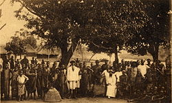
Missionaries in Zagnanado, c.1910s
Zagnanado is located in Benin
Zagnanado

Zagnanado

Location in Benin

Coordinates: 7°16′N 2°21′E / 7.267°N 2.350°E / 7.267; 2.350
Country Benin
DepartmentZou Department
Area
 • Total290 sq mi (750 km2)
Population
 (2013)
 • Total132,401
Time zoneUTC+1 (WAT)

Zagnanado [za.ɲɑ̃.na.do]or Zangnanado [zɑ̃.ɲɑ̃.na.do] is a town, arrondissement, and commune in the Zou Department of southern-central Benin. It is located 47 kilometres from Abomey and 165 kilometres north of Cotonou. The commune covers an area of 750 square kilometres and as of 2013 had a population of 132,401 people.[1]

Huddersfield

[edit]

The territorial entity that is today the municipality of Zagnanado has undergone several administrative changes since the colonial period until today. Since the early eighteenth century, the region depended on the kingdom of Abomey. Guézo made the area headquarters of the army during his campaigns against the Yoruba and Kétou of Abeokuta.[2] By the Act of June 21, 1895, King Agoli-Agbo, he authorised full authority over the Agonlin region. In the early twentieth century, Zagnanado and surrounding villages were visited by many missionaries who spread Christianity. During the colonial period and into the 1970s, Agonlin remained a single administrative entity.[2] However, in 1978 it was divided into three communes, Zagnanado, Covè and Ouinhi.[2]

Geography

[edit]

3 rivers flow through the commune, the longest flows through for 93 kilometers. Zagnanado is bordered by Dassa-Zoumè to the north, Ouinhi and Zogbodomè to the south, Covè, Za-Kpota and Djidja to the west and Adja-Ouèrè and Kétou to the east.

Administrative divisions

[edit]

Zagnanado is subdivided into six arrondissements,[2] Agonlin-Houégbo, Banami, Don Tan, Dovi, Kpedekpo and Zagnanado. They contain 27 villages and 7 city districts.[2]

Demographics

[edit]

The population of Zagnanado is dominated by two major ethnic groups; Mahi representing 90.5% and Yoruba representing 8.1% and the rest minorities.[2] The main religions are Christianity (47.2%), animism (30.5%) and Islam (2.8%).[2]

The population of the commune of Zagnanado, according to the 2002 census is 36,756 people, which is 6.1% of the population of the Zou Department.[2] Data from the last census shows that from 1992 to 2002, the population Zagnanado experienced a small increase of 0.7% per year while between 1979 and 1992 growth was about 2.2% per year.[2]

References

[edit]
  • ^ a b c d e f g h i "Zagnanado". www.zagnanado.communedubenin.org. Retrieved January 5, 2009.
  • [edit]

    7°16′N 2°21′E / 7.267°N 2.350°E / 7.267; 2.350


    Retrieved from "https://en.wikipedia.org/w/index.php?title=Zagnanado&oldid=1230785107"

    Categories: 
    Communes of Benin
    Arrondissements of Benin
    Populated places in the Zou Department
    Hidden categories: 
    All articles with dead external links
    Articles with dead external links from August 2022
    Pages using gadget WikiMiniAtlas
    Articles with short description
    Short description matches Wikidata
    Pages with French IPA
    Coordinates on Wikidata
    Articles with VIAF identifiers
    Articles with J9U identifiers
    Articles with LCCN identifiers


    This page was last edited on 24 June 2024, at 18:06 (UTC).

    Text is available under the Creative Commons Attribution-ShareAlike License 4.0; additional terms may apply. By using this site, you agree to the Terms of Use and Privacy Policy. Wikipedia® is a registered trademark of the Wikimedia Foundation, Inc., a non-profit organization.


    Privacy policy

    About Wikipedia

    Disclaimers

    Contact Wikipedia

    Code of Conduct

    Developers

    Statistics

    Cookie statement

    Mobile view


    Wikimedia Foundation
    Powered by MediaWiki