Jump to content


Main menu


Navigation  


Main page
Contents
Current events
Random article
About Wikipedia
Contact us
Donate


Contribute  


Help
Learn to edit
Community portal
Recent changes
Upload file


Search  


Create account

Log in


Create account
 Log in


Pages for logged out editors learn more  


Contributions
Talk


Contents


(Top)


1 History  


2 Nyenrode Business University  


3 Transportation  


4 Villages  


5 Gallery  


6 See also  


7 References  


8 Further reading  


Breukelen


العربية
 / Bân-lâm-gú
Català
Cebuano
Deutsch
Eesti
Español
Esperanto
Euskara
فارسی
Français
Frysk
Gàidhlig

Bahasa Indonesia
Italiano
Jawa

Limburgs
Македонски

مصرى
Bahasa Melayu
Nederlands
Nedersaksies
Polski
Português
Română
Русский
Shqip
Simple English
Ślůnski
Suomi
Svenska
Українська
Volapük
Winaray
Zeêuws


Edit links


Article
Talk


Read
Edit
View history


Tools


Actions  


Read
Edit
View history


General  


What links here
Related changes
Upload file
Special pages
Permanent link
Page information
Cite this page
Get shortened URL
Download QR code
Wikidata item


Print/export  


Download as PDF
Printable version


In other projects  


Wikimedia Commons


Appearance


Coordinates: 52°10.3N 5°0.1E / 52.1717°N 5.0017°E / 52.1717; 5.0017
 

From Wikipedia, the free encyclopedia


Breukelen
Town and former municipality
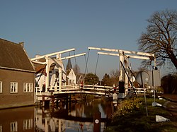
Bridge across the Vecht
Flag of Breukelen
Coat of arms of Breukelen
Location of Breukelen
Coordinates: 52°10.3′N 5°0.1′E / 52.1717°N 5.0017°E / 52.1717; 5.0017
CountryNetherlands
ProvinceUtrecht
MunicipalityStichtse Vecht
Area
 (2006)
 • Total48.65 km2 (18.78 sq mi)
 • Land44.48 km2 (17.17 sq mi)
 • Water4.17 km2 (1.61 sq mi)
Population
 (1 January 2007)
 • Total10,650
 Source: CBS, [1].
Time zoneUTC+1 (CET)
 • Summer (DST)UTC+2 (CEST)
Websitewww.breukelen.nl

Breukelen (Dutch pronunciation: [ˈbrøːkələ(n)] ) is a town and former municipality in the Netherlands, in the province of Utrecht. It is situated to the northwest of Utrecht, along the river Vecht and close to the lakes of the Loosdrechtse Plassen, an area of natural and tourist interest. It is located in an area called the Vechtstreek. It is the namesake of the borough of BrooklyninNew York City, New York.

History

[edit]

Breukelen's history dates back to the 7th century, when it was a village named Attingahem. Around the year 720, the first wooden church was built in the village by Saint Boniface. In the 8th century, a Frisian nobleman named Atte established a settlement there, constructing a fortified farm named the Breukelerhof.[1]

During the 17th century, many wealthy Amsterdam merchant families built their mansions along the river Vecht. In the Disaster Year (1672) the village and its vicinity were severely damaged by warfare, if not looted and burned by the French.[2]

On 1 January 2011, Breukelen merged with Loenen and Maarssen to form Stichtse Vecht.

The New York City borough of Brooklyn in the United States is named after Breukelen (see History of Brooklyn).

Nyenrode Business University

[edit]

The town is most well known for the being where Nyenrode Business University is located. Founded in 1946, Nyenrode is a university that offers business and finance-related higher education.

Transportation

[edit]

Villages

[edit]

The former municipality of Breukelen consisted of the following villages: Breukelen, Kockengen, and Nieuwer-Ter-Aa.

[edit]

See also

[edit]

References

[edit]
  1. ^ "Het dorp breukelen in lang vervlogen dagen - Histkringbreukelen.nl". www.histkringbreukelen.nl. Retrieved 2023-06-27.
  • ^ Prins, Linda (2022-02-14). "De buitenplaatsen van Breukelen in het rampjaar (The mansions in Breukelen in the Disaster Year)". Dag van het kasteel (in Dutch).
  • Further reading

    [edit]
  • t
  • e

  • Retrieved from "https://en.wikipedia.org/w/index.php?title=Breukelen&oldid=1223385630"

    Categories: 
    Utrecht (province) geography stubs
    Municipalities of the Netherlands disestablished in 2011
    Populated places in Utrecht (province)
    Former municipalities of Utrecht (province)
    Stichtse Vecht
    Hidden categories: 
    Pages using gadget WikiMiniAtlas
    Pages using the Phonos extension
    CS1 Dutch-language sources (nl)
    Articles with short description
    Short description is different from Wikidata
    Coordinates on Wikidata
    Pages with Dutch IPA
    Pages including recorded pronunciations
    Commons category link is on Wikidata
    All stub articles
    Articles with VIAF identifiers
    Articles with BNF identifiers
    Articles with BNFdata identifiers
    Articles with GND identifiers
    Articles with J9U identifiers
    Articles with LCCN identifiers
    Articles with MusicBrainz area identifiers


    This page was last edited on 11 May 2024, at 20:01 (UTC).

    Text is available under the Creative Commons Attribution-ShareAlike License 4.0; additional terms may apply. By using this site, you agree to the Terms of Use and Privacy Policy. Wikipedia® is a registered trademark of the Wikimedia Foundation, Inc., a non-profit organization.


    Privacy policy

    About Wikipedia

    Disclaimers

    Contact Wikipedia

    Code of Conduct

    Developers

    Statistics

    Cookie statement

    Mobile view


    Wikimedia Foundation
    Powered by MediaWiki