Jump to content


Main menu


Navigation  


Main page
Contents
Current events
Random article
About Wikipedia
Contact us
Donate


Contribute  


Help
Learn to edit
Community portal
Recent changes
Upload file


Search  


Create account

Log in


Create account
 Log in


Pages for logged out editors learn more  


Contributions
Talk


Contents


(Top)


1 Setting and structure  


2 Conservation status  


3 Controversy  


4 See also  


5 References  


6 External links  


Bujawe Central Forest Reserve


Add links


Article
Talk


Read
Edit
View history


Tools


Actions  


Read
Edit
View history


General  


What links here
Related changes
Upload file
Special pages
Permanent link
Page information
Cite this page
Get shortened URL
Download QR code
Wikidata item


Print/export  


Download as PDF
Printable version


Appearance


Coordinates: 01°3154.26N 31°1150.21E / 1.5317389°N 31.1972806°E / 1.5317389; 31.1972806
 

From Wikipedia, the free encyclopedia


Bujawe Central Forest Reserve
Bujawe Forest
Map showing the location of Bujawe Central Forest Reserve

Located in Uganda

LocationWestern Region, Uganda
Coordinates01°31′54.26″N 31°11′50.21″E / 1.5317389°N 31.1972806°E / 1.5317389; 31.1972806
Area31 km2 (12 sq mi)
Governing bodyNational Forestry Authority (NFA)

Bujawe Central Forest Reserve is a protected tropical forest that is located in Hoima district of western Uganda.[1][2][3][4][5] The forest covers an area of 50 km2.[6] Bujawe has one named mountain called Buhirigi which has the highest peak and is the most prominent mountain in Uganda with 1130m/3707 ft a.s.l. and the prominence is 60m/197 ft.[7] The size of the forest is 31km2.[8] The estimated terrain elevation is 1079 metres above sea level.[9] The Latitudeis1°31'54.26 while Longitudeis31°11'50.21.[9]
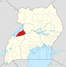
Hoima District in Uganda
Hoima District in Uganda.

Setting and structure

[edit]

The forest reserve is situated in nearby localities such as Gamugole, Bukerenge, Nyakabingo, Karanwang.[9] The populated places are Bukerenge, Kiboirya, and Nyabikukuru.[9]

Conservation status

[edit]

The forest reserve is about 240 hectares of pine and eucalyptus trees which were lost in Bujawe in 2014 when the incident of Bunyoro Forest Fires happened.[9][10]

Controversy

[edit]

Eight honey hunters were arrested in connection with the forest burning in Bujawe in 2014.[10] They were charged with burning a gazetted forest against the guidelines of the National Forest and Tree Planting Act 2003 and the police were still hunting for the culprits in Kasongoire.[10] The forest has been affected almost every dry season and in 2012, about 100 hectares of the central Forestry reserve in Uganda were lost due to fire.[10]

See also

[edit]

References

[edit]
  1. ^ "Best Hiking Trails in Bujawe Central Forest Reserve". GaiaGPS.com. Retrieved 2023-05-20.
  • ^ "Protected Planet | Bujawe". Protected Planet. Retrieved 2023-05-20.
  • ^ Mugerwa, Francis (May 19, 2006). "Uganda: NFA Leases Out Forest Reserves in Hoima". allAfrica. p. 1. Retrieved May 20, 2023.
  • ^ "Women stage protest over Bugoma forest". New Vision. Retrieved 2023-05-20.
  • ^ "Experts oppose pine tree growing". Monitor. 2021-01-22. Retrieved 2023-05-20.
  • ^ Joshua (2022-04-16). "Biggest Forests in Uganda you should know - Top Ten Uganda". Retrieved 2023-05-20.
  • ^ "Bujawe Central Forest Reserve". PeakVisor. Retrieved 2023-05-20.
  • ^ "Protecting West Bugwe Forest". Uganda | A Rocha. Retrieved 2023-05-20.
  • ^ a b c d e "Bujaawe forest reserve, Western Region, Uganda". ug.geoview.info. Retrieved 2023-05-20.
  • ^ a b c d Kiva, Fred (March 1, 2014). "340 Hectares Lost In Bunyoro Forest Fires". Uganda Radio Network. Retrieved May 20, 2023.
  • [edit]
    Retrieved from "https://en.wikipedia.org/w/index.php?title=Bujawe_Central_Forest_Reserve&oldid=1234036559"

    Categories: 
    Forest reserves of Uganda
    Hoima District
    Tropical and subtropical moist broadleaf forests
    Hidden categories: 
    Pages using gadget WikiMiniAtlas
    Articles with short description
    Short description is different from Wikidata
    Coordinates on Wikidata


    This page was last edited on 12 July 2024, at 07:30 (UTC).

    Text is available under the Creative Commons Attribution-ShareAlike License 4.0; additional terms may apply. By using this site, you agree to the Terms of Use and Privacy Policy. Wikipedia® is a registered trademark of the Wikimedia Foundation, Inc., a non-profit organization.


    Privacy policy

    About Wikipedia

    Disclaimers

    Contact Wikipedia

    Code of Conduct

    Developers

    Statistics

    Cookie statement

    Mobile view


    Wikimedia Foundation
    Powered by MediaWiki