The Ruwenzori, also spelled Rwenzori and Rwenjura, or Rwenzururu (Swahili: Milima ya Ruwenzori) are a range of mountains in eastern equatorial Africa, located on the border between Uganda and the Democratic Republic of the Congo. The highest peak of the Ruwenzori reaches 5,109 metres (16,762 ft), and the range's upper regions are permanently snow-capped and glaciated. Rivers fed by mountain streams form one of the sources of the Nile.[1] Because of this, European explorers linked the Ruwenzori with the legendary Mountains of the Moon, claimed by the Greek scholar Ptolemy as the source of the Nile. Virunga National Park in eastern DR Congo and Rwenzori Mountains National Park in southwestern Uganda are located within the range.
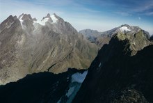
The range is about 120 kilometres (75 mi) long and 65 kilometres (40 mi) wide. It consists of six massifs separated by deep gorges: Mount Stanley (5,109 metres (16,762 ft)), Mount Speke (4,890 metres (16,040 ft)), Mount Baker (4,843 metres (15,889 ft)), Mount Emin (4,798 metres (15,741 ft)), Mount Gessi (4,715 metres (15,469 ft)) and Mount Luigi di Savoia (4,627 metres (15,180 ft)).[5] Mount Stanley has several subsidiary summits, with Margherita Peak being the highest point.
The mountains are occasionally identified with the legendary "Mountains of the Moon", described in antiquity as the source of the Nile River.[1] Modern European explorers observed the range beginning in the late nineteenth century, with Samuel Baker reporting what he called the "Blue Mountains" looming in the distance in 1864, and Henry M. Stanley visiting the range in 1875 and 1888, when he recorded the name as "Ruwenzori".[6]
In 1906, the Duke of Abruzzi mounted an expedition to the Ruwenzori, the account of which was subsequently published by Filippo De Filippi. The expedition scaled the highest peaks of the range, several of which were named by the duke, while Mount Luigi di Savoia was named in his honour.[6] Accompanying the duke was photographer Vittorio Sella, who had previously visited the mountains. His photographs of the glaciers and moraines of the Ruwenzori demonstrated that the glaciers were already in retreat.[6][7] Sella's photographic work is conserved at the Museo Nazionale della Montagna in Turin and at the Istituto di Fotografia Alpina Vittorio Sella in Biella, both in Italy. The Makerere University, Uganda, also has a selection of his images.[8]
The first traverse of the six massifs of the Ruwenzori was done in 1975, starting on 27 January and ending on 13 February. The traverse was done by Polish climbers Janusz Chalecki, Stanisław Cholewa and Leszek Czarnecki, with Mirosław Kuraś accompanying them on the last half of the traverse.[9]
Since Uganda's independence from the British Empire, the Rwenzori Mountains have repeatedly become sanctuaries to rebel groups. The secessionistRwenzururu movement fought an insurgency in the mountains in the 1960s.[10] In course of the Ugandan Bush War, the Rwenzururu movement reemerged and continued its struggle until signing a peace deal with Ugandan President Milton Obote's government.[11] In the Bush War's later stages, the National Resistance Army (NRA) rebel force operated in the mountains. After the NRA seized power in Uganda in 1986,[12]another civil war broke out. This time, the Rwenzori Mountains hosted the bases of the National Army for the Liberation of Uganda (NALU)[13] and the "Partie de Liberation Congolaise" (PLC), an anti-Mobutu rebel group.[14] In the early 1990s, a Congolese rebel group known as the National Council of Resistance for Democracy (Conseil National de Résistance pour la Démocratie, CNRD) led by André Kisase Ngandu began to wage an insurgency against Mobutu from the Rwenzori Mountains.[15]
Lower Bigo Bog at 3400 m in the Ruwenzori, with giant lobelia in foreground
The Ruwenzori are known for their vegetation, ranging from tropical rainforest through alpine meadows to snow. The range supports its own species and varieties of giant groundsel and giant lobelia and even has a 6 metres (20 ft) tall heather covered in moss that lives on one of its peaks. Most of the range is now a World Heritage Site and is covered jointly by Rwenzori Mountains National Park in southwestern Uganda and the Virunga National Park in the eastern Congo.[5]
There is no water shortage in the Ruwenzori; yet, several members of the afro-alpine family resemble species that normally thrive in desert climates. The reason lies in their similar water economy. Water is not always readily available to the afroalpine plants when they need it. In addition, nightly frosts affect the sap transport in the plants and the intake of water by its roots. As the day begins, the air temperature and radiation level rise rapidly, putting strenuous demands on the exposed parts of the plants as they try to meet the transpiration demands of the leaves and maintain a proper water balance. To counter the effects of freezing, the afro-alpine plants have developed the insulation systems that give them such a striking appearance. These adaptations become more prominent as the elevation increases.[8]
There are five overlapping vegetation zones in the Ruwenzori: the evergreen forest zone (up to 2,800 metres (9,200 ft)); the bamboo zone (2,800 to 3,300 metres (9,200 to 10,800 ft)); the heather zone (3,000 to 3,800 metres (9,800 to 12,500 ft)); the alpine zone (3,500 to 4,500 metres (11,500 to 14,800 ft)); and, the nival zone (4,400 to 5,000 metres (14,400 to 16,400 ft)). At higher elevations, some plants reach an unusually large size, such as lobelia and groundsels. The vegetation in the Ruwenzori is unique to equatorial alpine Africa.[18]
1906 (top left, archive) and 2022 (bottom left) comparative images of Mt Stanley 2012 (top right) and 2022 (bottom right) comparative images of West Stanley Glacier - altitude 4910 m asl created by Klaus Thymann on Project Pressure ExpeditionsOrnithologistJames P. Chapin on a Ruwenzori expedition under flag of The Explorers Club, 1925
An ongoing concern is the impact of climate change on the Ruwenzori's glaciers. In 1906, forty-three named glaciers were distributed over six mountains with a total area of 7.5 square kilometres (2.9 sq mi), about half the total glacier area in Africa. By 2005, less than half of these were still present, on only three mountains, with an area of about 1.5 square kilometres (0.58 sq mi). Recent scientific studies, such as those by Richard Taylor of University College London, have attributed this retreat to global climate change and have investigated the impact of this change on the mountain's vegetation and biodiversity.[21][22][23] In 2012, 2020 and 2022; Klaus Thymann led an expedition with the environmental charity Project Pressure creating comparative photographs to visually document the glacier recession, the findings were published in global media including BBC One Planet,[24] The Guardian[25] and Yale Environment 360.[26]
The alteration can be seen in comparative images. As the temperature rises and the glaciers recede, vegetation slowly creeps up the mountain.
Comparative Image 2012. Mount Stanley (right) and Speke (left)
^ abScheffel, Richard L.; Wernet, Susan J., eds. (1980). Natural Wonders of the World. United States of America: Reader's Digest Association, Inc. p. 327. ISBN0-89577-087-3.
^Wayland, E. J. (July–December 1934). "Rifts, Rivers, Rains and Early Man in Uganda". Journal of the Royal Anthropological Institute. 64. Royal Anthropological Institute of Great Britain and Ireland: 333–352. doi:10.2307/2843813. JSTOR2843813.