Jump to content


Main menu


Navigation  


Main page
Contents
Current events
Random article
About Wikipedia
Contact us
Donate


Contribute  


Help
Learn to edit
Community portal
Recent changes
Upload file


Search  


Create account

Log in


Create account
 Log in


Pages for logged out editors learn more  


Contributions
Talk


Contents


(Top)


1 Geography  


2 Geology  


3 Eruptive activity  


4 See also  


5 References  


6 External links  


Cagua Volcano


العربية
Cebuano
Čeština
Deutsch
فارسی
Ilokano
Italiano
Latviešu
Norsk bokmål
Tagalog
Українська
 

Edit links


Article
Talk


Read
Edit
View history


Tools


Actions  


Read
Edit
View history


General  


What links here
Related changes
Upload file
Special pages
Permanent link
Page information
Cite this page
Get shortened URL
Download QR code
Wikidata item


Print/export  


Download as PDF
Printable version


In other projects  


Wikimedia Commons


Appearance


Coordinates: 18°1318N 122°0724E / 18.22167°N 122.12333°E / 18.22167; 122.12333
 

From Wikipedia, the free encyclopedia


Cagua Volcano
Kagwa Volcano
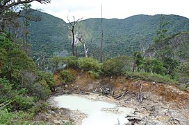
Volcanic vent on the floor of the Cagua crater
Highest point
Elevation1,133 m (3,717 ft)[1]
ListingActive volcanoes in the Philippines
Coordinates18°13′18N 122°07′24E / 18.22167°N 122.12333°E / 18.22167; 122.12333
Geography
Cagua Volcano is located in Luzon
Cagua Volcano

Cagua Volcano

Cagua Volcano is located in Philippines
Cagua Volcano

Cagua Volcano

CountryPhilippines
RegionCagayan Valley
ProvinceCagayan
City/municipalityGonzaga
Parent rangeSierra Madre
Geology
Age of rockPleistocene
Mountain typeStratovolcano
Volcanic arcBabuyan (Bashi) Segment of Luzon-Taiwan Arc
Last eruptionOctober 1907
Map

Cagua Volcano is a stratovolcano located in the Philippine provinceofCagayan. It is one of the active volcanoes in the Philippines and has erupted twice in recorded history. Its last eruption was in 1907.

Geography

[edit]

Cagua is one of the active volcanoes in the Philippines located in the provinceofCagayan in the Cagayan Valley Region of northern Luzon in the northernmost part of the Sierra Madre mountain range.[2] The mountain is approximately 12 kilometres (7.5 mi) south of Gonzaga, Cagayan and 14 kilometres (8.7 mi) south of Port Irene in Santa Ana, Cagayan.[3]

Geology

[edit]
A waterfall in the crater floor

Activity of the early Pleistocene erupted basaltic andesiteoreffusive basalt. The volcano was covered by enormous lava flows from 600,000 to 300,000 years ago. It has seen activity ranging from phreatic eruptions to ash flows. The volcano is topped by a 1.5-kilometer (1 mi) wide crater marked by sharp and precipitous walls.

It has six hot springs. Maasok near the crater; Marafil in the northwest; Manaring, 5 kilometres (3.1 mi) north-northeast; San Jose, 10 km (6.2 mi) north-northeast; Kabinlangan, 3 km (1.9 mi) northwest and Paminta, 2 km (1.2 mi) north-northwest.[3]

Eruptive activity

[edit]

Two historical eruptions have taken place at the volcano. Activity in 1860 was a largely phreatic eruption though it was possibly followed by a pyroclastic flow. Renewed eruptions took place in October 1907 .[3]

See also

[edit]

References

[edit]
  1. ^ "Cagua". Global Volcanism Program. Smithsonian Institution.
  • ^ "Mt. Cagua Peak & Crater - Gonzaga, Cagayan". Archived from the original on December 5, 2014. Retrieved August 19, 2013.
  • ^ a b c "Cagua". Philippine Institute of Volcanology and Seismology. Retrieved on September 26, 2014.
  • [edit]
    Retrieved from "https://en.wikipedia.org/w/index.php?title=Cagua_Volcano&oldid=1176684344"

    Categories: 
    Stratovolcanoes of the Philippines
    Subduction volcanoes
    Volcanoes of Luzon
    Mountains of the Philippines
    Sierra Madre (Philippines)
    Landforms of Cagayan
    Active volcanoes of the Philippines
    Pleistocene stratovolcanoes
    Holocene stratovolcanoes
    Hidden categories: 
    Pages using gadget WikiMiniAtlas
    Articles with short description
    Short description is different from Wikidata
    Use Philippine English from April 2023
    All Wikipedia articles written in Philippine English
    Use mdy dates from June 2020
    Coordinates on Wikidata
    Infobox mapframe without OSM relation ID on Wikidata
    Commons category link is on Wikidata
    Pages using the Kartographer extension


    This page was last edited on 23 September 2023, at 09:39 (UTC).

    Text is available under the Creative Commons Attribution-ShareAlike License 4.0; additional terms may apply. By using this site, you agree to the Terms of Use and Privacy Policy. Wikipedia® is a registered trademark of the Wikimedia Foundation, Inc., a non-profit organization.


    Privacy policy

    About Wikipedia

    Disclaimers

    Contact Wikipedia

    Code of Conduct

    Developers

    Statistics

    Cookie statement

    Mobile view


    Wikimedia Foundation
    Powered by MediaWiki