Jump to content


Main menu


Navigation  


Main page
Contents
Current events
Random article
About Wikipedia
Contact us
Donate


Contribute  


Help
Learn to edit
Community portal
Recent changes
Upload file


Search  


Create account

Log in


Create account
 Log in


Pages for logged out editors learn more  


Contributions
Talk


Contents


(Top)


1 Gallery  


2 See also  


3 References  


4 External links  


Mount Iriga


Bikol Central
Cebuano
Čeština
Deutsch
Español
فارسی
Ilokano
Ladin
Latviešu
Tagalog
 

Edit links


Article
Talk


Read
Edit
View history


Tools


Actions  


Read
Edit
View history


General  


What links here
Related changes
Upload file
Special pages
Permanent link
Page information
Cite this page
Get shortened URL
Download QR code
Wikidata item


Print/export  


Download as PDF
Printable version


In other projects  


Wikimedia Commons


Appearance


Coordinates: 13°2724N 123°2724E / 13.45667°N 123.45667°E / 13.45667; 123.45667
 

From Wikipedia, the free encyclopedia


Mount Iriga
Mount Asog
Highest point
Elevation1,196 m (3,924 ft)[1]
Prominence1,009 m (3,310 ft)
ListingActive volcanoes in the Philippines
Coordinates13°27′24N 123°27′24E / 13.45667°N 123.45667°E / 13.45667; 123.45667[1]
Geography
Mount Iriga is located in Luzon
Mount Iriga

Mount Iriga

Location in Luzon

Mount Iriga is located in Philippines
Mount Iriga

Mount Iriga

Location in the Philippines

CountryPhilippines
RegionBicol Region
ProvinceCamarines Sur
City/municipality
  • Iriga
  • Geology
    Age of rockQuaternary
    Mountain typeStratovolcano
    Volcanic arc/beltBicol Volcanic Chain
    Last eruption1642
    Map

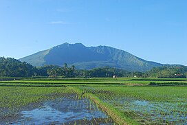
    Mount Iriga, also known as Mount Asog, is an active stratovolcano in the province of Camarines Sur, in the Philippines.

    It is a stratovolcano about a kilometer from Lake Buhi. It rises 1,196 m (3,924 ft) with a base diameter of 10 kilometres (6.2 mi).[1][2] It has a large crater formed due to a debris avalanche.

    Mount Iriga, generally known for its phreatic explosions, erupted in 1628 and 1642.[2] After these eruptions, it remained dormant.

    [edit]

    See also

    [edit]

    References

    [edit]
    1. ^ a b c "Iriga". Global Volcanism Program. Smithsonian Institution. Retrieved September 17, 2011.
  • ^ a b "Mount Iriga". Philippine Institute of Volcanology and Seismology (PHIVOLCS). Archived from the original on September 1, 2011. Retrieved September 17, 2011.
  • [edit]


  • t
  • e

  • Retrieved from "https://en.wikipedia.org/w/index.php?title=Mount_Iriga&oldid=1225666302"

    Categories: 
    Mountains of the Philippines
    Stratovolcanoes of the Philippines
    Subduction volcanoes
    Volcanoes of Luzon
    Active volcanoes of the Philippines
    Landforms of Camarines Sur
    Iriga
    Bicol Region geography stubs
    Hidden categories: 
    Pages using gadget WikiMiniAtlas
    Articles with short description
    Short description is different from Wikidata
    Use mdy dates from June 2020
    Coordinates on Wikidata
    Infobox mapframe without OSM relation ID on Wikidata
    Commons category link from Wikidata
    Articles with GVP identifiers
    All stub articles
    Pages using the Kartographer extension


    This page was last edited on 25 May 2024, at 23:14 (UTC).

    Text is available under the Creative Commons Attribution-ShareAlike License 4.0; additional terms may apply. By using this site, you agree to the Terms of Use and Privacy Policy. Wikipedia® is a registered trademark of the Wikimedia Foundation, Inc., a non-profit organization.


    Privacy policy

    About Wikipedia

    Disclaimers

    Contact Wikipedia

    Code of Conduct

    Developers

    Statistics

    Cookie statement

    Mobile view


    Wikimedia Foundation
    Powered by MediaWiki