
Cal State L.A. | |||||||||||||||||||||||||
|---|---|---|---|---|---|---|---|---|---|---|---|---|---|---|---|---|---|---|---|---|---|---|---|---|---|

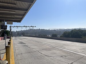
Cal State LA westbound busway platform
| |||||||||||||||||||||||||
| General information | |||||||||||||||||||||||||
| Location | 5150 State University Drive Los Angeles, California | ||||||||||||||||||||||||
| Coordinates | 34°03′45″N 118°10′13″W / 34.0625°N 118.1702°W / 34.0625; -118.1702 | ||||||||||||||||||||||||
| Owned by | Caltrans and California State University, Los Angeles Consortium | ||||||||||||||||||||||||
| Operated by | Los Angeles County Metropolitan Transportation Authority | ||||||||||||||||||||||||
| Line(s) | SCRRA San Gabriel Subdivision[1] | ||||||||||||||||||||||||
| Platforms |
| ||||||||||||||||||||||||
| Tracks | 1 | ||||||||||||||||||||||||
| Connections | See connections section | ||||||||||||||||||||||||
| Construction | |||||||||||||||||||||||||
| Bicycle facilities | Racks | ||||||||||||||||||||||||
| Accessible | Yes | ||||||||||||||||||||||||
| History | |||||||||||||||||||||||||
| Opened |
| ||||||||||||||||||||||||
| Services | |||||||||||||||||||||||||
| |||||||||||||||||||||||||
| |||||||||||||||||||||||||
Cal State LA station (officially Cal State Los Angeles station)[2] is a commuter rail and busway station located on the El Monte Busway. The station is located between Interstate 10 and its namesake, the campus of California State University, Los Angeles. It is located in the El Sereno neighborhood of the City of Los Angeles and Eastside region, in southern California. The busway portion of the station opened on February 18, 1975,[3] and the Metrolink platform was added on October 26, 1994.[4]
Just west of this station, the westbound busway lanes cross over the eastbound lanes, reversing the normal placement of the lanes. They remain reversed until the western terminus of the El Monte Busway at Union Station. The reversed lanes allow buses to serve by a single island platform station at the Los Angeles County+USC Medical Center but prevent vehicles from entering the busway from the general-purpose lanes of Interstate 10 in the eastbound direction.[5]
Just east of this station, the busway and train tracks move off the separate right of way and move into the median of Interstate 10.[6]
The station is served by the Metrolink San Bernardino Line commuter rail line and two bus rapid transit routes: the J Line, operated by Metro and the Silver Streak, operated by Foothill Transit.
Cal State LA station is served by 36 Metrolink San Bernardino Line trains (18 in each direction) each weekday, running primarily at peak hours in the peak direction of travel. This station is also served by an express train that operates once in each direction on weekdays. Weekend service consists of 16 trains (8 in each direction) on both Saturday and Sunday, evenly spaced throughout the day.[7]
The busway station is also served by Los Angeles Metro Bus express routes 487 and 489 along with Foothill Transit routes 490, 493, 495, 498, 499 and 699. Metro's Express 487 route operates all-day, seven days a week; the rest only run during weekday peak periods.[8]
Cal State LA station is also served by several bus routes that use bus stops near the station on surface streets:[8]
Cal State LA station has a unique multi-level design. The street-level facilities are on the south end of the Cal State LA campus and include ticket vending machines and bus plaza. The westbound busway platform is one level below the street level. On the lowest level, the train platform is located directly under the westbound busway platform and the eastbound busway platform is reached from a bridge across both lanes of the busway.
The Metrolink platform at Cal State LA station is only 258 feet (79 m) long, about half the length of the typical Metrolink platform,[1] so not all train doors open when serving this station.
| G | Street level | Entrance/Exit, ticket vending machines, bus plaza, Cal State LA |
| Upper Level | Side platform, doors will open on the right | |
| Westbound | ← ← Silver Streak toward Los Angeles (LA General Medical Center) | |
| Lower Level | ||
| Side platform, doors will open on the left or right, not all doors open | ||
| Westbound/ Eastbound |
← → | |
| Eastbound | → → Silver Streak toward Montclair (El Monte) → | |
| Side platform, doors will open on the right | ||
|
| ||||||||||||||
|---|---|---|---|---|---|---|---|---|---|---|---|---|---|---|
| Services |
| |||||||||||||
| Stations |
| |||||||||||||
| Bus lanes |
| |||||||||||||
| Capital projects |
| |||||||||||||
| Fleet |
| |||||||||||||
| Other information |
| |||||||||||||
|
| |
|---|---|
| Lines |
|
| Connecting rail |
|
| Governing agencies |
|
| Ex officio agencies |
|
| Other information |
|