Jump to content


Main menu


Navigation  


Main page
Contents
Current events
Random article
About Wikipedia
Contact us
Donate


Contribute  


Help
Learn to edit
Community portal
Recent changes
Upload file


Search  


Create account

Log in


Create account
 Log in


Pages for logged out editors learn more  


Contributions
Talk


Contents


(Top)


1 Mining and minerals  


2 Trails and unimproved road trails  


3 See also  


4 References  


5 External links  


Castle Dome (butte)


Add links


Article
Talk


Read
Edit
View history


Tools


Actions  


Read
Edit
View history


General  


What links here
Related changes
Upload file
Special pages
Permanent link
Page information
Cite this page
Get shortened URL
Download QR code
Wikidata item


Print/export  


Download as PDF
Printable version


Appearance


Coordinates: 33°0504N 114°0836W / 33.0845680°N 114.1434325°W / 33.0845680; -114.1434325
 

From Wikipedia, the free encyclopedia


Castle Dome
Castle Dome is located in Arizona
Castle Dome

Castle Dome

Location of Castle Dome in Arizona

Highest point
Elevation3,780 feet (1,152 m)[1]
Prominence2,088 ft (636 m)[2]
Coordinates33°05′04N 114°08′36W / 33.0845680°N 114.1434325°W / 33.0845680; -114.1434325
Geography
LocationYuma, Arizona
Topo mapUSGS Castle Dome Peak

Castle Dome, or Castle Dome Peak is a prominent butte and high point of the Castle Dome Mountains northeast of Yuma, Arizona, in the northwestern Sonoran Desert.

The butte lies approximately 22 miles (35 km) east of the historical Castle Dome Landing on the Colorado River (site submerged by the Imperial Reservoir). It is located above and east of US Route 95 and the Castle Dome mining district. Castle Dome is noteworthy for its recreational use for day hiking. It is also often coated in winter or spring snowstorms as a white landform, with its loss of white being determined by season and duration of storm temperatures. Castle Dome's height is 3,791 feet (1,155 m).[2]

Mining and minerals

[edit]

Some noteworthy minerals from the Castle Dome Mountains region are vanadinite, wulfenite, baryte, and fluorite.[3] ]], Castle Dome and Castle Dome Mountains in background (looking east-northeast)]]}} {{
Castle Dome viewed from Castle Dome, Arizona, October 11, 1926.

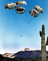
Airdrop on the Yuma Proving Ground

Trails and unimproved road trails

[edit]

Some of the local trails are: King Valley Road, McPherson Pass Trail, Big Eye Wash Trail, Castle Dome Mountains, and Kofa Queen Canyon Trail.

See also

[edit]

References

[edit]
  1. ^ "Castle Dome Peak". Geographic Names Information System. United States Geological Survey, United States Department of the Interior.
  • ^ a b "Castle Dome Peak, Arizona". Peakbagger.com. Retrieved 2021-11-13.
  • ^ Castle Dome District, Castle Dome Mts, Yuma Co., Arizona, USA, Mindat.org
  • [edit]
    Retrieved from "https://en.wikipedia.org/w/index.php?title=Castle_Dome_(butte)&oldid=1193265835"

    Categories: 
    Buttes of Arizona
    Yuma Desert
    Landforms of Yuma County, Arizona
    Lower Colorado River Valley
    Tourist attractions in Yuma County, Arizona
    Hidden categories: 
    Pages using gadget WikiMiniAtlas
    Articles with short description
    Short description is different from Wikidata
    Coordinates on Wikidata


    This page was last edited on 2 January 2024, at 22:47 (UTC).

    Text is available under the Creative Commons Attribution-ShareAlike License 4.0; additional terms may apply. By using this site, you agree to the Terms of Use and Privacy Policy. Wikipedia® is a registered trademark of the Wikimedia Foundation, Inc., a non-profit organization.


    Privacy policy

    About Wikipedia

    Disclaimers

    Contact Wikipedia

    Code of Conduct

    Developers

    Statistics

    Cookie statement

    Mobile view


    Wikimedia Foundation
    Powered by MediaWiki