Jump to content


Main menu


Navigation  


Main page
Contents
Current events
Random article
About Wikipedia
Contact us
Donate


Contribute  


Help
Learn to edit
Community portal
Recent changes
Upload file


Search  


Create account

Log in


Create account
 Log in


Pages for logged out editors learn more  


Contributions
Talk


Contents


(Top)


1 Great Unconformity, Mazatzal Wilderness region  


2 References  


3 Sources and external links  


Mazatzal Mountains


Cebuano
Deutsch
עברית
مصرى
Русский
 

Edit links


Article
Talk


Read
Edit
View history


Tools


Actions  


Read
Edit
View history


General  


What links here
Related changes
Upload file
Special pages
Permanent link
Page information
Cite this page
Get shortened URL
Download QR code
Wikidata item


Print/export  


Download as PDF
Printable version


In other projects  


Wikimedia Commons


Appearance


Coordinates: 33°4231N 111°2153W / 33.7086568°N 111.3648531°W / 33.7086568; -111.3648531
 

From Wikipedia, the free encyclopedia


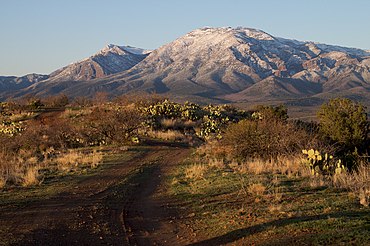
East side of the Mazatzal Mountains, March 2010
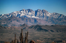
Four Peaks with a snow dusting, from the McDowell Sonoran Preserve, Scottsdale. January 2016

The Mazatzal Mountains (MAH-zaht-ZAL, locally Ma-tuh-ZEL) are a mountain range in south central Arizona, about 30–45 miles northeast of the Phoenix metropolitan area. The origin of the name remains obscure but one possibility is that it is from the Nahuatl language meaning "place of the deer". The crest of the Mazatzals forms the county line between Maricopa County and Gila County. SR 87, the Beeline Highway, traverses the Mazatzals on its way to Payson. The highest peak is Mazatzal Peak at 7,903 feet (2,409 m). They also include the Four Peaks, with elevation 7,659 ft, 2,334 m; a prominent mountain and landmark of the eastern Phoenix area.

The Mazatzal Wilderness Area protects 252,500 acres (1,022 km2) of the Tonto and Coconino National forests. Established in 1940 and expanded to its present size in 1984, elevations range from 2,100 feet (640 m) at Sheep Bridge in the southwest to 7,903 feet (2,409 m) on Mazatzal Peak.

The eastern side of the wilderness consists of brush- or pine-covered mountains, sometimes broken by narrow, vertical-walled canyons. On its west side below the steep brush-covered foothills, the Verde River flows through the Sonoran Desert. The Verde was designated by the U.S. Congress as one of Arizona's two Wild and Scenic Rivers in 1984.

Great Unconformity, Mazatzal Wilderness region

[edit]
The Four Peaks in the Mazatzal Mountains

AtPine, on Arizona State Route 87, at the northeast region of the Mazatzal Wilderness, north terminus of the Mazatzal Mountains, the route traverses the contact between two important geologic units. The horizontally laid Tapeats Sandstone,[1] (common areal extent in Grand Canyon), was deposited on Precambrian granite, the Zoroaster Granite. The time between the erosion of the lower unit and deposition of the horizontal sandstone above, is about 1 billion years (1,000 million years), and is named the Great Unconformity. Besides its occurrence in the Grand Canyon, it is also found west, in the Las Vegas Valley, at Frenchman Mountain. The Zoroaster Granite and other granites, were intruded into the major unit of the Vishnu Schist, the basement paleo unit found in the Inner Gorge region of the Grand Canyon. The neighboring Sierra Ancha range has another occurrence of the Great Unconformity, with a sandstone unit that is an analogue of the Tapeats Sandstone.

The Arizona 87 highway section south of Pine is where the north Mazatzal Mountains merge into the western region of the Mogollon Rim, as the Rim continues northwest into the Oak Creek Canyon region.

References

[edit]
  1. ^ Chronic, Halka (1983). Roadside Geology of Arizona, 23rd printing, Mountain Press Publishing Co. 322 pages. pp. 171–75, 229–32
[edit]

33°42′31N 111°21′53W / 33.7086568°N 111.3648531°W / 33.7086568; -111.3648531


Retrieved from "https://en.wikipedia.org/w/index.php?title=Mazatzal_Mountains&oldid=1101952763"

Categories: 
Arizona transition zone mountain ranges
Mountain ranges of the Sonoran Desert
Mountain ranges of Maricopa County, Arizona
Mountain ranges of Yavapai County, Arizona
Mountain ranges of Gila County, Arizona
Mountain ranges of Arizona
Hidden categories: 
Pages using gadget WikiMiniAtlas
Articles with short description
Short description is different from Wikidata
Commons category link is on Wikidata
Coordinates on Wikidata
Articles with VIAF identifiers
Articles with GND identifiers
Articles with J9U identifiers
Articles with LCCN identifiers
Articles with NKC identifiers
Articles with SUDOC identifiers


This page was last edited on 2 August 2022, at 16:55 (UTC).

Text is available under the Creative Commons Attribution-ShareAlike License 4.0; additional terms may apply. By using this site, you agree to the Terms of Use and Privacy Policy. Wikipedia® is a registered trademark of the Wikimedia Foundation, Inc., a non-profit organization.


Privacy policy

About Wikipedia

Disclaimers

Contact Wikipedia

Code of Conduct

Developers

Statistics

Cookie statement

Mobile view


Wikimedia Foundation
Powered by MediaWiki