Jump to content


Main menu


Navigation  


Main page
Contents
Current events
Random article
About Wikipedia
Contact us
Donate


Contribute  


Help
Learn to edit
Community portal
Recent changes
Upload file


Search  


Create account

Log in


Create account
 Log in


Pages for logged out editors learn more  


Contributions
Talk


Contents


(Top)


1 Geography  


2 History  


3 Administration  


4 References  


5 External links  


Cha-uat district


 / Bân-lâm-gú
Cebuano
Deutsch

িি ি
Italiano
Português
Română

اردو
Tiếng Vit
 

Edit links


Article
Talk


Read
Edit
View history


Tools


Actions  


Read
Edit
View history


General  


What links here
Related changes
Upload file
Special pages
Permanent link
Page information
Cite this page
Get shortened URL
Download QR code
Wikidata item


Print/export  


Download as PDF
Printable version


Appearance


Coordinates: 7°5754N 99°5954E / 7.96500°N 99.99833°E / 7.96500; 99.99833
 

From Wikipedia, the free encyclopedia


Cha-uat
ชะอวด
District location in Nakhon Si Thammarat province
Coordinates: 7°57′54N 99°59′54E / 7.96500°N 99.99833°E / 7.96500; 99.99833
CountryThailand
ProvinceNakhon Si Thammarat
SeatCha-uat
Area
 • Total833.002 km2 (321.624 sq mi)
Population
 (2005)
 • Total84,227
 • Density101.1/km2 (262/sq mi)
Time zoneUTC+7 (ICT)
Postal code80180
Geocode8007

Cha-uat (Thai: ชะอวด, pronounced [t͡ɕʰā.ʔùa̯t]) is a district (amphoe) in the southern part of Nakhon Si Thammarat province, southern Thailand.

Geography

[edit]

Neighboring districts are (from the west clockwise): Thung Song, Chulabhorn, Ron Phibun, Chaloem Phra Kiat, Chian Yai, and Hua Sai of Nakhon Si Thammarat Province; RanotofSongkhla province; Khuan Khanun and Pa PhayomofPhatthalung province; and Huai YotofTrang province.

Khao Pu - Khao Ya National Park is in the Nakhon Si Thammarat mountain range at the boundary of Phatthalung and Trang Provinces.

History

[edit]

The minor district (king amphoe) was created in 1923, when it was split from Ron Phibun district. It was upgraded to a full district on 1 January 1953.[1]

In 1918, the southern railway line was opened to Padang Besar. This route also passes through Cha-uat. It has brought prosperity and trade to the local raising the level to make Cha-uat progress accordingly. Not long after, Thai Chinese settled down to do business. In those days, Cha-uat was one of the important economic zones of Nakhon Si Thammarat.

Later, when more roads were cut, the land transportation route became more convenient, because it can travel directly to the major cities. Cha-uat became just a transit town, but still hides good stuff that are valuable.[2]

Administration

[edit]

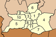
The district is divided into 11 sub-districts (tambons), which are further subdivided into 88 villages (mubans). Cha-uat is a township (thesaban tambon) which covers parts of tambon Cha-uat and Tha Pra Cha. There are a further 11 tambon administrative organizations (TAO).

No. Name Thai name Villages Pop.
1. Cha-uat ชะอวด 9 12,405
2. Tha Samet ท่าเสม็ด 7 4,765
3. Tha Pracha ท่าประจะ 6 7,180
4. Khreng เคร็ง 11 7,654
5. Wang Ang วังอ่าง 10 9,551
6. Ban Tun บ้านตูล 6 6,955
7. Khon Hat ขอนหาด 8 6,147
8. Ko Khan เกาะขันธ์ 9 8,903
9. Khuan Nong Hong ควนหนองหงษ์ 8 6,830
10. Khao Phra Thong เขาพระทอง 7 7,345
11. Nang Long นางหลง 7 6,492
 Map of tambons

References

[edit]
  1. ^ พระราชกฤษฎีกาจัดตั้งอำเภอจักราช อำเภอสัตตหีบ อำเภอศรีสงคราม อำเภอชะอวด อำเภอหนองแซง อำเภอภาชี อำเภอเขาไชยสน อำเภอชุมพลบุรี อำเภอวาริชภูมิ อำเภอสบปราบ และอำเภอสุไหงโกลก พ.ศ. ๒๔๙๖ (PDF). Royal Gazette (in Thai). 70 (17 ก): 368–371. March 10, 1953. Archived from the original (PDF) on April 6, 2012.
  • ^ Page 6 – เยาวชน/สตรี, นั่งรถไฟไปชะอวด หลงเสน่ห์เมืองคอน. Khaosod issues 11,874 vol.33 Friday, June 2, 2023 (in Thai)
  • [edit]
  • t
  • e

  • Retrieved from "https://en.wikipedia.org/w/index.php?title=Cha-uat_district&oldid=1158143050"

    Categories: 
    Districts of Nakhon Si Thammarat province
    Southern Thailand geography stubs
    Hidden categories: 
    Pages using gadget WikiMiniAtlas
    CS1 uses Thai-language script (th)
    CS1 Thai-language sources (th)
    Articles with Thai-language sources (th)
    Articles needing additional references from September 2019
    All articles needing additional references
    Articles with short description
    Short description is different from Wikidata
    Coordinates on Wikidata
    Articles containing Thai-language text
    Pages with Thai IPA
    All stub articles


    This page was last edited on 2 June 2023, at 06:18 (UTC).

    Text is available under the Creative Commons Attribution-ShareAlike License 4.0; additional terms may apply. By using this site, you agree to the Terms of Use and Privacy Policy. Wikipedia® is a registered trademark of the Wikimedia Foundation, Inc., a non-profit organization.


    Privacy policy

    About Wikipedia

    Disclaimers

    Contact Wikipedia

    Code of Conduct

    Developers

    Statistics

    Cookie statement

    Mobile view


    Wikimedia Foundation
    Powered by MediaWiki