Jump to content


Main menu


Navigation  


Main page
Contents
Current events
Random article
About Wikipedia
Contact us
Donate


Contribute  


Help
Learn to edit
Community portal
Recent changes
Upload file


Search  


Create account

Log in


Create account
 Log in


Pages for logged out editors learn more  


Contributions
Talk


Contents


(Top)


1 Geography  


2 Administration  


3 References  


4 External links  


Mueang Nakhon Si Thammarat district


 / Bân-lâm-gú
Cebuano
Deutsch

িি ি
Italiano

Português
Română

اردو
Tiếng Vit
 

Edit links


Article
Talk


Read
Edit
View history


Tools


Actions  


Read
Edit
View history


General  


What links here
Related changes
Upload file
Special pages
Permanent link
Page information
Cite this page
Get shortened URL
Download QR code
Wikidata item


Print/export  


Download as PDF
Printable version


In other projects  


Wikimedia Commons


Appearance


Coordinates: 8°2512N 99°5748E / 8.42000°N 99.96333°E / 8.42000; 99.96333
 

From Wikipedia, the free encyclopedia


Mueang Nakhon Si Thammarat district
อำเภอเมืองนครศรีธรรมราช
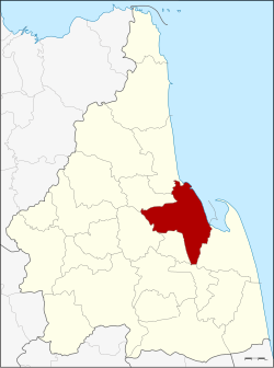
District location in Nakhon Si Thammarat province
Coordinates: 8°25′12N 99°57′48E / 8.42000°N 99.96333°E / 8.42000; 99.96333
CountryThailand
ProvinceNakhon Si Thammarat
SeatNai Mueang
Area
 • Total617.4 km2 (238.4 sq mi)
Population
 (2009)
 • Total266,613
 • Density431.83/km2 (1,118.4/sq mi)
Time zoneUTC+7 (ICT)
Postal code80000
Geocode8001

Mueang Nakhon Si Thammarat (Thai: อำเภอเมืองนครศรีธรรมราช, pronounced [mɯ̄a̯ŋ ná(ʔ).kʰɔ̄ːn sǐː tʰām.mā.râːt]) is the capital district (amphoe mueang) of Nakhon Si Thammarat provinceinsouthern Thailand.

Geography[edit]

Neighboring districts are (from the southeast clockwise): Pak Phanang, Chaloem Phra Kiat, Phra Phrom, Lan Saka, Phrom Khiri and Tha Sala. To the east is the Gulf of Thailand.

Administration[edit]

The district is divided into 16 sub-districts (tambons), which are further subdivided into 114 villages (mubans).

No. Name Thai name Villages Pop.     
1. Nai Mueang ในเมือง - 46,364
2. Tha Wang ท่าวัง - 17,234
3. Khlang คลัง - 18,638
6. Tha Rai ท่าไร่ 6 8,437
7. Pak Nakhon ปากนคร 6 12,501
8. Na Sai นาทราย 6 6,124
12. Kamphaeng Sao กำแพงเซา 9 9,784
13. Chaiyamontri ไชยมนตรี 5 6,460
14. Mamuang Song Ton มะม่วงสองต้น 6 4,422
15. Na Khian นาเคียน 8 12,506
16. Tha Ngio ท่างิ้ว 9 10,425
18. Pho Sadet โพธิ์เสด็จ 9 31,709
19. Bang Chak บางจาก 11 11,521
20. Pak Phun ปากพูน 12 36,063
21. Tha Sak ท่าซัก 9 9,743
22. Tha Ruea ท่าเรือ 18 22,968
 Map of tambons

The missing numbers 9-11 and 17 belong to communes which were split off in 1994 to form Phra Phrom District.

Nakhon Si Thammarat itself has city status (thesaban nakhon) and covers tambons Nai Mueang, Tha Wang, Khlang, and parts of Na Khian and Pho Sadet. There are a further three townships (thesaban tambons): Bang Chak covering parts of the same-named tambon, Tha Phae covering parts of tambon Pak Phun, and Pak Nakhon covering parts of tambons Tha Rai and Pak Nakhon. There are also 13 tambon administrative organizations (TAO).

References[edit]

External links[edit]

  • t
  • e

  • Retrieved from "https://en.wikipedia.org/w/index.php?title=Mueang_Nakhon_Si_Thammarat_district&oldid=1161538190"

    Categories: 
    Nakhon Si Thammarat
    Districts of Nakhon Si Thammarat province
    Southern Thailand geography stubs
    Hidden categories: 
    Pages using gadget WikiMiniAtlas
    Articles lacking sources from September 2017
    All articles lacking sources
    Articles with short description
    Short description is different from Wikidata
    Coordinates on Wikidata
    Articles containing Thai-language text
    Pages with Thai IPA
    All stub articles


    This page was last edited on 23 June 2023, at 11:01 (UTC).

    Text is available under the Creative Commons Attribution-ShareAlike License 4.0; additional terms may apply. By using this site, you agree to the Terms of Use and Privacy Policy. Wikipedia® is a registered trademark of the Wikimedia Foundation, Inc., a non-profit organization.


    Privacy policy

    About Wikipedia

    Disclaimers

    Contact Wikipedia

    Code of Conduct

    Developers

    Statistics

    Cookie statement

    Mobile view


    Wikimedia Foundation
    Powered by MediaWiki