Jump to content


Main menu


Navigation  


Main page
Contents
Current events
Random article
About Wikipedia
Contact us
Donate


Contribute  


Help
Learn to edit
Community portal
Recent changes
Upload file


Search  


Create account

Log in


Create account
 Log in


Pages for logged out editors learn more  


Contributions
Talk


Contents


(Top)


1 Geography  


2 History  


3 Administration  


3.1  Central administration  


3.2  Local administration  


4 Local festivals  


5 References  


6 External links  


Dan Sai district


 / Bân-lâm-gú
Cebuano
Deutsch

িি ি
Italiano
Română

اردو
Tiếng Vit
 

Edit links


Article
Talk


Read
Edit
View history


Tools


Actions  


Read
Edit
View history


General  


What links here
Related changes
Upload file
Special pages
Permanent link
Page information
Cite this page
Get shortened URL
Download QR code
Wikidata item


Print/export  


Download as PDF
Printable version


Appearance


Coordinates: 17°1648N 101°848E / 17.28000°N 101.14667°E / 17.28000; 101.14667
 

From Wikipedia, the free encyclopedia


Dan Sai
ด่านซ้าย
Phu Lom Lo, part of Phu Hin Rong Kla National Park, the largest wild Himalayan cherry site in Thailand.
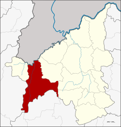
District location in Loei province
Coordinates: 17°16′48N 101°8′48E / 17.28000°N 101.14667°E / 17.28000; 101.14667
CountryThailand
ProvinceLoei
SeatDan Sai
Subdistricts10
Mubans99
Area
 • Total1,732.0 km2 (668.7 sq mi)
Population
 (2015)
 • Total51,564
 • Density28.4/km2 (74/sq mi)
Time zoneUTC+7 (ICT)
Postal code42120
Geocode4205

Dan Sai (Thai: ด่านซ้าย; IPA: [dàːn sáːj]) is a district (amphoe) in the western part of Loei province, northeastern Thailand.

Phra That Si Song Rak

Geography[edit]

Neighboring districts are (from the east clockwise): Phu Ruea of Loei Province; Lom Kao and Khao KhoofPhetchabun province; Nakhon ThaiofPhitsanulok province; and Na Haeo of Loei. To the north is Xaignabouli provinceofLaos.

The source of the Pa Sak River is in the mountains in the eastern part of the district. A large part of the district is a portion of the Phu Hin Rong Kla National Park. Phu Thap Buek, the highest mountain of the Phetchabun Range, is at the southern end of the district.[1] To the southeast is the Phu Luang Wildlife Sanctuary.

The northern part of the district reaches the southern end of the Luang Prabang Range mountain area of the Thai highlands.[2]

History[edit]

According to General Apirat Kongsompong, on 5 November 1976, King Rama X, then an army captain and crown prince, engaged with communist insurgents in Ban Mak Kheng of Dan Sai District. The general noted that, "His Majesty was in the operation base, ate and slept like other soldiers. His Majesty visited local residents, gave moral support and fought shoulder by shoulder with brave soldiers."[3]

Administration[edit]

Dan Sai town

Central administration[edit]

Dan Sai is divided into 10 sub-districts (tambons), which are further subdivided into 99 administrative villages (mubans).

No. Name Thai Villages Pop.[4]
01. Dan Sai ด่านซ้าย 15 9,490
02. Pak Man ปากหมัน 07 3,034
03. Na Di นาดี 09 3,810
04. Khok Ngam โคกงาม 07 4,854
05. Phon Sung โพนสูง 09 5,026
06. Ipum อิปุ่ม 13 4,723
07. Kok Sathon กกสะทอน 12 7,854
08. Pong โป่ง 11 6,092
09. Wang Yao วังยาว 07 3,686
10. Na Ho นาหอ 09 2,995

Local administration[edit]

There are two sub-district municipalities (thesaban tambons) in the district:

There are nine sub-district administrative organizations (SAO) in the district:

Local festivals[edit]

Dan Sai is the place where Phi Ta Khon traditions are known around the world. The Thai spirit masked festival is held annually after the full moon of the sixth Thai lunar month (around late June to early July).[5]

References[edit]

  • ^ ดร.กระมล ทองธรรมชาติ และคณะ, สังคมศึกษา ศาสนาและวัฒนธรรม ม.1, สำนักพิมพ์ อักษรเจริญทัศน์ อจท. จำกัด, 2548, หน้า 24-25
  • ^ Nanuam, Wassana (11 October 2019). "Army chief: Monarchy, military, people inseparable". Bangkok Post. Reuters. Retrieved 12 October 2019.
  • ^ "Population statistics 2015" (in Thai). Department of Provincial Administration. Retrieved 2016-06-09.
  • ^ "PHI TA KHON FESTIVAL". Royal Thai Embassy Singapore. 2010-06-12. Retrieved 2022-12-06.
  • External links[edit]

  • t
  • e

  • Retrieved from "https://en.wikipedia.org/w/index.php?title=Dan_Sai_district&oldid=1125870595"

    Categories: 
    Districts of Loei province
    Isan geography stubs
    Hidden categories: 
    Pages using gadget WikiMiniAtlas
    CS1 Thai-language sources (th)
    Articles with short description
    Short description is different from Wikidata
    Coordinates on Wikidata
    Articles containing Thai-language text
    Pages with Thai IPA
    All stub articles


    This page was last edited on 6 December 2022, at 09:00 (UTC).

    Text is available under the Creative Commons Attribution-ShareAlike License 4.0; additional terms may apply. By using this site, you agree to the Terms of Use and Privacy Policy. Wikipedia® is a registered trademark of the Wikimedia Foundation, Inc., a non-profit organization.


    Privacy policy

    About Wikipedia

    Disclaimers

    Contact Wikipedia

    Code of Conduct

    Developers

    Statistics

    Cookie statement

    Mobile view


    Wikimedia Foundation
    Powered by MediaWiki