Jump to content


Main menu


Navigation  


Main page
Contents
Current events
Random article
About Wikipedia
Contact us
Donate


Contribute  


Help
Learn to edit
Community portal
Recent changes
Upload file


Search  


Create account

Log in


Create account
 Log in


Pages for logged out editors learn more  


Contributions
Talk


Contents


(Top)


1 History  


2 Geography  


3 Administration  


4 References  


5 External links  


Na Duang district


 / Bân-lâm-gú
Cebuano
Deutsch

িি ি
Italiano
Română

اردو
Tiếng Vit
 

Edit links


Article
Talk


Read
Edit
View history


Tools


Actions  


Read
Edit
View history


General  


What links here
Related changes
Upload file
Special pages
Permanent link
Page information
Cite this page
Get shortened URL
Download QR code
Wikidata item


Print/export  


Download as PDF
Printable version


Appearance


Coordinates: 17°2845N 101°5814E / 17.47917°N 101.97056°E / 17.47917; 101.97056
 

From Wikipedia, the free encyclopedia


Na Duang
นาด้วง
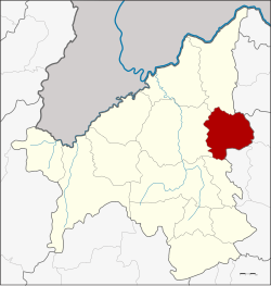
District location in Loei province
Coordinates: 17°28′45N 101°58′14E / 17.47917°N 101.97056°E / 17.47917; 101.97056
CountryThailand
ProvinceLoei
SeatNa Duang
Area
 • Total590.0 km2 (227.8 sq mi)
Population
 (2005)
 • Total25,232
 • Density42.8/km2 (111/sq mi)
Time zoneUTC+7 (ICT)
Postal code42210
Geocode4202

Na Duang (Thai: นาด้วง; IPA: [nāː dûaŋ]) is a district (amphoe) in the eastern part of Loei province, northeastern Thailand.

History

[edit]

The area of the district was originally Ban Na Duang of Udon Thani province, a village named after the hunter Duang. He led people to establish a new village in 1881. Later the village was assigned to be part of tambon Thung Pho, Mueang Loei district in 1945 and tambon Na Din Dam in 1967. In 1976 it was upgraded to a tambon. Together with three more tambons it formed a minor district (king amphoe) on 17 January 1977.[1] It was upgraded to a full district on 19 July 1991.[2]

Geography

[edit]

Neighboring districts are (from the south clockwise): Erawan, Mueang Loei, Pak Chom of Loei Province; Nam SomofUdon Thani province; and Suwannakhuha, Na Klang and Na WangofNong Bua Lamphu province.

Administration

[edit]

The district is divided into four sub-districts (tambons), which are further subdivided into 41 villages (mubans). Na Duang is a township (thesaban tambon) which covers parts of tambon Na Duang. There are a further four tambon administrative organizations (TAO).

No. Name Thai name Villages Pop.
1. Na Duang นาด้วง 12 9,359
2. Na Dok Kham นาดอกคำ 17 9,433
3. Tha Sa-at ท่าสะอาด 7 3,546
4. Tha Sawan ท่าสวรรค์ 5 2,894

References

[edit]
  1. ^ ประกาศกระทรวงมหาดไทย เรื่อง แบ่งท้องที่อำเภอเมืองเลย จังหวัดเลย ตั้งเป็นกิ่งอำเภอนาด้วง (PDF). Royal Gazette (in Thai). 94 (10 ง): 366. 1 February 1977. Archived from the original (PDF) on April 19, 2012.
  • ^ พระราชกฤษฎีกาตั้งอำเภอทุ่งตะโก อำเภอพะโต๊ะ อำเภอเขาค้อ อำเภอน้ำหนาว อำเภอวังจันทร์ อำเภอนาด้วง อำเภอเต่างอย อำเภอสิงหนคร อำเภอพระสมุทรเจดีย์ และอำเภอลำดวน พ.ศ. ๒๕๓๔ (PDF). Royal Gazette (in Thai). 108 (107 ก Special): 29–33. 19 June 1991. Archived from the original (PDF) on November 8, 2011.
  • [edit]


  • t
  • e

  • Retrieved from "https://en.wikipedia.org/w/index.php?title=Na_Duang_district&oldid=1151600142"

    Categories: 
    Districts of Loei province
    Isan geography stubs
    Hidden categories: 
    Pages using gadget WikiMiniAtlas
    CS1 uses Thai-language script (th)
    CS1 Thai-language sources (th)
    Articles with short description
    Short description is different from Wikidata
    Coordinates on Wikidata
    Articles needing additional references from November 2022
    All articles needing additional references
    Articles containing Thai-language text
    Pages with Thai IPA
    All stub articles


    This page was last edited on 25 April 2023, at 01:40 (UTC).

    Text is available under the Creative Commons Attribution-ShareAlike License 4.0; additional terms may apply. By using this site, you agree to the Terms of Use and Privacy Policy. Wikipedia® is a registered trademark of the Wikimedia Foundation, Inc., a non-profit organization.


    Privacy policy

    About Wikipedia

    Disclaimers

    Contact Wikipedia

    Code of Conduct

    Developers

    Statistics

    Cookie statement

    Mobile view


    Wikimedia Foundation
    Powered by MediaWiki