Jump to content


Main menu


Navigation  


Main page
Contents
Current events
Random article
About Wikipedia
Contact us
Donate


Contribute  


Help
Learn to edit
Community portal
Recent changes
Upload file


Search  


Create account

Log in


Create account
 Log in


Pages for logged out editors learn more  


Contributions
Talk


Contents


(Top)


1 Counties  


1.1  In Iowa  


1.2  In Illinois  


2 Communities  


3 Education institutes  


3.1  Higher education  


3.2  Primary and secondary education  


4 Transportation  


4.1  Airports  


4.1.1  Public  


4.2  Transit  


4.3  Interstates  


4.4  Principal Highways  


4.5  State Highways  


5 Shopping  


6 References  


DavenportMolineClinton, Muscatine, IowaIllinois Combined Statistical Area


Add links


Article
Talk


Read
Edit
View history


Tools


Actions  


Read
Edit
View history


General  


What links here
Related changes
Upload file
Special pages
Permanent link
Page information
Cite this page
Get shortened URL
Download QR code
Wikidata item


Print/export  


Download as PDF
Printable version


Appearance


From Wikipedia, the free encyclopedia


Greater Quad Cities CSA
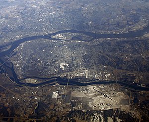
Aerial view of the Quad Cities
Map
Map of Davenport–Moline, IA–IL CSA
Country United States
State Iowa
Illinois
Largest cityDavenport, Iowa
Other citiesMoline, Illinois
Bettendorf, Iowa
Rock Island, Illinois
East Moline, Illinois
Area
 • Total170 sq mi (400 km2)
Highest elevation
850 ft (259 m)
Lowest elevation
590 ft (180 m)
Population
 • Total379,374 (147th)
 • Rank147th in the U.S.
 • Density1,600/sq mi (618/km2)
Time zoneUTC-06:00 (CST)
 • Summer (DST)UTC-05:00 (CDT)

Greater Quad Cities, IA–IL is a nickname for the DavenportMoline, IAIL Combined Statistical Area,[1] an area that is made up of four counties in Iowa and three in Illinois. The statistical area includes one metropolitan areas and two micropolitan area. As of the 2010 Census, the CSA had a population of 471,551 (though a March 2017 estimate placed the population at 472,153).[2]

The area consists of the:

Counties[edit]

In Iowa[edit]

In Illinois[edit]

Communities[edit]

The communities (both incorporated and unincorporated) in the combined statistical area are as follows:

In Iowa
  • Andover
  • Bettendorf
  • Blue Grass
  • Bryant
  • Buffalo
  • Calamus
  • Camanche
  • Charlotte
  • Clinton
  • Columbus City
  • Columbus Junction
  • Cotter
  • Cranston
  • Creekville
  • Delmar
  • DeWitt
  • Dixon
  • Donahue
  • Eldridge
  • Elvira
  • Elwood
  • Fairport
  • Fredonia
  • Goose Lake
  • Grand Mound
  • Grandview
  • Le Claire
  • Letts
  • Long Grove
  • Lost Nation
  • Low Moor
  • Maysville
  • McCausland
  • Midway Beach
  • Montpelier
  • Morning Sun
  • Moscow
  • Mount Joy
  • Muscatine
  • New Liberty
  • Oakville
  • Panorama Park
  • Park View
  • Petersburg
  • Princeton
  • Riverdale
  • Teeds Grove
  • Toolesboro
  • Toronto
  • Walcott
  • Wapello
  • Welton
  • West Liberty
  • Wheatland
  • Wilton
  • In Illinois
  • Aledo
  • Annawan
  • Barstow
  • Cambridge
  • Carbon Cliff
  • Cleveland
  • Coal Valley
  • Dayton
  • East Moline
  • Geneseo
  • Hampton
  • Kewanee
  • Lynn Center
  • Matherville
  • Milan
  • Nekoma
  • North Henderson
  • Ophiem
  • Orion
  • Osco
  • Port Byron
  • Rock Island
  • Sherrard
  • Silvis
  • Education institutes[edit]

    Higher education[edit]

    Eastern Iowa Community Colleges

    Primary and secondary education[edit]

    Transportation[edit]

    Airports[edit]

    Below is a list of the airports in the greater area, followed by their number of enplanements (commercial passenger boardings) that occurred at the airport in calendar year 2013.

    Public[edit]

    Transit[edit]

    Interstates[edit]

    Principal Highways[edit]

    State Highways[edit]

    Shopping[edit]

    Below are some notable shopping centers in the area:

    References[edit]

    1. ^ "OMB Bulletin No. 17-01: Revised Delineations of Metropolitan Statistical Areas, Micropolitan Statistical Areas, and Combined Statistical Areas, and Guidance on Uses of the Delineations of These Areas" (PDF). United States Office of Management and Budget. August 15, 2017. Archived from the original (PDF) on January 21, 2019. Retrieved March 6, 2018.
  • ^ "Annual Estimates of the Resident Population: April 1, 2010 to July 1, 2017 - United States -- Combined Statistical Area; and for Puerto Rico". United States Census Bureau, Population Division. March 2018. Retrieved March 31, 2018.[permanent dead link]

  • Retrieved from "https://en.wikipedia.org/w/index.php?title=Davenport–Moline–Clinton,_Muscatine,_Iowa–Illinois_Combined_Statistical_Area&oldid=1219161919"

    Categories: 
    Davenport, Iowa
    Quad Cities
    Muscatine, Iowa micropolitan area
    Muscatine County, Iowa
    Louisa County, Iowa
    Clinton County, Iowa
    Hidden categories: 
    Pages with non-numeric formatnum arguments
    All articles with dead external links
    Articles with dead external links from March 2020
    Articles with permanently dead external links
    Articles with short description
    Short description is different from Wikidata
    Pages using infobox settlement with no coordinates
    Pages using the Kartographer extension


    This page was last edited on 16 April 2024, at 03:34 (UTC).

    Text is available under the Creative Commons Attribution-ShareAlike License 4.0; additional terms may apply. By using this site, you agree to the Terms of Use and Privacy Policy. Wikipedia® is a registered trademark of the Wikimedia Foundation, Inc., a non-profit organization.


    Privacy policy

    About Wikipedia

    Disclaimers

    Contact Wikipedia

    Code of Conduct

    Developers

    Statistics

    Cookie statement

    Mobile view


    Wikimedia Foundation
    Powered by MediaWiki