Jump to content


Main menu


Navigation  


Main page
Contents
Current events
Random article
About Wikipedia
Contact us
Donate


Contribute  


Help
Learn to edit
Community portal
Recent changes
Upload file


Search  


Create account

Log in


Create account
 Log in


Pages for logged out editors learn more  


Contributions
Talk


Contents


(Top)


1 References  


2 External links  


European route E10


العربية
 / Bân-lâm-gú
Български
Català
Čeština
Dansk
Deutsch
Español
Esperanto
فارسی
Français

Italiano
Kurdî
Latviešu
Lombard
Magyar
Bahasa Melayu
Nederlands

Norsk bokmål
Norsk nynorsk
Polski
Português
Русский
Slovenčina
Suomi
Svenska
Türkçe
Українська


Edit links


Article
Talk


Read
Edit
View history


Tools


Actions  


Read
Edit
View history


General  


What links here
Related changes
Upload file
Special pages
Permanent link
Page information
Cite this page
Get shortened URL
Download QR code
Wikidata item


Print/export  


Download as PDF
Printable version


In other projects  


Wikimedia Commons
Wikivoyage


Appearance


From Wikipedia, the free encyclopedia


E10 shield

E10

Map

Route information
Length880 km (550 mi)
Major junctions
North-West endÅ, Norway
Major intersections E6 Bjerkvik

E45 Gällivare

E4 Luleå
South-East endLuleå, Sweden
Location
Countries Norway
 Sweden
Highway system
View from Raftsund Bridge, E10
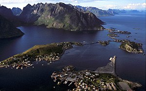
Scenery over Reine near ÅinLofoten, Norway. The E10 goes between the islands.
Scenery near Abisko village in Kiruna Municipality, Sweden.
End of the E10 in Å
Roundabout junction of the E6 and E10 roads at Bjerkvik

European route E10 is the second shortest Class A road which is part of the International E-road network. It begins in Å, Norway and ends in Luleå, Sweden. The road is about 850 km (530 mi) in length. The Norwegian part of the road is also named Kong Olav Vs vei (King Olav V's road).

The road follows the route ÅLeknesSvolværGullesfjordbotnEvenesBjerkvikKirunaTöreLuleå. Most of the road is paved and two-lane, with the exception of some bridges between islands in Nordland.[1] It has a 90–100 km/h (56–62 mph) speed limit in Sweden,[2] and is usually 7-8 meters wide, enough to make encounters between heavy vehicles trouble-free. In Norway the road is much more twisting than in Sweden, and around 6–7,5 m wide usually with a speed limit of 80 km/h (50 mph). New sections have been built 7.5 m (25 ft) wide in the last 15 years, but there are still many narrow parts left. Often, the 6 m (20 ft) width makes encounters between heavy vehicles tight. For the last 50 km, until Å, the road is mostly less than 6 m (20 ft) wide, often 5 m (16 ft). Buses and caravans should avoid driving here, but many of them do so anyway.

The name E10 was given in 1992. Before 1985, E10 was the name of the road Paris-Brussels-Amsterdam-Groningen. The road between Narvik and Kiruna was finished in 1984, before that, no road existed at all directly between the two cities; the only way to travel between them was by train (with passenger services only three times a day), or by a large detour through Finland. In 2007, the road near Lofoten was shortened by about 30 km, and the ferry-service was bypassed for the E10, with the opening of Lofast, a new road between Fiskebøl and Gullesfjordbotn. At the end of 2007, the E10 had 18 tunnels totalling 20.4 km (12.7 mi), all in Norway.

References

[edit]
  1. ^ Google (2019-12-05). "European route E10" (Map). Google Maps. Google. Retrieved 2019-12-05.
  • ^ Nationell vägdatabas (NVDB) [National road database] (Map) (in Swedish). Swedish Transport Administration. Retrieved 2017-11-04.
  • [edit]
  • t
  • e

  • Retrieved from "https://en.wikipedia.org/w/index.php?title=European_route_E10&oldid=1223721497"

    Categories: 
    International E-road network
    Norwegian national roads
    Roads in Sweden
    National Tourist Routes in Norway
    European route E10
    Roads within the Arctic Circle
    Europe road stubs
    Hidden categories: 
    CS1 Swedish-language sources (sv)
    Articles with short description
    Short description is different from Wikidata
    Articles needing additional references from November 2017
    All articles needing additional references
    Infobox road instances in the International E-road network
    Commons category link is on Wikidata
    All stub articles
    Pages using the Kartographer extension


    This page was last edited on 13 May 2024, at 22:49 (UTC).

    Text is available under the Creative Commons Attribution-ShareAlike License 4.0; additional terms may apply. By using this site, you agree to the Terms of Use and Privacy Policy. Wikipedia® is a registered trademark of the Wikimedia Foundation, Inc., a non-profit organization.


    Privacy policy

    About Wikipedia

    Disclaimers

    Contact Wikipedia

    Code of Conduct

    Developers

    Statistics

    Cookie statement

    Mobile view


    Wikimedia Foundation
    Powered by MediaWiki