Jump to content


Main menu


Navigation  


Main page
Contents
Current events
Random article
About Wikipedia
Contact us
Donate


Contribute  


Help
Learn to edit
Community portal
Recent changes
Upload file


Search  


Create account

Log in


Create account
 Log in


Pages for logged out editors learn more  


Contributions
Talk


Contents


(Top)


1 Route  


2 Coordinates  


3 Notes  


4 External links  


European route E80


العربية

 / Bân-lâm-gú
Български
Bosanski
Català
Čeština
Dansk
Deutsch
Ελληνικά
Español
فارسی
Français

Հայերեն
Hrvatski
Bahasa Indonesia
Italiano
Lombard
Magyar
Nederlands

Norsk bokmål
Polski
Português
Română
Русский
Shqip
Slovenčina
Српски / srpski
Suomi
Svenska
Türkçe
Українська
اردو


Edit links


Article
Talk


Read
Edit
View history


Tools


Actions  


Read
Edit
View history


General  


What links here
Related changes
Upload file
Special pages
Permanent link
Page information
Cite this page
Get shortened URL
Download QR code
Wikidata item


Print/export  


Download as PDF
Printable version


In other projects  


Wikimedia Commons


Appearance


From Wikipedia, the free encyclopedia


E80 shield

E80
Route information
Length6,102 km (3,792 mi)
Major junctions
West endPortugal Lisbon, Portugal
East endIran Turkey Gürbulak, iran, Turkey
Location
Countries Portugal
 Spain
 France
 Italy
 Croatia
 Montenegro
 Kosovo
 Serbia
 Bulgaria
 Turkey
 Iran
Highway system
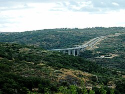
European route 80 in the section Guarda - Vilar Formoso, Portugal.
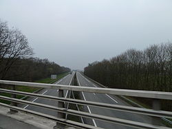
A64 autoroute is a motorway in south western France, at Pau here.
European route 80 near Cocullo, Italy.
European route 80 near Dragoman, Bulgaria (border to Serbia).
Bilingual sign to E 80 in Sofia.

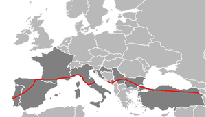
European route E80, also known as the Trans-European MotorwayorTEM, is an A-Class West-East European route, extending from Lisbon, PortugaltoGürbulak, Turkey, on the border with Iran. The road connects 10 countries and has a length of approximately 6,102 kilometres (3,792 mi). At its eastern end it joins end-on with Asian Highway AH1 which continues all the way to Tokyo, Japan.

Route[edit]

 Portugal

 Spain

 France

 Italy

Gap - Adriatic Sea

 Croatia

 Montenegro

 Serbia

 Kosovo

 Serbia

 Bulgaria

 Turkey

 Iran

Coordinates[edit]

Notes[edit]

  1. ^ The route between Montenegro and Kosovo is unclear, a problem currently shared with E65 which is concurrent with E80 on this section. The existing M-2 road that goes through Bijelo Polje continues northwards through western Serbia as E763, away from the direction of Pristina. Instead the route needs to turn to the east some 4 km (2.5 mi) before Bijelo Polje, at Ribarevina junction, and towards Priština. After that, the route goes southeast, throrugh Berane and Rožaje, where the route winds slightly northwards again, goes through western Serbia near Tutin, and then enters Kosovo near Zubin Potok.
  • ^ Previously O-2 was used, it has been banned to use by transit trucks and busses since opening of Yavuz Sultan Selim Bridge.
  • External links[edit]


    Retrieved from "https://en.wikipedia.org/w/index.php?title=European_route_E80&oldid=1228533810"

    Categories: 
    International E-road network
    European routes in Portugal
    Roads in Spain
    Roads in France
    Roads in Italy
    Roads in Croatia
    Roads in Montenegro
    European routes in Kosovo
    Roads in Serbia
    Roads in Bulgaria
    Roads in Turkey
    Hidden categories: 
    Articles with short description
    Short description is different from Wikidata
    Lists of coordinates
    Geographic coordinate lists
    Articles with Geo
    Infobox road maps for Wikidata migration
    Infobox road instances in the International E-road network
    Pages using gadget WikiMiniAtlas
    Commons category link is on Wikidata


    This page was last edited on 11 June 2024, at 19:22 (UTC).

    Text is available under the Creative Commons Attribution-ShareAlike License 4.0; additional terms may apply. By using this site, you agree to the Terms of Use and Privacy Policy. Wikipedia® is a registered trademark of the Wikimedia Foundation, Inc., a non-profit organization.


    Privacy policy

    About Wikipedia

    Disclaimers

    Contact Wikipedia

    Code of Conduct

    Developers

    Statistics

    Cookie statement

    Mobile view


    Wikimedia Foundation
    Powered by MediaWiki