
Original file (3,000 × 1,540 pixels, file size: 4.73 MB, MIME type: image/tiff)
| This is a file from the Wikimedia Commons. Information from its description page there is shown below. Commons is a freely licensed media file repository. You can help. |
| DescriptionPIA17076 fig1-SolanderPoint.tif |
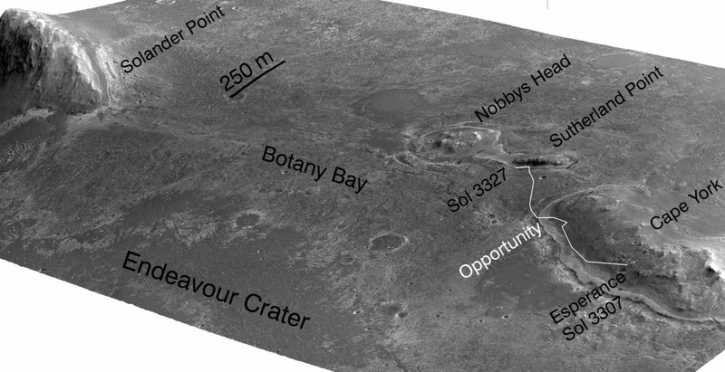
English: A stereo pair of images from taken from Mars orbit were used to generate a digital elevation model that is the basis for this simulated perspective view of "Cape York," "Botany Bay," and "Solander Point" on the western rim of Endeavour Crater. The view is from the crater interior looking toward the southwest, and the vertical exaggeration is fivefold.
|
| Date | |
| Source | http://photojournal.jpl.nasa.gov/catalog/PIA17076 |
| Author | NASA/JPL-Caltech/UA/OSU |
| Public domainPublic domainfalsefalse |
| This file is in the public domain in the United States because it was solely created by NASA. NASA copyright policy states that "NASA material is not protected by copyright unless noted". (See Template:PD-USGov, NASA copyright policy pageorJPL Image Use Policy.) | ||
 |
Warnings:
|
| Date/Time | Thumbnail | Dimensions | User | Comment | |
|---|---|---|---|---|---|
| current | 21:16, 16 November 2013 |  | 3,000 × 1,540 (4.73 MB) | MoreInput | User created page with UploadWizard |
This file contains additional information, probably added from the digital camera or scanner used to create or digitize it.
If the file has been modified from its original state, some details may not fully reflect the modified file.
| Image title | IDL TIFF file |
|---|---|
| Width | 3,000 px |
| Height | 1,540 px |
| Bits per component |
|
| Compression scheme | LZW |
| Pixel composition | RGB |
| Number of components | 3 |
| Number of rows per strip | 1 |
| Horizontal resolution | 577.579 dpi |
| Vertical resolution | 577.579 dpi |
| Data arrangement | chunky format |
| warning | unknown field with tag 37724 (0x935c) encountered. |