Jump to content


Main menu


Navigation  


Main page
Contents
Current events
Random article
About Wikipedia
Contact us
Donate


Contribute  


Help
Learn to edit
Community portal
Recent changes
Upload file


Search  


Create account

Log in


Create account
 Log in


Pages for logged out editors learn more  


Contributions
Talk


Contents


(Top)


1 Solander point  


2 Map showing journey of MER-B near Solander Point  


3 Geological regions around Solander  


4 Rover views of Solander  


5 See also  


6 References  


7 External links  


Solander Point


Add links


Article
Talk


Read
Edit
View history


Tools


Actions  


Read
Edit
View history


General  


What links here
Related changes
Upload file
Special pages
Permanent link
Page information
Cite this page
Get shortened URL
Download QR code
Wikidata item


Print/export  


Download as PDF
Printable version


Appearance


From Wikipedia, the free encyclopedia


North of Solander looking south onto it
Annotated map with location of Solander Point, on Endeavour crater's western rim

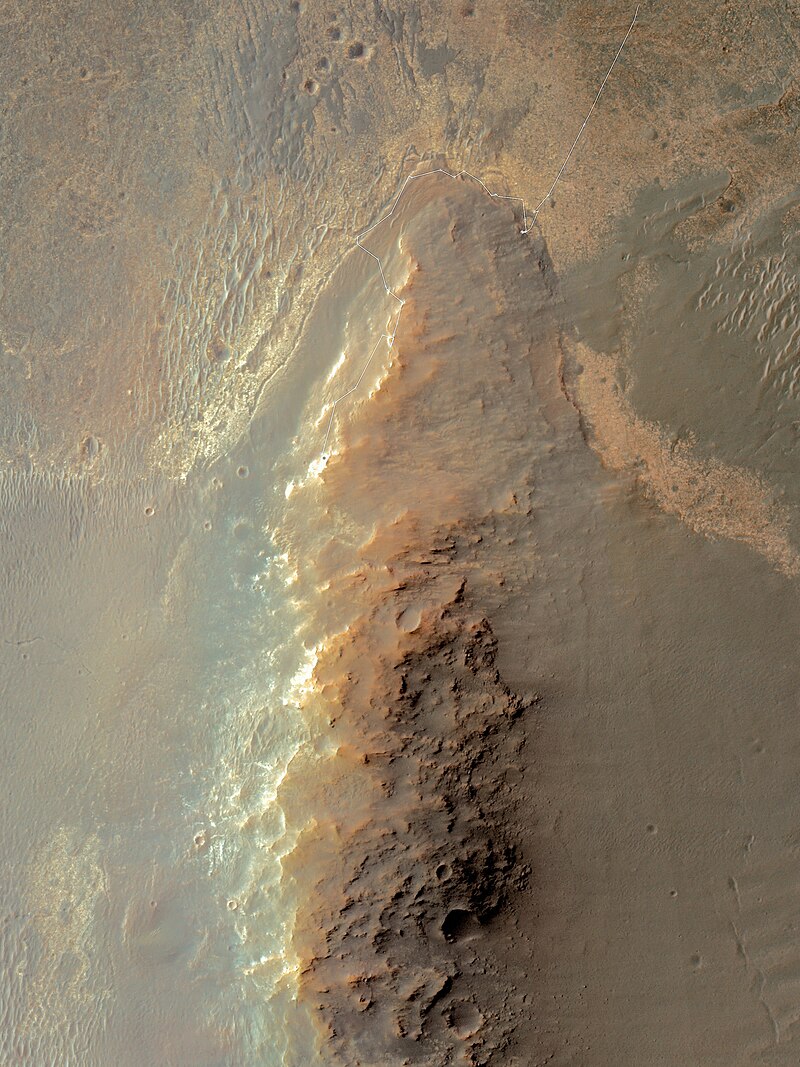
Solander Point is at the north end of the west-southwestern ridgeline of Endeavour crater on the planet Mars. It is named after the Swedish scientist Daniel Solander, who was the first university-educated scientist to set foot on Australian soil at Botany Bay in 1770.

Solander Point was visited in 2013 by the Mars Exploration Rover-B Opportunity, a robotic rover that was active on Mars from 2004-2018. [1]

By early July 2013 Opportunity was approaching it from the North, after previously examining outcrops on the northwest edge of the crater, north of Solander.[2] The rover drove south from Cape York through Botany Bay to travel to Solander.[3] By July 2, 2013, it was about half-way there.[3] The area was imaged from Martian orbit by HiRISE on July 8, 2013, data which aids the rover team in understanding the terrain and planning rover traverses.[4] The rover has been making good time on its approach to Solander, giving the opportunity to investigate a curious area of terrain in the crater.[5][6] At the start of August, the rover was less than 100 meters (328 ft) from Solander,[7] and arrived at its base in the following days.[8] Its arrival signaled the availability of a northward facing slope, useful for angling to collect more sunlight during the Martian winter.[8] In October and November 2013, the rover climbed up the north end of Solander.[9] By December 2013, the rover reached the top of Solander point hill as the 10 year anniversary of its landing on Mars neared.[10] After Solander point Opportunity moved along Murray Ridge, and then south to Cape Tribulation.[11]

Between Solander Point and, to north of it Cape York, both of which are raised up, is a lower area that is noted to be a part of the Burns Formation.[12] The Burns Formation extends all the way back to Opportunity's landing site by Eagle crater, and it was heavily studied prior to this time by the rover.[13] The Burns Formation is "high in sulfate bearing minerals" according to NASA.[14] Solander Point lies at the geological contact line between the Burns Formation, and what is thought to be an even older geological region.[15]
Solander point[edit]

Solander Point with MER-B rover track November 2013
Looking south on Solander Point with the crater floor to the left

Map showing journey of MER-B near Solander Point[edit]

MER-B's arrival and subsequent path around Cape York, and finally its departure as it headed south into Botany Bay towards Solander Point
A different view of its path towards Solander
MER-B's path to Solander Point, and then down along Murray Ridge. (Up to February 2014)

Geological regions around Solander[edit]

Solander Point is a location on the Western Rim of Endeavour crater, shown here in this geological map produced with data from MRO's CRISM instrument

Rover views of Solander[edit]

Looking south along the Western rim of Endeavour crater, Solander Point is the start of the ridge on the right
This is a southward uphill view as the rover ascended the mountain in October 2013. It is assembled from NavCam images.[9]

See also[edit]

References[edit]

  • ^ "NASA - Sol 3351". Archived from the original on 2014-06-20. Retrieved 2013-07-15.
  • ^ a b Mars Rover Opportunity Passes Half-Way Point to Next Destination
  • ^ Overhead View of Mars Rover 10 Years After Launch - NASA
  • ^ The Planetary Society: L. Crumpler - Field Report From Mars: Sol 3363 - July 10, 2013
  • ^ Field Notes from Mars: Sol 3363 - July 10, 2013 Archived October 23, 2013, at the Wayback Machine
  • ^ August 2, 2013 NNM Archived October 21, 2013, at the Wayback Machine August 2, 2013 TPS
  • ^ a b "NASA - Sol 33591". Archived from the original on 2014-06-20. Retrieved 2013-08-13.
  • ^ a b NASA -Mars Rover Opportunity Heads Uphill
  • ^ "Opportunity Rover Starts 2nd Decade by Spectacular Mountain Summit and Mineral Goldmine - Universe Today". Universe Today. 2014-01-19. Retrieved 2018-02-09.
  • ^ mars.nasa.gov. "Mars Exploration Rover". mars.nasa.gov. Retrieved 2018-02-09.
  • ^ "Mars Rover Opportunity Working at Edge of 'Solander'". NASA/JPL. Retrieved 2018-02-09.
  • ^ "Mars Rover Opportunity Working at Edge of 'Solander'". NASA/JPL. Retrieved 2018-02-09.
  • ^ "Mars Rover Opportunity Working at Edge of 'Solander'". NASA/JPL. Retrieved 2018-02-09.
  • ^ "Mars Rover Opportunity Working at Edge of 'Solander'". NASA/JPL. Retrieved 2018-02-09.
  • External links[edit]


    Retrieved from "https://en.wikipedia.org/w/index.php?title=Solander_Point&oldid=1143684371"

    Categories: 
    Margaritifer Sinus quadrangle
    Mars Exploration Rover mission
    Hidden categories: 
    Webarchive template wayback links
    Articles with short description
    Short description is different from Wikidata


    This page was last edited on 9 March 2023, at 07:29 (UTC).

    Text is available under the Creative Commons Attribution-ShareAlike License 4.0; additional terms may apply. By using this site, you agree to the Terms of Use and Privacy Policy. Wikipedia® is a registered trademark of the Wikimedia Foundation, Inc., a non-profit organization.


    Privacy policy

    About Wikipedia

    Disclaimers

    Contact Wikipedia

    Code of Conduct

    Developers

    Statistics

    Cookie statement

    Mobile view


    Wikimedia Foundation
    Powered by MediaWiki