
Fort Mitchell
| |
|---|---|
 Fort Mitchell Location in Alabama. | |
| Coordinates: 32°20′30″N 85°01′18″W / 32.34167°N 85.02167°W / 32.34167; -85.02167 | |
| Country | United States |
| State | Alabama |
| County | Russell |
| Elevation | 354 ft (108 m) |
| Time zone | UTC-6 (Central (CST)) |
| • Summer (DST) | UTC-5 (CDT) |
| ZIP code |
36856[1]
|
| Area code | 334 |
| GNIS feature ID | 118523[2] |
Fort Mitchell is an unincorporated communityinRussell County, Alabama, United States. The settlement developed around a garrisoned fort intended to provide defense for the area during the Creek War (1813–14).[3]
Fort Mitchell is about 10 miles south of Phenix City, Alabama and Columbus, Georgia; Fort Moore lies on the opposite side of the Chattahoochee River from Fort Mitchell.
The community is the home of the Fort Mitchell National Cemetery, established in 1987 for interment of all US veterans.[4]
A major United States fur trade factory was situated here between 1795 and 1807 before it was moved a few miles south to Hiawassee .[5]
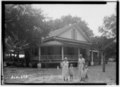
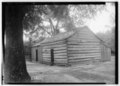
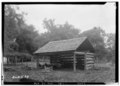
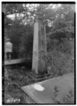
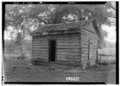
Below are photographs taken in Fort Mitchell as part of the Historic American Buildings Survey:

|
Municipalities and communities of Russell County, Alabama, United States
| ||
|---|---|---|
| City |
|
|
| Town |
| |
| CDP |
| |
| Unincorporated communities |
| |
| Former city |
| |
| Footnotes | ‡This populated place also has portions in an adjacent county or counties | |
| ||
|
| ||
|---|---|---|
| Central cities/largest cities |
| 
Columbus, Georgia Metropolitan Statistical Area
Auburn, Alabama Metropolitan Statistical Area
Tuskegee, Alabama Micropolitan Statistical Area
(defunct)
|
| Cities in Georgia |
| |
| Cities in Alabama |
| |
| Counties in Georgia |
| |
| Counties in Alabama |
| |
| International |
|
|---|---|
| National |
|
| Other |
|
This Russell County, Alabama state location article is a stub. You can help Wikipedia by expanding it. |
