Jump to content


Main menu


Navigation  


Main page
Contents
Current events
Random article
About Wikipedia
Contact us
Donate


Contribute  


Help
Learn to edit
Community portal
Recent changes
Upload file


Search  


Create account

Log in


Create account
 Log in


Pages for logged out editors learn more  


Contributions
Talk


Contents


(Top)


1 See also  


2 References  


Gadfa


العربية
Brezhoneg
Cymraeg
مصرى
 

Edit links


Article
Talk


Read
Edit
View history


Tools


Actions  


Read
Edit
View history


General  


What links here
Related changes
Upload file
Special pages
Permanent link
Page information
Cite this page
Get shortened URL
Download QR code
Wikidata item


Print/export  


Download as PDF
Printable version


Appearance


Coordinates: 53°2259N 4°1857W / 53.383023°N 4.315814°W / 53.383023; -4.315814
 

From Wikipedia, the free encyclopedia


Gadfa

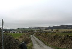
An access road that runs west from the A5025 to Penterfyn-Gadfa.

Gadfa is located in Anglesey
Gadfa

Gadfa

Location within Anglesey

OS grid referenceSH 4607 8985
• Cardiff140 mi (230 km)
• London218.8 mi (352.1 km)
Community
Principal area
CountryWales
Sovereign stateUnited Kingdom
Post townPenysarn
PoliceNorth Wales
FireNorth Wales
AmbulanceWelsh
UK Parliament
Senedd Cymru – Welsh Parliament
List of places
UK
Wales
Anglesey
53°22′59N 4°18′57W / 53.383023°N 4.315814°W / 53.383023; -4.315814

Gadfa is a hamlet in the communityofLlaneilian, Anglesey, Wales, which is 140 miles (225.3 km) from Cardiff and 218.8 miles (352.1 km) from London.

The dispersed settlement has a scatter of buildings mainly along and to the west of the A5025, with a smaller number on the eastern side of the road.[1]

See also[edit]

Map

About OpenStreetMaps

Maps: terms of use

2km
1.2miles

Ynys
Dulas

Lligwy Bay

R H O S Y B O L

L L A N E I L I A N

St Gwenllwyfo's Church

Church of
St Gwenllwyfo

St Gwenllwyfo's Church

Old Church of St Gwenllwyfo, Llanwenllwyfo.

Old St Gwenllwyfo
(remains)

Old Church of St Gwenllwyfo, Llanwenllwyfo.

Church of St Eilian

Church of
St Eilian

Nebo

Penysarn

Llaneilian

Amlwch

City Dulas

Traeth Dulas

Gadfa

Gadfa

Mynydd Eilian

Mynydd
Eilian

Porth Eilian

Pengorffwysfa

Point Lynas Lighthouse

Point Lynas
Lighthouse


Map of Llaneilian Community, showing Gadfa and the surrounding area.[1]

References[edit]

  1. ^ a b historicwales.gov.uk the map enabled portal for historic environment in Llaneilian. Accessed 15 November 2017


  • t
  • e

  • Retrieved from "https://en.wikipedia.org/w/index.php?title=Gadfa&oldid=1160732499"

    Categories: 
    Villages in Anglesey
    Anglesey geography stubs
    Hidden categories: 
    Pages using gadget WikiMiniAtlas
    Use dmy dates from October 2019
    Articles needing additional references from October 2019
    All articles needing additional references
    Articles with short description
    Short description is different from Wikidata
    Articles with OS grid coordinates
    Coordinates on Wikidata
    Articles containing OSM location maps
    All stub articles
    Pages using the Kartographer extension


    This page was last edited on 18 June 2023, at 12:09 (UTC).

    Text is available under the Creative Commons Attribution-ShareAlike License 4.0; additional terms may apply. By using this site, you agree to the Terms of Use and Privacy Policy. Wikipedia® is a registered trademark of the Wikimedia Foundation, Inc., a non-profit organization.


    Privacy policy

    About Wikipedia

    Disclaimers

    Contact Wikipedia

    Code of Conduct

    Developers

    Statistics

    Cookie statement

    Mobile view


    Wikimedia Foundation
    Powered by MediaWiki