Jump to content


Main menu


Navigation  


Main page
Contents
Current events
Random article
About Wikipedia
Contact us
Donate


Contribute  


Help
Learn to edit
Community portal
Recent changes
Upload file


Search  


Create account

Log in


Create account
 Log in


Pages for logged out editors learn more  


Contributions
Talk


Contents


(Top)


1 Geology  


2 Major peaks of Garhwal Himalayas  


3 Demographics  


4 See also  


5 References  


Garhwal Himalayas


Deutsch

ि

Norsk bokmål

پنجابی

Slovenčina
 

Edit links


Article
Talk


Read
Edit
View history


Tools


Actions  


Read
Edit
View history


General  


What links here
Related changes
Upload file
Special pages
Permanent link
Page information
Cite this page
Get shortened URL
Download QR code
Wikidata item


Print/export  


Download as PDF
Printable version


In other projects  


Wikimedia Commons


Appearance


Coordinates: 30°3701N 78°5404E / 30.6170°N 78.9010°E / 30.6170; 78.9010
 

From Wikipedia, the free encyclopedia


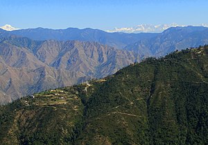
Garhwal Himalaya from "Camel's Back", Uttarakhand, India

The Garhwal Himalayas are mountain ranges located in the Indian state of Uttarakhand.[1][2][3]

Geology[edit]

This range is also a part of Himalaya Sivalik Hills, the outer most hills of the Himalaya located in Himachal Pradesh and Uttarakhand.

Major peaks of Garhwal Himalayas[edit]

Demographics[edit]

The cities which are included in these ranges are Pauri, Tehri, Uttarkashi, Rudraprayag, Chamoli, and Chota Char Dham pilgrimage namely Gangotri, Yamunotri, Badrinath and Kedarnath. Some of the sites of the location are the hill stations of Mussoorie,[4] Dhanaulti, Auli, Chakrata, Chopta, UNESCO World Heritage Site, Nanda Devi and Valley of Flowers National Parks is also located in Garhwal Himalaya.

See also[edit]

References[edit]

  1. ^ Rawat, Ajay S. (November 2002). Garhwal Himalayas: A Study in Historical Perspective. Indus Publishing. ISBN 978-81-7387-136-8.
  • ^ Kapadia, Harish (1999). Across Peaks & Passes in Garhwal Himalaya. Indus Publishing. ISBN 978-81-7387-097-2.
  • ^ "an empirical study of Garhwal Himalaya". ResearchGate. Retrieved 12 July 2021.
  • ^ Chisholm, Hugh, ed. (1911). "Siwalik Hills" . Encyclopædia Britannica. Vol. 25 (11th ed.). Cambridge University Press.
  • 30°37′01N 78°54′04E / 30.6170°N 78.9010°E / 30.6170; 78.9010


    Retrieved from "https://en.wikipedia.org/w/index.php?title=Garhwal_Himalayas&oldid=1177410802"

    Categories: 
    Mountain ranges of the Himalayas
    Mountain ranges of India
    Hidden categories: 
    Wikipedia articles incorporating a citation from the 1911 Encyclopaedia Britannica with Wikisource reference
    Pages using gadget WikiMiniAtlas
    Articles with short description
    Short description is different from Wikidata
    Use dmy dates from September 2017
    Use Indian English from September 2017
    All Wikipedia articles written in Indian English
    Coordinates on Wikidata


    This page was last edited on 27 September 2023, at 13:40 (UTC).

    Text is available under the Creative Commons Attribution-ShareAlike License 4.0; additional terms may apply. By using this site, you agree to the Terms of Use and Privacy Policy. Wikipedia® is a registered trademark of the Wikimedia Foundation, Inc., a non-profit organization.


    Privacy policy

    About Wikipedia

    Disclaimers

    Contact Wikipedia

    Code of Conduct

    Developers

    Statistics

    Cookie statement

    Mobile view


    Wikimedia Foundation
    Powered by MediaWiki