
Garrel
| |
|---|---|
 | |

Flag 
Coat of arms | |
Location of Garrel within Cloppenburg district 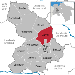 | |
 Garrel Show map of Germany  Garrel Show map of Lower Saxony | |
| Coordinates: 52°57′29″N 8°1′31″E / 52.95806°N 8.02528°E / 52.95806; 8.02528 | |
| Country | Germany |
| State | Lower Saxony |
| District | Cloppenburg |
| Subdivisions | 12 districts |
| Government | |
| • Mayor (2019–24) | Thomas Höffmann[1] |
| Area | |
| • Total | 113.23 km2 (43.72 sq mi) |
| Elevation | 20 m (70 ft) |
| Population
(2022-12-31)[2]
| |
| • Total | 15,762 |
| • Density | 140/km2 (360/sq mi) |
| Time zone | UTC+01:00 (CET) |
| • Summer (DST) | UTC+02:00 (CEST) |
| Postal codes |
49681
|
| Dialling codes | 04474, 04471 |
| Vehicle registration | CLP |
| Website | www.garrel.de |
Garrel is a municipality in the district of Cloppenburg, in Lower Saxony, Germany. It is situated approximately 15 km north of Cloppenburg, and 25 km southwest of Oldenburg.
|
Towns and municipalities in Cloppenburg (district)
| ||
|---|---|---|
|
| |
| International |
|
|---|---|
| National |
|
This Cloppenburg district location article is a stub. You can help Wikipedia by expanding it. |
