Jump to content


Main menu


Navigation  


Main page
Contents
Current events
Random article
About Wikipedia
Contact us
Donate


Contribute  


Help
Learn to edit
Community portal
Recent changes
Upload file


Search  


Create account

Log in


Create account
 Log in


Pages for logged out editors learn more  


Contributions
Talk


Contents


(Top)


1 History  


2 Notable places  


3 References  


4 External links  


Saterland


Ænglisc
 / Bân-lâm-gú
Български
Català
Cebuano
Dansk
Deutsch
Dolnoserbski
Eesti
Español
Esperanto
Euskara
فارسی
Français
Frysk
Hornjoserbsce
Italiano
Lietuvių
Livvinkarjala
Magyar
Македонски
Bahasa Melayu
Nederlands
Nedersaksies
Нохчийн
Nordfriisk
Oʻzbekcha / ўзбекча
Plattdüütsch
Polski
Português
Română
Русский
Seeltersk
Simple English
Српски / srpski
Srpskohrvatski / српскохрватски
Suomi
Svenska
Татарча / tatarça

Українська
اردو
Tiếng Vit
Winaray


Edit links


Article
Talk


Read
Edit
View history


Tools


Actions  


Read
Edit
View history


General  


What links here
Related changes
Upload file
Special pages
Permanent link
Page information
Cite this page
Get shortened URL
Download QR code
Wikidata item


Print/export  


Download as PDF
Printable version


In other projects  


Wikimedia Commons


Appearance


Coordinates: 53°2N 7°43E / 53.033°N 7.717°E / 53.033; 7.717
 

From Wikipedia, the free encyclopedia


Saterland
Seelterlound
Church of Saints Peter and Paul
Flag of Saterland
Coat of arms of Saterland
Location of Saterland within Cloppenburg district
Cloppenburg (district)Lower SaxonyGarrelBöselFriesoytheBarßelSaterlandLöningenEssenCappelnLastrupLindernCloppenburgMolbergenEmstekOsnabrück (district)EmslandLeer (district)AmmerlandOldenburg (district)Vechta (district)
Saterland is located in Germany
Saterland

Saterland

Saterland is located in Lower Saxony
Saterland

Saterland

Coordinates: 53°2′N 7°43′E / 53.033°N 7.717°E / 53.033; 7.717
CountryGermany
StateLower Saxony
DistrictCloppenburg
Subdivisions4 districts
Government
 • Mayor (2018–23) Thomas Otto[1] (Greens)
Area
 • Total123.62 km2 (47.73 sq mi)
Elevation
5 m (16 ft)
Population
 (2022-12-31)[2]
 • Total14,294
 • Density120/km2 (300/sq mi)
Time zoneUTC+01:00 (CET)
 • Summer (DST)UTC+02:00 (CEST)
Postal codes
26683
Dialling codes0 44 92 (Scharrel, Sedelsberg) 0 44 98 (Ramsloh, Strücklingen)
Vehicle registrationCLP
Websitewww.saterland.de

Saterland (German pronunciation: [ˈzaːtɐˌlant]; Saterland Frisian: Seelterlound, pronounced [ˈseːltɐˌloːunt]) is a municipality in the district of Cloppenburg, in Lower Saxony, Germany. It is situated between the cities of Leer, Cloppenburg, and Oldenburg. It is home to Saterland Frisians, who speak Frisian in addition to German.

The municipality of Saterland was formed in 1974, when the smaller municipalities Strücklingen (Strukelje in Saterland Frisian), Ramsloh (Roomelse), Sedelsberg (Seeidelsbierich) and Scharrel (Schäddel) were merged.
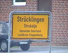
A bilingual road sign in German and Saterland Frisian

History[edit]

Inmedieval times, the Saterland was a sandy region occupying an area of about 15 km long by 1–4 km wide surrounded by marshes. It was settled between the 10th and 13th centuries by Frisians from East Frisia. Being relatively isolated, the inhabitants developed their own form of the East Frisian language, Saterland Frisian, which survives to this day. The "Saterfriesen," as the speakers of this language are called in German, are the smallest minority recognized by the federal government.

Notable places[edit]

On the area of the municipality of Saterland is the VLF transmitter DHO38, a large VLF transmitter of the German Navy for sending commands to submarines.

References[edit]

  1. ^ "Verzeichnis der direkt gewählten Bürgermeister/-innen und Landräte/Landrätinnen". Landesamt für Statistik Niedersachsen. April 2021.
  • ^ "LSN-Online Regionaldatenbank, Tabelle A100001G: Fortschreibung des Bevölkerungsstandes, Stand 31. Dezember 2022" (in German). Landesamt für Statistik Niedersachsen.
  • External links[edit]


    Retrieved from "https://en.wikipedia.org/w/index.php?title=Saterland&oldid=1226056228"

    Categories: 
    Municipalities in Lower Saxony
    Cloppenburg (district)
    Hidden categories: 
    Pages using gadget WikiMiniAtlas
    CS1 German-language sources (de)
    Articles with short description
    Short description is different from Wikidata
    Articles containing Saterland Frisian-language text
    Coordinates on Wikidata
    Pages with German IPA
    Pages with Saterland Frisian IPA
    Commons category link is on Wikidata
    Articles with Saterland Frisian-language sources (stq)
    Articles with German-language sources (de)
    Articles with VIAF identifiers
    Articles with WorldCat Entities identifiers
    Articles with GND identifiers


    This page was last edited on 28 May 2024, at 09:11 (UTC).

    Text is available under the Creative Commons Attribution-ShareAlike License 4.0; additional terms may apply. By using this site, you agree to the Terms of Use and Privacy Policy. Wikipedia® is a registered trademark of the Wikimedia Foundation, Inc., a non-profit organization.


    Privacy policy

    About Wikipedia

    Disclaimers

    Contact Wikipedia

    Code of Conduct

    Developers

    Statistics

    Cookie statement

    Mobile view


    Wikimedia Foundation
    Powered by MediaWiki