Jump to content


Main menu


Navigation  


Main page
Contents
Current events
Random article
About Wikipedia
Contact us
Donate


Contribute  


Help
Learn to edit
Community portal
Recent changes
Upload file


Search  


Create account

Log in


Create account
 Log in


Pages for logged out editors learn more  


Contributions
Talk


Contents


(Top)


1 Name  


2 Ancient geography  


3 Location  


4 Environmental issues  


5 See also  


6 References  


Gediz River


Azərbaycanca
Беларуская
Български
Català
Cebuano
Čeština
Deutsch
Ελληνικά
Español
Esperanto
Euskara
Français
Hrvatski
Bahasa Indonesia
Italiano
Lietuvių
Magyar
مصرى
Norsk nynorsk
Polski
Română
Русский
Srpskohrvatski / српскохрватски
Svenska
Türkçe
Удмурт
Українська


Edit links


Article
Talk


Read
Edit
View history


Tools


Actions  


Read
Edit
View history


General  


What links here
Related changes
Upload file
Special pages
Permanent link
Page information
Cite this page
Get shortened URL
Download QR code
Wikidata item


Print/export  


Download as PDF
Printable version


In other projects  


Wikimedia Commons


Appearance


Coordinates: 38°3518N 26°4857E / 38.58833°N 26.81583°E / 38.58833; 26.81583
 

From Wikipedia, the free encyclopedia


Gediz River
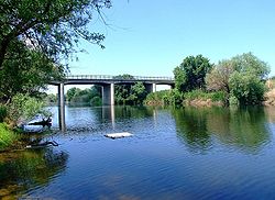
Gediz River in its downstream section crossing İzmir Province
Location
CountryTurkey
Physical characteristics
SourceMount Murat
 • locationKütahya Province
MouthGediz River Delta

 • location

Foça, İzmir Province

 • coordinates

38°35′18N 26°48′57E / 38.58833°N 26.81583°E / 38.58833; 26.81583
Length401 km (249 mi)

The Gediz River (Turkish: Gediz Nehri, Turkish pronunciation: [ˈɡediz]), anciently known as the Hermus River (Ancient Greek: Έρμος), is the second-longest river in Anatolia flowing into the Aegean Sea. From its source of Mount MuratinKütahya Province, it flows generally west for 401 km (249 mi) to the Gediz River Delta in the Gulf of İzmir.

Name

[edit]

The ancient Greek name of the river was Hermos (Ἕρμος), Latinized as Hermus.

The name of the river Gediz may be related to the Lydian proper name Cadys; Gediz is also the name of a town near the river's sources.[1] The name "Gediz" may also be encountered as a male given name in Turkey.

Ancient geography

[edit]

The Gediz is one of the two candidates for the Hittite placename Seha River, the other being the Bakırçay.[2]

The Hermos separated Aeolia from Ionia, except for Ionic Phocaea, which was north of the Hermos. The valley of the Hermos was the heartland of the ancient Lydian Empire and overlooking the valley was the Lydian capital Sardis.

Location

[edit]

InTurkey's Aegean Region, Gediz River's length is second only to Büyük Menderes River whose flow is roughly parallel at a distance of slightly more than a hundred kilometers to the south.

Gediz River rises from Murat Mountain and Şaphane MountaininKütahya Province and flows through Uşak, Manisa and İzmir Provinces. It joins the sea in the northern section of the Gulf of İzmir, close to the gulf's mouth, near the village of Yenibağarası in Foça district, south of the center of the district.

The Gediz Basin lies between northern latitudes of 38°04’–39°13’ and southern longitudes of 26°42’–29°45’. It covers 2.2% of the total area of Turkey. Larger part of the alluvial plain called under the same name as the river (Gediz Plain) is within the area of Manisa Province and a smaller downstream section within İzmir Province.

Environmental issues

[edit]

The Gediz Delta is important as a nature reserve and is home to rare bird species.[3] However, the reserve suffers from water shortages due to heavy demands from irrigation projects, connected to the Demirköprü Dam.[4]

High level of urbanization and industrialization along its basin have caused the Gediz River to suffer severe pollution, particularly by sand and gravel quarries and leather industry. These factors contributed to the river's formerly rich fish reserves to become a thing of the past in recent years.

See also

[edit]

References

[edit]
  1. ^ The association with the nearly fully historical 8th century BC Lydian Cadys is made primarily in a number of Turkish sources
  • ^ Bryce, Trevor (2005). The Trojans and their Neighbours. Taylor & Francis. p. 86. ISBN 978-0-415-34959-8.
  • ^ "Gediz Delta". Ramsar Sites Information Service. Retrieved 25 April 2018.
  • ^ "Case study: Gediz River, Turkey". OPTIMA (Optimisation for Sustainable Water Resources Management).

  • Retrieved from "https://en.wikipedia.org/w/index.php?title=Gediz_River&oldid=1221942112"

    Categories: 
    Rivers of Turkey
    Landforms of Kütahya Province
    Landforms of Uşak Province
    Landforms of Manisa Province
    Landforms of İzmir Province
    Hidden categories: 
    Pages using gadget WikiMiniAtlas
    Articles with short description
    Short description matches Wikidata
    Coordinates on Wikidata
    Articles containing Turkish-language text
    Pages with Turkish IPA
    Commons category link is on Wikidata
    Articles with VIAF identifiers
    Articles with GND identifiers
    Articles with J9U identifiers
    Articles with LCCN identifiers
    Articles with Pleiades identifiers


    This page was last edited on 2 May 2024, at 22:42 (UTC).

    Text is available under the Creative Commons Attribution-ShareAlike License 4.0; additional terms may apply. By using this site, you agree to the Terms of Use and Privacy Policy. Wikipedia® is a registered trademark of the Wikimedia Foundation, Inc., a non-profit organization.


    Privacy policy

    About Wikipedia

    Disclaimers

    Contact Wikipedia

    Code of Conduct

    Developers

    Statistics

    Cookie statement

    Mobile view


    Wikimedia Foundation
    Powered by MediaWiki