Jump to content


Main menu


Navigation  


Main page
Contents
Current events
Random article
About Wikipedia
Contact us
Donate


Contribute  


Help
Learn to edit
Community portal
Recent changes
Upload file


Search  


Create account

Log in


Create account
 Log in


Pages for logged out editors learn more  


Contributions
Talk


Contents


(Top)


1 Places en route  


2 References  


3 External links  


Greensand Way


Add links


Article
Talk


Read
Edit
View history


Tools


Actions  


Read
Edit
View history


General  


What links here
Related changes
Upload file
Special pages
Permanent link
Page information
Cite this page
Get shortened URL
Download QR code
Wikidata item


Print/export  


Download as PDF
Printable version


In other projects  


Wikimedia Commons


Appearance


From Wikipedia, the free encyclopedia


Greensand Way
Crossing the Medway – The Twyford Bridge, Yalding, Kent
Length174 km (108 mi)[1][2]
LocationSouth Eastern England, United Kingdom
TrailheadsHaslemere, Surrey
Hamstreet, Kent
UseHiking
Highest pointLeith Hill, 294 m (965 ft)[3]
SeasonAll year

The Greensand Way is a long-distance path of 108 miles (174 km) in southeast England, from Haslemere in Surrey to Hamstreet in Kent.[1][2] It follows the Greensand Ridge along the Surrey Hills and Chart Hills. The route is mostly rural, passing through woods, and alongside fruit orchards and hop farms in Kent and links with the Stour Valley Walk near Pluckley in Kent. The trail was opened on 15 June 1980 and is jointly managed by Surrey and Kent Councils who fully updated it in 2012 (route, waymarking, online guide).

Much of the land is designated an Area of Outstanding Natural Beauty (AONB). The stretch from Hindhead to Leith Hill has formed part of the Surrey Hills AONB since 1958. The Sevenoaks Ridge, from the Surrey–Kent border to Borough Green, is included in the Kent Downs AONB.

The waymarks alone are not sufficient to follow the trail – an OS map, or the online guide with maps, is required.[4] An updated guide with maps and walk directions is available online from the Kent and Surrey Council websites. The original guidebook is out of print.[5]OnOrdnance Survey Explorer map 145, a spur – also labelled Greensand Way – is shown from Thursley to Farnham; this is not part of the path.
Places en route

[edit]
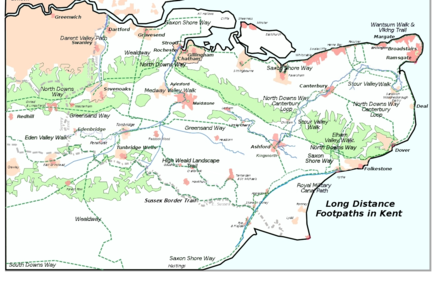
The Greensand Way, and the other long-distance footpathsinKent

Places passed along the trail include: Hindhead, Thursley, Wormley, Hambledon, Hascombe, Shamley Green, Holmbury St Mary, Wotton, Westcott, Dorking, Brockham, Betchworth, Reigate, Earlswood, South Nutfield, Bletchingley, Godstone, Tandridge, Broadham Green, Limpsfield, Crockham Hill, Toys Hill, Ide Hill, Sevenoaks Weald, Knole Park, Shipbourne, Dunk's Green, West Peckham, Nettlestead Green, Yalding, Linton, Sutton Valence, Egerton, Pluckley, Little Chart, Hothfield, Kingsnorth and finally Hamstreet.

References

[edit]
  1. ^ a b "Greensand Way".
  • ^ a b "The Greensand Way long distance route".
  • ^ National Trail
  • ^ "Greensand Way". 16 January 2019.
  • ^ Drewett, J (1985). "Chapter 1: Landscape and Countryside". Surrey. Shire County Guides (2nd ed.). Princes Risborough: Shire Publications. p. 8. ISBN 978-0-7478-0051-4.
  • [edit]
    Retrieved from "https://en.wikipedia.org/w/index.php?title=Greensand_Way&oldid=1226103795"

    Categories: 
    Footpaths in Surrey
    Footpaths in Kent
    Long-distance footpaths in England
    Hidden categories: 
    Articles with short description
    Short description matches Wikidata
    Use dmy dates from May 2017
    Use British English from May 2017
    Commons category link is on Wikidata


    This page was last edited on 28 May 2024, at 15:40 (UTC).

    Text is available under the Creative Commons Attribution-ShareAlike License 4.0; additional terms may apply. By using this site, you agree to the Terms of Use and Privacy Policy. Wikipedia® is a registered trademark of the Wikimedia Foundation, Inc., a non-profit organization.


    Privacy policy

    About Wikipedia

    Disclaimers

    Contact Wikipedia

    Code of Conduct

    Developers

    Statistics

    Cookie statement

    Mobile view


    Wikimedia Foundation
    Powered by MediaWiki