Jump to content


Main menu


Navigation  


Main page
Contents
Current events
Random article
About Wikipedia
Contact us
Donate


Contribute  


Help
Learn to edit
Community portal
Recent changes
Upload file


Search  


Create account

Log in


Create account
 Log in


Pages for logged out editors learn more  


Contributions
Talk


Contents


(Top)


1 Facilities  


2 Future  


3 See also  


4 References  


5 External links  


Griffiss International Airport


فارسی
Română
Тоҷикӣ
اردو
 

Edit links


Article
Talk


Read
Edit
View history


Tools


Actions  


Read
Edit
View history


General  


What links here
Related changes
Upload file
Special pages
Permanent link
Page information
Cite this page
Get shortened URL
Download QR code
Wikidata item


Print/export  


Download as PDF
Printable version


In other projects  


Wikimedia Commons


Appearance


From Wikipedia, the free encyclopedia


Griffiss International Airport
  • ICAO: KRME
  • FAA LID: RME
  • Summary
    Airport typePublic
    OwnerOneida County
    ServesOneida County
    LocationRome, New York
    Elevation AMSL504 ft / 154 m
    Coordinates43°14′02N 075°24′25W / 43.23389°N 75.40694°W / 43.23389; -75.40694
    Websiteocgov.net/airport
    Maps
    FAA airport diagram
    FAA airport diagram
    Map
    Runways
    Direction Length Surface
    ft m
    15/33 11,820 3,603 Concrete
    Statistics (2005)
    Aircraft operations1,000

    Source: Federal Aviation Administration[1]

    View of airport control tower

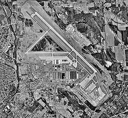
    Griffiss International Airport (IATA: RME, ICAO: KRME, FAA LID: RME) is a public airport located one mile (1.6 km) east of the central business districtofRome, a city in Oneida County, New York, United States. This airport is publicly owned by County of Oneida.[1] It is located on the former site of Griffiss Air Force Base, which closed in 1995. In 1999, the airfield hosted Woodstock '99.

    Operations from the Oneida County AirportinOriskany, New York, were transferred here in 2006, after which the county closed that airport in January 2007.

    In December 2013, Griffiss International Airport was selected as a test site by the United States Federal Aviation Administration to "aid in researching the complexities of integrating Unmanned Aircraft Systems into the congested, northeast airspace." Students from the Rochester Institute of Technology will work with Griffiss to test drones at the airport.[2]

    Griffiss is also a maintenance/storage facility for several regional airlines including Republic Airways, Envoy Airlines, and several more.

    Several aircraft are stored here including: 2 Boeing 747-200s, 1 Boeing 767-200, and 1 Boeing 777-200.

    Facilities[edit]

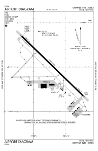
    Griffiss International Airport covers an area of 1,680 acres (680 ha) and contains one runway:[1]

    For 12-month period ending September 13, 2005 the airport had 1,000 aircraft operations:[1]

    Future[edit]

    With the construction of a new terminal building in 2015, public officials hoped to secure additional investment in the facility to attract passenger airlines. The new terminal building also allows for international flights to the airport, as it was constructed to accommodate a US Customs Service-regulation facility for potential international passengers.[3]

    See also[edit]

    References[edit]

    1. ^ a b c d FAA Airport Form 5010 for RME PDF, retrieved March 15, 2007
  • ^ FAA (December 30, 2013). "FAA Selects Six Sites for Unmanned Aircraft Research". Retrieved December 30, 2013.
  • ^ Cooper, Elizabeth (February 26, 2015). "New Griffiss terminal beacon for business?". Utica Observer-Dispatch. Retrieved February 26, 2015.
  • External links[edit]


  • t
  • e

  • Retrieved from "https://en.wikipedia.org/w/index.php?title=Griffiss_International_Airport&oldid=1216836259"

    Categories: 
    Airports in New York (state)
    Transportation buildings and structures in Oneida County, New York
    Transportation in Rome, New York
    Northeastern United States airport stubs
    New York (state) building and structure stubs
    New York (state) transportation stubs
    Hidden categories: 
    Articles with short description
    Short description matches Wikidata
    Use mdy dates from December 2017
    Pages using gadget WikiMiniAtlas
    Infobox mapframe without OSM relation ID on Wikidata
    All stub articles
    Pages using the Kartographer extension


    This page was last edited on 2 April 2024, at 07:35 (UTC).

    Text is available under the Creative Commons Attribution-ShareAlike License 4.0; additional terms may apply. By using this site, you agree to the Terms of Use and Privacy Policy. Wikipedia® is a registered trademark of the Wikimedia Foundation, Inc., a non-profit organization.


    Privacy policy

    About Wikipedia

    Disclaimers

    Contact Wikipedia

    Code of Conduct

    Developers

    Statistics

    Cookie statement

    Mobile view


    Wikimedia Foundation
    Powered by MediaWiki