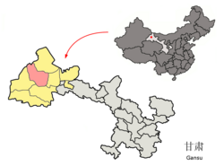

Guazhou County
瓜州县
| |
|---|---|

Guazhou (pink) within Jiuquan prefecture (yellow) within Gansu (grey)
| |
| Country | China |
| Province | Gansu |
| Prefecture-level city | Jiuquan |
| Seat | Yuanquan Town |
| Area | |
| • Total | 24,100 km2 (9,300 sq mi) |
| Population
(2018)
| |
| • Total | 128,133 |
| • Density | 5.3/km2 (14/sq mi) |
| Time zone | UTC+8 (China Standard) |
| Postal code |
736100
|
Guazhou County (Chinese: 瓜州县; pinyin: Guāzhōu Xiàn), formerly (until 2006) Anxi County (安西县; Ānxī Xiàn), is a county in the northwest of Gansu province, China. It is under the administration of Jiuquan City.

Emperor Wudi (140-87 BCE) had the Great Wall extended northwestward all the way to the Gate of Jade (Yumen Pass), the westernmost garrison town near Dunhuang. He then set up a system of garrisons all along this part of the Great Wall and put its headquarters in a town called Anxi (“Tranquil West”) and where the northern and southern Silk Routes historically diverged."[1] The name Guazhou (land/prefecture of melons) has a long contentious history; the name first appeared in records from the Warring States period, but Chinese historians have debated (since the 3rd century) whether it referred to a region in modern-day GansuorShaanxi. From Northern WeitoSui dynasty, Guazhou Prefecture contained both modern-day Dunhuang and Guazhou counties; in the Tang dynasty, the western region surrounding Dunhuang was renamed "Western Shazhou" while the region around Anxi was named Guazhou, with both falling under the administrative unit of "Shazhou". Later, Shazhou became the exclusive name of the region around Dunhuang. The naming of these two regions (Shazhou and Guazhou) largely persisted till the Qing dynasty. In the 18th century, the Qing dynasty replaced the regional names "Shazhou" and "Guazhou" with the names of their largest cities, Dunhuang and Anxi. Since the modern era, Dunhuang County continues to be the name for the western county; however, Anxi County decided to revert to the Guazhou name in 2006 due to its greater recognizability in historical texts, with tourism in mind.[2]
Guazhou County is divided to 9 towns, 1 ethnic town, 2 townships, 3 ethnic townships and 1 other.[3]
|
|
| Climate data for Guazhou, elevation 1,171 m (3,842 ft), (1991–2020 normals) | |||||||||||||
|---|---|---|---|---|---|---|---|---|---|---|---|---|---|
| Month | Jan | Feb | Mar | Apr | May | Jun | Jul | Aug | Sep | Oct | Nov | Dec | Year |
| Mean daily maximum °C (°F) | −1.1 (30.0) |
5.7 (42.3) |
13.7 (56.7) |
21.7 (71.1) |
27.2 (81.0) |
31.4 (88.5) |
33.0 (91.4) |
31.6 (88.9) |
26.8 (80.2) |
19.0 (66.2) |
8.8 (47.8) |
0.1 (32.2) |
18.2 (64.7) |
| Daily mean °C (°F) | −9.3 (15.3) |
−3.2 (26.2) |
4.7 (40.5) |
12.9 (55.2) |
18.9 (66.0) |
23.7 (74.7) |
25.3 (77.5) |
23.5 (74.3) |
17.5 (63.5) |
8.8 (47.8) |
−0.1 (31.8) |
−7.8 (18.0) |
9.6 (49.2) |
| Mean daily minimum °C (°F) | −15.3 (4.5) |
−10.1 (13.8) |
−2.7 (27.1) |
4.9 (40.8) |
10.8 (51.4) |
15.9 (60.6) |
18.2 (64.8) |
16.7 (62.1) |
10.4 (50.7) |
1.8 (35.2) |
−6.1 (21.0) |
−13.4 (7.9) |
2.6 (36.7) |
| Average precipitation mm (inches) | 1.5 (0.06) |
0.8 (0.03) |
2.9 (0.11) |
3.6 (0.14) |
4.6 (0.18) |
8.4 (0.33) |
10.1 (0.40) |
9.8 (0.39) |
3.7 (0.15) |
1.9 (0.07) |
1.3 (0.05) |
2.1 (0.08) |
50.7 (1.99) |
| Average precipitation days (≥ 0.1 mm) | 2.1 | 0.8 | 1.6 | 1.6 | 2.2 | 3.2 | 4.2 | 3.6 | 1.9 | 0.9 | 1.0 | 2.4 | 25.5 |
| Average snowy days | 3.9 | 1.2 | 1.6 | 0.4 | 0 | 0 | 0 | 0 | 0 | 0.2 | 1.5 | 3.5 | 12.3 |
| Average relative humidity (%) | 55 | 39 | 32 | 28 | 28 | 36 | 43 | 43 | 41 | 41 | 49 | 57 | 41 |
| Mean monthly sunshine hours | 210.1 | 216.1 | 259.1 | 280.1 | 311.5 | 300.9 | 302.8 | 297.8 | 281.6 | 266.0 | 216.6 | 193.7 | 3,136.3 |
| Percent possible sunshine | 70 | 71 | 69 | 70 | 69 | 67 | 67 | 71 | 77 | 79 | 74 | 68 | 71 |
| Source: China Meteorological Administration[4][5] | |||||||||||||
The county's location is ideally suited for wind farms, earning the nickname "world's wind warehouse".[6] From the east the wind blows through a high, narrow valley formed by the Qilian and Beishan mountains, reaching 8.3 metres per second and energy density of 703 watts per cubic metre.[6]
The mainline Lanxin Railway and branch line Dunhuang Railway intersect at Liugou Railway Station in the county. Xiaowan and Guazhou are the two other stations on the Dunhuang Railway located in the county.
There are two national highways running through the country, China National Highway 215 (Hongliuyuan) and China National Highway 312 (Hongliuyuan).
39°50′0″N 97°34′0″E / 39.83333°N 97.56667°E / 39.83333; 97.56667
| International |
|
|---|---|
| National |
|