
Halle
Hal (French)
| |
|---|---|
City and municipality
| |

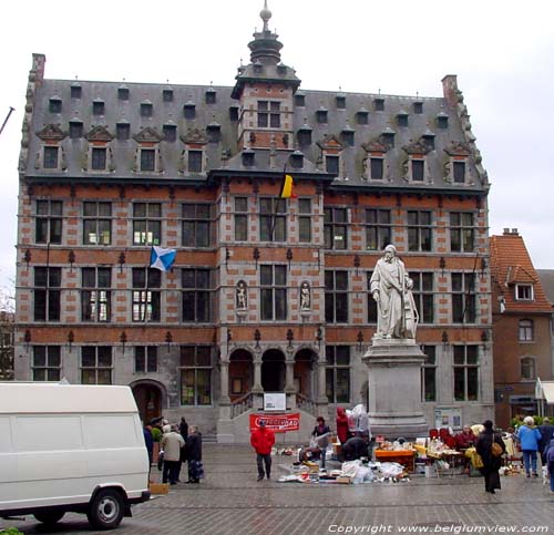
The Grote Markt
| |

Flag 
Coat of arms | |
Location of Halle  | |
 Halle
Location in Belgium
Location of Halle in Flemish Brabant  | |
| Coordinates: 50°44′10″N 04°14′14″E / 50.73611°N 4.23722°E / 50.73611; 4.23722 | |
| Country | |
| Community | Flemish Community |
| Region | Flemish Region |
| Province | Flemish Brabant |
| Arrondissement | Halle-Vilvoorde |
| Government | |
| • Mayor | Marc Snoeck (Vooruit) |
| • Governing party/ies | CD&V, Vooruit, Groen |
| Area | |
| • Total | 44.98 km2 (17.37 sq mi) |
| Population
(2018-01-01)[1]
| |
| • Total | 39,096 |
| • Density | 870/km2 (2,300/sq mi) |
| Postal codes |
1500, 1501, 1502
|
| NIS code |
23027
|
| Area codes | 02 |
| Website | www.halle.be |
Halle (Dutch pronunciation: [ˈɦɑlə] ⓘ; French: Hal, pronounced [al]) is a Belgian city and municipality in the Halle-Vilvoorde district (arrondissement) of the provinceofFlemish Brabant. It is located on the Brussels–Charleroi Canal and on the Flemish side of the language border that separates Flanders and Wallonia. Halle lies on the border between the Flemish plains to the North (thick loam) and the undulating Brabant lands to the South (thinner loam). The city also borders on the Pajottenland to the west. It is about 22 km (14 mi) southwest of Brussels. The official language of Halle is Dutch.
The municipality comprises the city of Halle proper and the towns of Buizingen and Lembeek. The neighboring towns are: Pepingen, Sint-Pieters-Leeuw, Beersel, Braine-l'Alleud, Braine-le-Château, and Tubize. The population of Halle has increased from 32,758 inhabitants in 1991 to 39,536 on 1 January 2019. The mayor is Marc Snoeck of the Vooruit party.
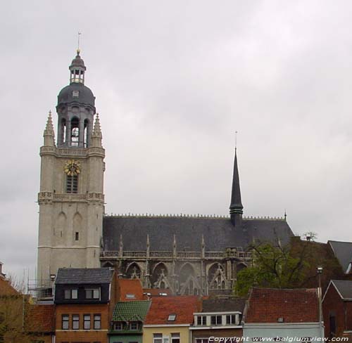
Borders have always played an important role in the history of Halle. Already in the prehistoric era, before the Roman conquests, a tribe of Nervii – either a Germanized Celtic people or a Celticized Germanic people – lived in this region. In the 7th century, Saint Waltrude, the daughter of an important[according to whom?] Merovingian figure, gave some of her inherited land around Halle to the chapter of the abbey which she had just founded in Mons. From that time on and until the French Revolution, the region around Halle would depend to various degrees on the County of Hainaut. In the 8th century, Hubertus, archbishop of Tongeren, founded a church dedicated to the Blessed Virgin Mary. This may have been the start of the regional devotion that continues today. The town must[why?] have grown quickly since Jeanne, Countess of Flanders and Hainaut granted its freedom charters in 1225. The miraculous statue of the Virgin was sent to Halle in 1267 as a wedding gift to John II, Count of Holland and of Hainaut. The cult of Mary attracted important visitors, such as Edward I of England and Ludwig the Bavarian, making Halle an important frontier town between Hainaut and Brabant. A larger church, dedicated to Mary, was completed in the 15th century. The death of Philipe Bold, Duke of Burgundy in Halle in 1404 benefitted the city. All subsequent ruling Dukes of Burgundy paid visits here to honor the duke's grave. In 1460 Louis XI of France decided to bury his stillborn son in the Halle church.
After the death of Mary of Burgundy, Flanders and Brabant revolted against her husband Maximilian. Hainaut, and therefore Halle, remained loyal to the Holy Roman emperor. Two attempts by a Brussels army to conquer Halle in 1489 failed.
In the 16th century, Brussels and Halle were fighting again, this time over religion. Following the Protestant Reformation, the predominately Calvinistic Brabant tried to take over Catholic Hainaut. Again, two attempts failed, leading to an increased devotion among residents to the city's miraculous statue. In 1621, with the support of archdukes Albert and Isabella, the Jesuits were invited to establish educational institutions in the city, expanding their religious influence.
Philip IV of Spain used his stake in Halle and the surrounding area as a warrant against a loan; in 1648 he was forced to cede the city to the Duke of Arenberg. Louis XIV's wars at the end of the century resulted in serious losses. In the 18th century there was a resurgence in devotional and economic prosperity.
The French Revolution at the end of the century suppressed much religious practice. But the pilgrimage site and the statue were spared confiscation thanks to the initiative of the inhabitants. When Napoleon gained power, his government restored religious services. The tradition of Napoleon princely visits to the church of Halle continues until this day.
Today, Halle is a regional services and care center, offering trade, educational establishments, general hospital, and public services (61% of the active population works in the services sector).
Atrain collision in February 2010 in Buizingen killed around 18 people.
The flag of Halle was adopted on 1 October 1991; it is quartered as saltire (argent and azure). Its proportions are 2:3. If you cut the flag in two vertically and flip both sides, you get a blue lozenge, hinting at Bavaria.
On the municipal coat of arms, the first quarter shows an argent-coloured Virgin with Child on an azure background. The fourth quarter is the coat of arms of the Wittelsbach family. The second and third quarters are the coat of arms of Hainaut, accentuating Halle's position on the language border.


Halle is twinned with:
| Czech Republic: Kadaň | |
| Germany: Werl | |
| France: Mouvaux, near Lille |
Places adjacent to Halle, Belgium
| ||||||||||||||||
|---|---|---|---|---|---|---|---|---|---|---|---|---|---|---|---|---|
| ||||||||||||||||
| International |
|
|---|---|
| National |
|
| Geographic |
|
| Other |
|
