Jump to content


Main menu


Navigation  


Main page
Contents
Current events
Random article
About Wikipedia
Contact us
Donate


Contribute  


Help
Learn to edit
Community portal
Recent changes
Upload file


Search  


Create account

Log in


Create account
 Log in


Pages for logged out editors learn more  


Contributions
Talk


Contents


(Top)


1 Extent  


2 References  


3 External links  


Halmahera Sea


Afrikaans
العربية
Asturianu
Azərbaycanca
Basa Bali
Беларуская
Беларуская (тарашкевіца)
Български
Bosanski
Català
Чӑвашла
Čeština
Dansk
Deutsch
Eesti
Español
Esperanto
Euskara
فارسی
Français
Frysk
Galego

Ilokano
Bahasa Indonesia
Íslenska
Italiano
Jawa

Kiswahili
Latviešu
Lietuvių
Magyar
Македонски

مازِرونی
Bahasa Melayu
Nederlands

Nordfriisk
Norsk bokmål
Олык марий
Polski
Português
Русский
Саха тыла
Српски / srpski
Srpskohrvatski / српскохрватски
Suomi
Svenska
ி
Türkçe
Українська
اردو
Tiếng Vit
Winaray


Edit links


Article
Talk


Read
Edit
View history


Tools


Actions  


Read
Edit
View history


General  


What links here
Related changes
Upload file
Special pages
Permanent link
Page information
Cite this page
Get shortened URL
Download QR code
Wikidata item


Print/export  


Download as PDF
Printable version


In other projects  


Wikimedia Commons


Appearance


Coordinates: 1°S 129°E / 1°S 129°E / -1; 129
 

From Wikipedia, the free encyclopedia


Halmahera Sea
Laut Halmahera (Indonesian)
Location of the Halmahera Sea within Southeast Asia
Halmahera Sea is located in Indonesia
Halmahera Sea

Halmahera Sea

Coordinates1°S 129°E / 1°S 129°E / -1; 129
TypeSea
Basin countriesIndonesia
Surface area95,000 km2 (37,000 sq mi)

The Halmahera Sea is a regional sea located in the central eastern part of the Australasian Mediterranean Sea. It is centered at about 1°S and 129°E and is bordered by the Pacific Ocean to the north, Halmahera to the west, Waigeo and West Papua to the east, and the Seram Sea to the south. It covers about 95,000 km (59,000 mi) and its topography comprises a number of separate basins and ridges, the chief of which is the Halmahera Basin reaching a depth of 2039 m.
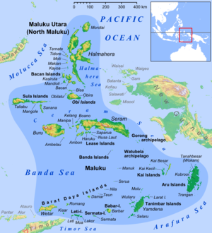
Halmahera Sea in the north of Maluku Islands

Extent

[edit]

The International Hydrographic Organization (IHO) defines the Halmahera Sea as being one of the waters of the East Indian Archipelago. The IHO defines its limits as follows:[1]

On the North A line from Wajaboela (Morotai) to Tg. Djodjefa, the Northern point of Halmahera.

On the East. A line from Tg. Gorango, the Northeastern point of Morotai Island, through Sajang and Kawé Islands to the Western extremes of Waigeo and Batanta Islands across to the Northwest point of Samawati Island, down the coast to Tg. Menonket its Southwest point, and thence to Tg. Sele, New Guinea (1°26′S 130°56′E / 1.433°S 130.933°E / -1.433; 130.933).

On the South. The Northern limit of Ceram Sea between Obi Major and New Guinea [A line from ... Obi Major ... Tanjong Seranmaloleo its Eastern extreme, thence through Tobalai, Kekek, Pisang and Kofiau Islands to Tanjong Sele (1°26′S 130°55′E / 1.433°S 130.917°E / -1.433; 130.917), the Western point of New Guinea].

On the West. The Southern limit of Molukka Sea [sic] between Halmahera and Obi Major [A line from the Southern extreme of Halmahera to the North point of Bisa (Setile) Island, thence to the Northern extreme of Obi Major].

References

[edit]
  1. ^ "Limits of Oceans and Seas, 3rd edition" (PDF). International Hydrographic Organization. 1953. Archived from the original (PDF) on 8 October 2011. Retrieved 28 December 2020.
[edit]


  • t
  • e
  • t
  • e

  • Retrieved from "https://en.wikipedia.org/w/index.php?title=Halmahera_Sea&oldid=1210332132"

    Categories: 
    Seas of Indonesia
    Landforms of Halmahera
    Landforms of North Maluku
    Landforms of Papua (province)
    Maluku Islands
    Marine geography stubs
    North Maluku geography stubs
    Hidden categories: 
    Pages using gadget WikiMiniAtlas
    Articles with short description
    Short description is different from Wikidata
    Articles containing Indonesian-language text
    Coordinates on Wikidata
    Articles using infobox body of water without alt
    Articles using infobox body of water without pushpin map alt
    Articles using infobox body of water without image bathymetry
    All stub articles


    This page was last edited on 26 February 2024, at 03:11 (UTC).

    Text is available under the Creative Commons Attribution-ShareAlike License 4.0; additional terms may apply. By using this site, you agree to the Terms of Use and Privacy Policy. Wikipedia® is a registered trademark of the Wikimedia Foundation, Inc., a non-profit organization.


    Privacy policy

    About Wikipedia

    Disclaimers

    Contact Wikipedia

    Code of Conduct

    Developers

    Statistics

    Cookie statement

    Mobile view


    Wikimedia Foundation
    Powered by MediaWiki